Property Record
1200 Njsh 22E, North Plainfield, NJ
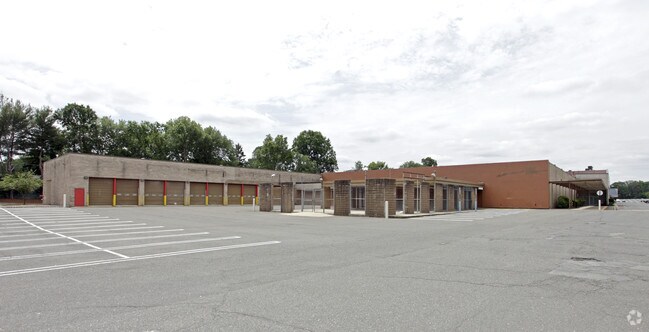


Property Detail
1200 Njsh 22E
Lakewood-New Brunswick, NJ
ADDITIONAL LOTS: F/K/A VORNADO CENTER
14-00203-01-00001-02
SOMERSET
Regionalshoppingcenterormallwithanchorstore
New Jersey
B and X Area of moderate flood hazard, usually the area between the limits of the 100-year and 500-year floods.
1.2
2024
12.06 AC
2025
Route 78 East
052002
Northern New Jersey
NEARBY LISTINGS FOR SALE OR LEASE
-
-
-
-
-
-
-
-
No Photo
-
View all North Plainfield listings for sale on LoopNet.com
DEMOGRAPHICS near 1200 Njsh 22E
1 mile
3 mile
5 mile
2025 Total Population
12,024
121,869
241,994
2030 Population
12,425
126,316
252,403
Pop Growth 2025-2030
+ 3.33%
+ 3.65%
+ 4.30%
Average Age
39
39
40
2025 Total Households
4,071
38,789
80,187
HH Growth 2025-2030
+ 3.49%
+ 3.80%
+ 4.46%
Median Household Inc
$95,951
$95,105
$119,226
Avg Household Size
2.90
3.00
2.90
2025 Avg HH Vehicles
2.00
2.00
2.00
Median Home Value
$415,008
$450,024
$509,415
Median Year Built
1957
1957
1962
Nearby Places
Map Layers
Map Styles
 Street
 Aerial
Layers
 Traffic
 Biking
Places
Listings with unknown addresses are not visible on the map
- Restaurants
- Banks
- Shops
- Fitness
- Groceries
PUBLIC TRANSPORTATION
COMMUTER RAIL
Plainfield (Raritan Valley Line - NJ Transit Commuter Rail (NJ Transit))
Drive
Walk
Distance
Plainfield (Raritan Valley Line - NJ Transit Commuter Rail (NJ Transit))
7 min
2.9 mi
Dunellen (Raritan Valley Line - NJ Transit Commuter Rail (NJ Transit))
Drive
Walk
Distance
Dunellen (Raritan Valley Line - NJ Transit Commuter Rail (NJ Transit))
9 min
3.4 mi
AIRPORT
Newark Liberty International
Drive
Walk
Distance
Newark Liberty International
31 min
22.0 mi
Trenton Mercer
Drive
Walk
Distance
Trenton Mercer
65 min
41.0 mi
Freight Ports
New York Container Terminal
Drive
Walk
Distance
New York Container Terminal
37 min
21.0 mi
Nearby Properties
Address
Land Use
TOTAL SIZE
Lot Size
Zoning
Address
Land Use
TOTAL SIZE
Lot Size
Zoning
17.01 AC
RM
Address
Land Use
TOTAL SIZE
Lot Size
Zoning
20.08 AC
RML1
Address
Land Use
TOTAL SIZE
Lot Size
Zoning
17.64 AC
R10A
Address
Land Use
TOTAL SIZE
Lot Size
Zoning
26.87 AC
H-D
Address
Land Use
TOTAL SIZE
Lot Size
Zoning
10.09 AC
Address
Land Use
TOTAL SIZE
Lot Size
Zoning
27.70 AC
Address
Land Use
TOTAL SIZE
Lot Size
Zoning
34.27 AC
R65
Address
Land Use
TOTAL SIZE
Lot Size
Zoning
16.21 AC
RM
Address
Land Use
TOTAL SIZE
Lot Size
Zoning
67.22 AC
R65
Address
Land Use
TOTAL SIZE
Lot Size
Zoning
233,217 SF
36.91 AC
LI5
Address
Land Use
TOTAL SIZE
Lot Size
Zoning
Address
Land Use
TOTAL SIZE
Lot Size
Zoning
15.79 AC
H-D
Address
Land Use
TOTAL SIZE
Lot Size
Zoning
137,228 SF
15 AC
R75
Address
Land Use
TOTAL SIZE
Lot Size
Zoning
27 AC
MD
Address
Land Use
TOTAL SIZE
Lot Size
Zoning
19.84 AC
Address
Land Use
TOTAL SIZE
Lot Size
Zoning
9.85 AC
10A
Address
Land Use
TOTAL SIZE
Lot Size
Zoning
16.97 AC
Address
Land Use
TOTAL SIZE
Lot Size
Zoning
30.80 AC
R10
Address
Land Use
TOTAL SIZE
Lot Size
Zoning
2,800 SF
16.73 AC
R20V
Address
Land Use
TOTAL SIZE
Lot Size
Zoning
13.83 AC
CB
Address
Land Use
TOTAL SIZE
Lot Size
Zoning
19.84 AC
H-D
Address
Land Use
TOTAL SIZE
Lot Size
Zoning
10.61 AC
IND
Address
Land Use
TOTAL SIZE
Lot Size
Zoning
30.40 AC
PR
Address
Land Use
TOTAL SIZE
Lot Size
Zoning
19.19 AC
R-3
Address
Land Use
TOTAL SIZE
Lot Size
Zoning
10,328 SF
7.53 AC
R4
Address
Land Use
TOTAL SIZE
Lot Size
Zoning
21.53 AC
H-D
Address
Land Use
TOTAL SIZE
Lot Size
Zoning
80,262 SF
11.47 AC
ER
Address
Land Use
TOTAL SIZE
Lot Size
Zoning
122,820 SF
14.65 AC
H-D
Address
Land Use
TOTAL SIZE
Lot Size
Zoning
23.45 AC
RHC
Address
Land Use
TOTAL SIZE
Lot Size
Zoning
11.20 AC
The World's #1 Commercial Real Estate Marketplace
Connect with us
© 2026 CoStar Group
The information above has been obtained from sources believed reliable. While we do not doubt its accuracy we have not verified it and make no guarantee, warranty or representation about it. It is your responsibility to independently confirm its accuracy and completeness. Any projections, opinions, assumptions, or estimates used are for example only and do not represent the current or future performance of the property. The value of this transaction to you depends on tax and other factors which should be evaluated by your tax, financial, and legal advisors. You and your advisors should conduct a careful, independent investigation of the property to determine to your satisfaction the suitability of the property for your needs.