Property Record
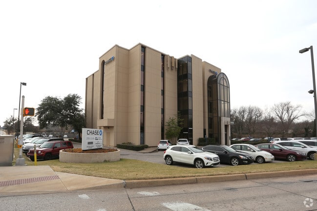
1200 Nw 63Rd St, Oklahoma City, OK 73116


Current Lease Availabilities
NEARBY LISTINGS FOR SALE OR LEASE
Property Detail
1200 Nw 63Rd St
Oklahoma City, OK
Nichols Hills Glenbrook 1 Rplt
085351000
NICHOLS HILLS GLENBROOK 1 RPLT 001 001
Commercialnec
Oklahoma
AE
Oklahoma
40109C0170H
1
2023
2.17 AC
2024
North
106503
Oklahoma City
39,367 SF
DEMOGRAPHICS near 1200 Nw 63Rd St
1 Mile
3 Mile
5 Mile
2024 Total Population
4,165
72,965
190,636
2029 Population
4,265
74,872
196,397
Pop Growth 2024-2029
+ 2.40%
+ 2.61%
+ 3.02%
Average Age
47
39
38
2024 Total Households
1,957
33,953
87,212
HH Growth 2024-2029
+ 2.45%
+ 2.66%
+ 3.15%
Median Household Inc
$103,274
$54,836
$50,266
Avg Household Size
2.10
2.10
2.10
2024 Avg HH Vehicles
2.00
2.00
2.00
Median Home Value
$562,883
$198,540
$174,035
Median Year Built
1964
1959
1963
Nearby Places
Map Layers
Map Styles
 Street
 Aerial
- Restaurants
- Banks
- Shops
- Fitness
- Groceries
PUBLIC TRANSPORTATION
COMMUTER RAIL
DRIVE
WALK
Distance
11 min
5.9 mi
AIRPORT
Will Rogers World
DRIVE
WALK
Distance
Will Rogers World
24 min
13.5 mi
Nearby Properties
Address
Land Use
TOTAL SIZE
Lot Size
Zoning
Address
Land Use
TOTAL SIZE
Lot Size
Zoning
233,053 SF
18.93 AC
O-2
Address
Land Use
TOTAL SIZE
Lot Size
Zoning
819,976 SF
21.87 AC
C-3
Address
Land Use
TOTAL SIZE
Lot Size
Zoning
442,553 SF
58.86 AC
PUD
Address
Land Use
TOTAL SIZE
Lot Size
Zoning
777,727 SF
54.25 AC
I-2
Address
Land Use
TOTAL SIZE
Lot Size
Zoning
467,216 SF
66.90 AC
C-3
Address
Land Use
TOTAL SIZE
Lot Size
Zoning
58,071 SF
4.15 AC
PUD
Address
Land Use
TOTAL SIZE
Lot Size
Zoning
327,248 SF
14.22 AC
R-4
Address
Land Use
TOTAL SIZE
Lot Size
Zoning
312,308 SF
9.76 AC
C-3
Address
Land Use
TOTAL SIZE
Lot Size
Zoning
294,583 SF
20.14 AC
PUD
Address
Land Use
TOTAL SIZE
Lot Size
Zoning
93,244 SF
7.54 AC
PUD
Address
Land Use
TOTAL SIZE
Lot Size
Zoning
430,092 SF
17.35 AC
R-4
Address
Land Use
TOTAL SIZE
Lot Size
Zoning
202,147 SF
44.36 AC
PUD
Address
Land Use
TOTAL SIZE
Lot Size
Zoning
485,764 SF
6.05 AC
C-3
Address
Land Use
TOTAL SIZE
Lot Size
Zoning
452,123 SF
5.64 AC
O-2
Address
Land Use
TOTAL SIZE
Lot Size
Zoning
10,922 SF
1.04 AC
SPUD
Address
Land Use
TOTAL SIZE
Lot Size
Zoning
377,880 SF
24.34 AC
PUD
Address
Land Use
TOTAL SIZE
Lot Size
Zoning
258,381 SF
2.54 AC
PUD
Address
Land Use
TOTAL SIZE
Lot Size
Zoning
28,099 SF
1.21 AC
O-2
Address
Land Use
TOTAL SIZE
Lot Size
Zoning
254,126 SF
2.11 AC
SPUD
Address
Land Use
TOTAL SIZE
Lot Size
Zoning
105,426 SF
15.58 AC
O-2
Address
Land Use
TOTAL SIZE
Lot Size
Zoning
26,340 SF
2.38 AC
NC
Address
Land Use
TOTAL SIZE
Lot Size
Zoning
21,000 SF
2.64 AC
I-1
Address
Land Use
TOTAL SIZE
Lot Size
Zoning
244,699 SF
11.83 AC
C-3
Address
Land Use
TOTAL SIZE
Lot Size
Zoning
681,708 SF
20.54 AC
C-3
Address
Land Use
TOTAL SIZE
Lot Size
Zoning
160,389 SF
16.48 AC
PUD
Address
Land Use
TOTAL SIZE
Lot Size
Zoning
436,316 SF
5.23 AC
I-1
Address
Land Use
TOTAL SIZE
Lot Size
Zoning
164,880 SF
8.95 AC
O-2
Address
Land Use
TOTAL SIZE
Lot Size
Zoning
285,771 SF
8.64 AC
PUD
Address
Land Use
TOTAL SIZE
Lot Size
Zoning
1 SF
3.72 AC
C-3
The World's #1 Commercial Real Estate Marketplace
Connect with us
© 2026 CoStar Group
The information above has been obtained from sources believed reliable. While we do not doubt its accuracy we have not verified it and make no guarantee, warranty or representation about it. It is your responsibility to independently confirm its accuracy and completeness. Any projections, opinions, assumptions, or estimates used are for example only and do not represent the current or future performance of the property. The value of this transaction to you depends on tax and other factors which should be evaluated by your tax, financial, and legal advisors. You and your advisors should conduct a careful, independent investigation of the property to determine to your satisfaction the suitability of the property for your needs.