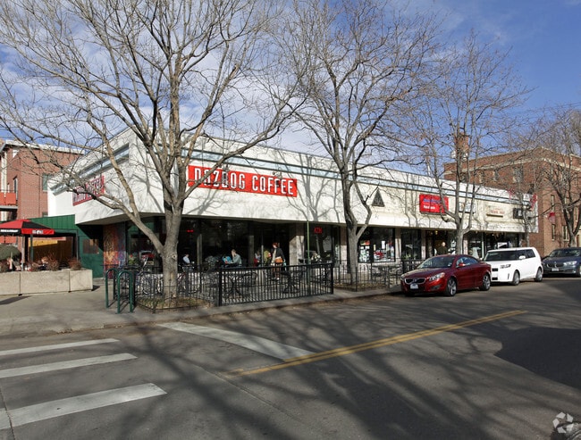
Property Record
1201 E 9Th Ave, Denver, CO 80218

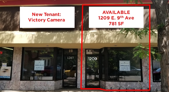
Current Lease Availabilities
Property Detail
1201 E 9Th Ave
5023-04-011
L 19 & 20 BLK 19 INSLEES ADD AMD MAP
Storebuilding
DENVER
G-MX-3
Colorado
B and X Area of moderate flood hazard, usually the area between the limits of the 100-year and 500-year floods.
19,20
2024
0.14 AC
2025
Central
003205
Denver
10,914 SF
Denver-Aurora-Centennial, CO
NEARBY LISTINGS FOR SALE OR LEASE
DEMOGRAPHICS near 1201 E 9Th Ave
1 mile
3 mile
5 mile
2025 Total Population
48,783
242,114
539,167
2030 Population
50,191
249,165
552,651
Pop Growth 2025-2030
+ 2.89%
+ 2.91%
+ 2.50%
Average Age
39
38
38
2025 Total Households
30,748
130,057
253,197
HH Growth 2025-2030
+ 2.93%
+ 3.13%
+ 2.72%
Median Household Inc
$85,826
$107,148
$98,490
Avg Household Size
1.50
1.80
2.00
2025 Avg HH Vehicles
1.00
1.00
1.00
Median Home Value
$735,898
$828,794
$735,264
Median Year Built
1963
1974
1969
Nearby Places
Map Layers
Map Styles
 Street
 Aerial
Layers
 Traffic
 Biking
Places
Listings with unknown addresses are not visible on the map
- Restaurants
- Banks
- Shops
- Fitness
- Groceries
PUBLIC TRANSPORTATION
AIRPORT
Denver International
Drive
Walk
Distance
Denver International
41 min
25.2 mi
Freight Ports
Port of Shreveport
Drive
Walk
Distance
Port of Shreveport
1 min
812.3 mi
Nearby Properties
Address
Land Use
TOTAL SIZE
Lot Size
Zoning
Address
Land Use
TOTAL SIZE
Lot Size
Zoning
921,863 SF
2.01 AC
C-MX
Address
Land Use
TOTAL SIZE
Lot Size
Zoning
1,882,179 SF
21.15 AC
D-TD
Address
Land Use
TOTAL SIZE
Lot Size
Zoning
1,721,086 SF
21.34 AC
C-MU-30
Address
Land Use
TOTAL SIZE
Lot Size
Zoning
798,837 SF
1.67 AC
C-MX
Address
Land Use
TOTAL SIZE
Lot Size
Zoning
598,652 SF
1.38 AC
G-TR
Address
Land Use
TOTAL SIZE
Lot Size
Zoning
565,418 SF
4.07 AC
C-RX
Address
Land Use
TOTAL SIZE
Lot Size
Zoning
657,947 SF
5.02 AC
C-RX
Address
Land Use
TOTAL SIZE
Lot Size
Zoning
729,679 SF
C-MX
Address
Land Use
TOTAL SIZE
Lot Size
Zoning
857,233 SF
10.26 AC
CMP-H
Address
Land Use
TOTAL SIZE
Lot Size
Zoning
856,519 SF
10.04 AC
B-3
Address
Land Use
TOTAL SIZE
Lot Size
Zoning
6,252 SF
1.05 AC
C-MX
Address
Land Use
TOTAL SIZE
Lot Size
Zoning
472,235 SF
1.98 AC
C-RX
Address
Land Use
TOTAL SIZE
Lot Size
Zoning
1,096,923 SF
16.14 AC
CMP-H
Address
Land Use
TOTAL SIZE
Lot Size
Zoning
624,481 SF
1.87 AC
C-MX
Address
Land Use
TOTAL SIZE
Lot Size
Zoning
451,860 SF
1 AC
C-MX
Address
Land Use
TOTAL SIZE
Lot Size
Zoning
794,383 SF
0.90 AC
D-TD
Address
Land Use
TOTAL SIZE
Lot Size
Zoning
694,425 SF
1.92 AC
C-MX
Address
Land Use
TOTAL SIZE
Lot Size
Zoning
411,402 SF
6.34 AC
C-RX
Address
Land Use
TOTAL SIZE
Lot Size
Zoning
405,436 SF
2.45 AC
C-MX
Address
Land Use
TOTAL SIZE
Lot Size
Zoning
299,368 SF
0.71 AC
C-MX
Address
Land Use
TOTAL SIZE
Lot Size
Zoning
297,776 SF
2.88 AC
C-MX
Address
Land Use
TOTAL SIZE
Lot Size
Zoning
311,406 SF
1.74 AC
C-MX
Address
Land Use
TOTAL SIZE
Lot Size
Zoning
402,700 SF
1.15 AC
C-RX
Address
Land Use
TOTAL SIZE
Lot Size
Zoning
411,031 SF
1.66 AC
I-MX
Address
Land Use
TOTAL SIZE
Lot Size
Zoning
352,226 SF
1.01 AC
ASQ
Address
Land Use
TOTAL SIZE
Lot Size
Zoning
296,778 SF
2.28 AC
U-MS
Address
Land Use
TOTAL SIZE
Lot Size
Zoning
341,972 SF
1.21 AC
G-TR
Address
Land Use
TOTAL SIZE
Lot Size
Zoning
1,048,471 SF
2.44 AC
PUD
Address
Land Use
TOTAL SIZE
Lot Size
Zoning
412,345 SF
0.82 AC
C-MX
Address
Land Use
TOTAL SIZE
Lot Size
Zoning
365,674 SF
2.60 AC
G-MU
The World's #1 Commercial Real Estate Marketplace
Connect with us
© 2026 CoStar Group
The information above has been obtained from sources believed reliable. While we do not doubt its accuracy we have not verified it and make no guarantee, warranty or representation about it. It is your responsibility to independently confirm its accuracy and completeness. Any projections, opinions, assumptions, or estimates used are for example only and do not represent the current or future performance of the property. The value of this transaction to you depends on tax and other factors which should be evaluated by your tax, financial, and legal advisors. You and your advisors should conduct a careful, independent investigation of the property to determine to your satisfaction the suitability of the property for your needs.