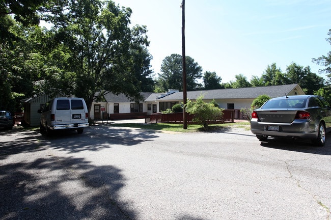
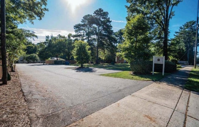
Property Record
1201 Kent Rd, Raleigh, NC 27606

Save to a Folder
{{folder.Name}}
{{folder.ListingIds.length}} Properties
{{folder.ListingIds.length}} Property
Create a New Folder
Property Detail
1201 Kent Rd
0793.05-19-0817-000
PT LT 4 HINTON PROP
Daycare
Wake
R-10
North Carolina
B and X Area of moderate flood hazard, usually the area between the limits of the 100-year and 500-year floods.
4
2025
0.81 AC
2025
West Raleigh
052408
Raleigh/Durham
4,071 SF
Raleigh-Cary, NC
NEARBY LISTINGS FOR SALE OR LEASE
DEMOGRAPHICS near 1201 Kent Rd
1 mile
3 mile
5 mile
2025 Total Population
19,756
105,517
232,259
2030 Population
21,364
114,155
251,148
Pop Growth 2025-2030
+ 8.14%
+ 8.19%
+ 8.13%
Average Age
30
34
37
2025 Total Households
7,315
45,938
100,969
HH Growth 2025-2030
+ 9.24%
+ 9.23%
+ 8.92%
Median Household Inc
$39,626
$77,015
$85,699
Avg Household Size
2.20
2.00
2.10
2025 Avg HH Vehicles
2.00
2.00
2.00
Median Home Value
$438,889
$604,131
$603,317
Median Year Built
1985
1993
1992
Nearby Places
Map Layers
Map Styles
 Street
 Aerial
Layers
 Traffic
 Biking
Places
Listings with unknown addresses are not visible on the map
- Restaurants
- Banks
- Shops
- Fitness
- Groceries
PUBLIC TRANSPORTATION
COMMUTER RAIL
Raleigh Union Station (Piedmont - North Carolina by Train (NC Train))
Drive
Walk
Distance
Raleigh Union Station (Piedmont - North Carolina by Train (NC Train))
8 min
3.7 mi
Cary Station (Piedmont - North Carolina by Train (NC Train))
Drive
Walk
Distance
Cary Station (Piedmont - North Carolina by Train (NC Train))
11 min
5.3 mi
AIRPORT
Raleigh-Durham International
Drive
Walk
Distance
Raleigh-Durham International
19 min
11.2 mi
SALE & LEASE HISTORY
LISTING DATE
SALE/LEASE

Sep 18, 2024
For Sale
Aug 14, 2025
For Sale
Nearby Properties
Address
Land Use
TOTAL SIZE
Lot Size
Zoning
Address
Land Use
TOTAL SIZE
Lot Size
Zoning
5,616,802 SF
507.97 AC
OX-12
Address
Land Use
TOTAL SIZE
Lot Size
Zoning
972,279 SF
4.05 AC
DX-20
Address
Land Use
TOTAL SIZE
Lot Size
Zoning
1,109,877 SF
746.53 AC
CMP
Address
Land Use
TOTAL SIZE
Lot Size
Zoning
1,801,169 SF
59.60 AC
OX-12
Address
Land Use
TOTAL SIZE
Lot Size
Zoning
770,311 SF
80.70 AC
PD
Address
Land Use
TOTAL SIZE
Lot Size
Zoning
854,180 SF
210.81 AC
OX-4
Address
Land Use
TOTAL SIZE
Lot Size
Zoning
458,830 SF
3.98 AC
DX-20
Address
Land Use
TOTAL SIZE
Lot Size
Zoning
294,812 SF
999.47 AC
AP
Address
Land Use
TOTAL SIZE
Lot Size
Zoning
613,087 SF
266.85 AC
PD
Address
Land Use
TOTAL SIZE
Lot Size
Zoning
1,810,132 SF
OX-12
Address
Land Use
TOTAL SIZE
Lot Size
Zoning
706,810 SF
40.78 AC
IH
Address
Land Use
TOTAL SIZE
Lot Size
Zoning
12,850 SF
96.80 AC
OX-12
Address
Land Use
TOTAL SIZE
Lot Size
Zoning
675,817 SF
3.56 AC
DX-12
Address
Land Use
TOTAL SIZE
Lot Size
Zoning
372,222 SF
9.64 AC
DX-12
Address
Land Use
TOTAL SIZE
Lot Size
Zoning
403,230 SF
197.34 AC
IX-3
Address
Land Use
TOTAL SIZE
Lot Size
Zoning
250,448 SF
25.28 AC
OX-3
Address
Land Use
TOTAL SIZE
Lot Size
Zoning
982,323 SF
154.02 AC
OX-7
Address
Land Use
TOTAL SIZE
Lot Size
Zoning
1,039,527 SF
22.85 AC
OX-7
Address
Land Use
TOTAL SIZE
Lot Size
Zoning
179,565 SF
1.10 AC
DX-7
Address
Land Use
TOTAL SIZE
Lot Size
Zoning
524,391 SF
4.13 AC
NX-5
Address
Land Use
TOTAL SIZE
Lot Size
Zoning
654,148 SF
1.21 AC
DX-40
Address
Land Use
TOTAL SIZE
Lot Size
Zoning
462,217 SF
1.01 AC
DX-20
Address
Land Use
TOTAL SIZE
Lot Size
Zoning
834,950 SF
3.91 AC
OX-12
Address
Land Use
TOTAL SIZE
Lot Size
Zoning
561,966 SF
3.81 AC
IX-7
Address
Land Use
TOTAL SIZE
Lot Size
Zoning
426,539 SF
2.90 AC
NX-5
Address
Land Use
TOTAL SIZE
Lot Size
Zoning
613,248 SF
2.20 AC
IND-2
Address
Land Use
TOTAL SIZE
Lot Size
Zoning
580,268 SF
9.02 AC
PD
Address
Land Use
TOTAL SIZE
Lot Size
Zoning
931,884 SF
10.21 AC
CMP
Address
Land Use
TOTAL SIZE
Lot Size
Zoning
378,159 SF
22.40 AC
OX-7
Address
Land Use
TOTAL SIZE
Lot Size
Zoning
201,558 SF
4.05 AC
DX-12
The World's #1 Commercial Real Estate Marketplace
Connect with us
© 2026 CoStar Group
The information above has been obtained from sources believed reliable. While we do not doubt its accuracy we have not verified it and make no guarantee, warranty or representation about it. It is your responsibility to independently confirm its accuracy and completeness. Any projections, opinions, assumptions, or estimates used are for example only and do not represent the current or future performance of the property. The value of this transaction to you depends on tax and other factors which should be evaluated by your tax, financial, and legal advisors. You and your advisors should conduct a careful, independent investigation of the property to determine to your satisfaction the suitability of the property for your needs.