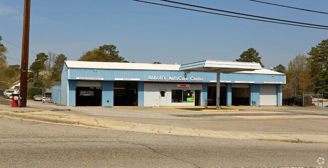
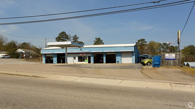
Property Record
1201 Percival Rd, Columbia, SC 29223

NEARBY LISTINGS FOR SALE OR LEASE
Property Detail
1201 Percival Rd
Columbia, SC
Forest Acres
16815-04-13
PARCEL 3 150X196.3X149.7X192.2 #SU WOODFIELD #PR RB2362-250 X-64/65 S-8/9
Commercialnec
Richland
X
South Carolina
45079C0266L
4
2025
0.67 AC
2024
Northeast Columbia
011305
Columbia
5,700 SF
DEMOGRAPHICS near 1201 Percival Rd
1 Mile
3 Mile
5 Mile
2024 Total Population
6,213
50,650
116,802
2029 Population
6,222
51,532
118,644
Pop Growth 2024-2029
+ 0.14%
+ 1.74%
+ 1.58%
Average Age
39
36
38
2024 Total Households
2,536
18,083
47,076
HH Growth 2024-2029
+ 0.12%
+ 1.86%
+ 1.67%
Median Household Inc
$51,414
$51,734
$51,869
Avg Household Size
2.40
2.30
2.20
2024 Avg HH Vehicles
2.00
2.00
2.00
Median Home Value
$156,069
$201,039
$201,909
Median Year Built
1967
1976
1975
Nearby Places
Map Layers
Map Styles
 Street
 Aerial
- Restaurants
- Banks
- Shops
- Fitness
- Groceries
PUBLIC TRANSPORTATION
COMMUTER RAIL
DRIVE
WALK
Distance
18 min
8.2 mi
AIRPORT
Columbia Metro
DRIVE
WALK
Distance
Columbia Metro
33 min
20.5 mi
SALE & LEASE HISTORY
LISTING DATE
SALE/LEASE

May 06, 2019
For Sale
May 06, 2019
For Sale
Nearby Properties
Address
Land Use
TOTAL SIZE
Lot Size
Zoning
Address
Land Use
TOTAL SIZE
Lot Size
Zoning
1,704.85 AC
RU
Address
Land Use
TOTAL SIZE
Lot Size
Zoning
354,813 SF
20.66 AC
RM-HD
Address
Land Use
TOTAL SIZE
Lot Size
Zoning
338,744 SF
21.28 AC
RM-HD
Address
Land Use
TOTAL SIZE
Lot Size
Zoning
172,390 SF
19.87 AC
GC
Address
Land Use
TOTAL SIZE
Lot Size
Zoning
333,825 SF
17.75 AC
GC
Address
Land Use
TOTAL SIZE
Lot Size
Zoning
313,244 SF
12.75 AC
RM-HD
Address
Land Use
TOTAL SIZE
Lot Size
Zoning
260,572 SF
15 AC
GC
Address
Land Use
TOTAL SIZE
Lot Size
Zoning
288,000 SF
17.34 AC
OI
Address
Land Use
TOTAL SIZE
Lot Size
Zoning
231,426 SF
10 AC
C-3
Address
Land Use
TOTAL SIZE
Lot Size
Zoning
155,314 SF
26.04 AC
OI
Address
Land Use
TOTAL SIZE
Lot Size
Zoning
299,909 SF
14.49 AC
RM-HD
Address
Land Use
TOTAL SIZE
Lot Size
Zoning
169,291 SF
18.97 AC
C-3
Address
Land Use
TOTAL SIZE
Lot Size
Zoning
200,609 SF
17.97 AC
GC
Address
Land Use
TOTAL SIZE
Lot Size
Zoning
179,652 SF
14.98 AC
RM-HD
Address
Land Use
TOTAL SIZE
Lot Size
Zoning
341,550 SF
20.66 AC
RM-HD
Address
Land Use
TOTAL SIZE
Lot Size
Zoning
129,721 SF
3.72 AC
C-3
Address
Land Use
TOTAL SIZE
Lot Size
Zoning
183,237 SF
13.65 AC
GC
Address
Land Use
TOTAL SIZE
Lot Size
Zoning
147,062 SF
13.20 AC
GC
Address
Land Use
TOTAL SIZE
Lot Size
Zoning
259,948 SF
14.40 AC
RM-HD
Address
Land Use
TOTAL SIZE
Lot Size
Zoning
202,048 SF
20.98 AC
C-3
Address
Land Use
TOTAL SIZE
Lot Size
Zoning
414,262 SF
34.45 AC
RM-HD
Address
Land Use
TOTAL SIZE
Lot Size
Zoning
23,379 SF
3.76 AC
M-1
Address
Land Use
TOTAL SIZE
Lot Size
Zoning
113,510 SF
11.60 AC
GC
Address
Land Use
TOTAL SIZE
Lot Size
Zoning
223,692 SF
12 AC
GC
Address
Land Use
TOTAL SIZE
Lot Size
Zoning
20 AC
C-3
Address
Land Use
TOTAL SIZE
Lot Size
Zoning
156,185 SF
12.68 AC
GC
Address
Land Use
TOTAL SIZE
Lot Size
Zoning
51,353 SF
7.01 AC
GC
Address
Land Use
TOTAL SIZE
Lot Size
Zoning
132,097 SF
10.63 AC
GC
Address
Land Use
TOTAL SIZE
Lot Size
Zoning
145,081 SF
22.36 AC
C-3
Address
Land Use
TOTAL SIZE
Lot Size
Zoning
97,683 SF
11.60 AC
C-3
The World's #1 Commercial Real Estate Marketplace
Connect with us
© 2025 CoStar Group
The information above has been obtained from sources believed reliable. While we do not doubt its accuracy we have not verified it and make no guarantee, warranty or representation about it. It is your responsibility to independently confirm its accuracy and completeness. Any projections, opinions, assumptions, or estimates used are for example only and do not represent the current or future performance of the property. The value of this transaction to you depends on tax and other factors which should be evaluated by your tax, financial, and legal advisors. You and your advisors should conduct a careful, independent investigation of the property to determine to your satisfaction the suitability of the property for your needs.