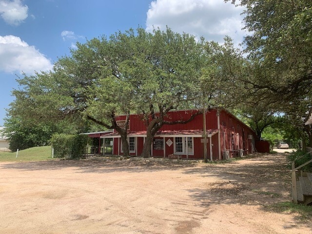
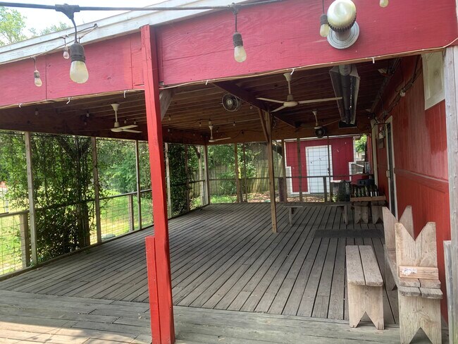
Property Record
12015 W Us Highway 290, Austin, TX 78737

Property Detail
12015 W Us Highway 290
R15489
ABS 245 8-2377-01-14 WILLIAM S HOLTON SURVEY 3.50 AC GEO#90400775
Commercialnec
HAYS
B and X Area of moderate flood hazard, usually the area between the limits of the 100-year and 500-year floods.
Texas
2024
3.50 AC
2025
Hays County
010815
Austin
8,684 SF
Austin-Round Rock-San Marcos, TX
NEARBY LISTINGS FOR SALE OR LEASE
DEMOGRAPHICS near 12015 W Us Highway 290
1 mile
3 mile
5 mile
2024 Total Population
4,058
16,313
50,582
2029 Population
4,690
18,628
55,836
Pop Growth 2024-2029
+ 15.57%
+ 14.19%
+ 10.39%
Average Age
41
40
40
2024 Total Households
1,460
5,732
17,466
HH Growth 2024-2029
+ 16.64%
+ 15.20%
+ 11.36%
Median Household Inc
$138,834
$164,318
$182,137
Avg Household Size
2.80
2.80
2.90
2024 Avg HH Vehicles
2.00
2.00
2.00
Median Home Value
$796,238
$778,133
$785,260
Median Year Built
2006
2007
2007
Nearby Places
Map Layers
Map Styles
 Street
 Aerial
Transit
 Traffic
 Biking
Places
Listings with unknown addresses are not visible on the map
- Restaurants
- Banks
- Shops
- Fitness
- Groceries
PUBLIC TRANSPORTATION
AIRPORT
Austin-Bergstrom International
Drive
Walk
Distance
Austin-Bergstrom International
36 min
22.0 mi
Freight Ports
Calhoun Port
Drive
Walk
Distance
Calhoun Port
202 min
165.5 mi
SALE & LEASE HISTORY
LISTING DATE
SALE/LEASE

Sep 09, 2020
For Sale
Jul 16, 2020
For Lease
Apr 14, 2021
For Lease
Nearby Properties
Address
Land Use
TOTAL SIZE
Lot Size
Zoning
Address
Land Use
TOTAL SIZE
Lot Size
Zoning
399,662 SF
16.72 AC
Address
Land Use
TOTAL SIZE
Lot Size
Zoning
324,987 SF
8.29 AC
Address
Land Use
TOTAL SIZE
Lot Size
Zoning
191,928 SF
4.79 AC
Address
Land Use
TOTAL SIZE
Lot Size
Zoning
219,299 SF
4.89 AC
Address
Land Use
TOTAL SIZE
Lot Size
Zoning
275,753 SF
15.68 AC
Address
Land Use
TOTAL SIZE
Lot Size
Zoning
64,670 SF
13.53 AC
Address
Land Use
TOTAL SIZE
Lot Size
Zoning
231,472 SF
9.53 AC
Address
Land Use
TOTAL SIZE
Lot Size
Zoning
103,045 SF
59.39 AC
Address
Land Use
TOTAL SIZE
Lot Size
Zoning
77,801 SF
14.49 AC
Address
Land Use
TOTAL SIZE
Lot Size
Zoning
121,400 SF
28.99 AC
Address
Land Use
TOTAL SIZE
Lot Size
Zoning
59,133 SF
13.33 AC
Address
Land Use
TOTAL SIZE
Lot Size
Zoning
37,380 SF
4.35 AC
Address
Land Use
TOTAL SIZE
Lot Size
Zoning
84,970 SF
7.19 AC
Address
Land Use
TOTAL SIZE
Lot Size
Zoning
110,760 SF
11.75 AC
Address
Land Use
TOTAL SIZE
Lot Size
Zoning
101,453 SF
14.29 AC
Address
Land Use
TOTAL SIZE
Lot Size
Zoning
47,530 SF
16.08 AC
Address
Land Use
TOTAL SIZE
Lot Size
Zoning
33,145 SF
2.70 AC
Address
Land Use
TOTAL SIZE
Lot Size
Zoning
70,194 SF
2.71 AC
Address
Land Use
TOTAL SIZE
Lot Size
Zoning
18.29 AC
Address
Land Use
TOTAL SIZE
Lot Size
Zoning
3 SF
14.51 AC
Address
Land Use
TOTAL SIZE
Lot Size
Zoning
14,090 SF
3.08 AC
Address
Land Use
TOTAL SIZE
Lot Size
Zoning
43,215 SF
3.85 AC
Address
Land Use
TOTAL SIZE
Lot Size
Zoning
15,750 SF
1.94 AC
Address
Land Use
TOTAL SIZE
Lot Size
Zoning
54,606 SF
12.27 AC
Address
Land Use
TOTAL SIZE
Lot Size
Zoning
17,987 SF
12.07 AC
Address
Land Use
TOTAL SIZE
Lot Size
Zoning
15,000 SF
8.73 AC
Address
Land Use
TOTAL SIZE
Lot Size
Zoning
39,650 SF
9.17 AC
Address
Land Use
TOTAL SIZE
Lot Size
Zoning
15,639 SF
2.10 AC
Address
Land Use
TOTAL SIZE
Lot Size
Zoning
4,852 SF
20.76 AC
Address
Land Use
TOTAL SIZE
Lot Size
Zoning
14,880 SF
1.96 AC
The World's #1 Commercial Real Estate Marketplace
Connect with us
© 2026 CoStar Group
The information above has been obtained from sources believed reliable. While we do not doubt its accuracy we have not verified it and make no guarantee, warranty or representation about it. It is your responsibility to independently confirm its accuracy and completeness. Any projections, opinions, assumptions, or estimates used are for example only and do not represent the current or future performance of the property. The value of this transaction to you depends on tax and other factors which should be evaluated by your tax, financial, and legal advisors. You and your advisors should conduct a careful, independent investigation of the property to determine to your satisfaction the suitability of the property for your needs.