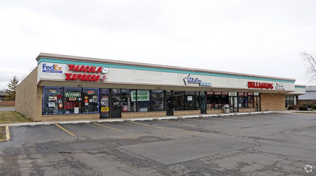
Property Record
12023 S Pulaski Rd, Alsip, IL 60803
NEARBY LISTINGS FOR SALE OR LEASE
Property Detail
12023 S Pulaski Rd
Chicago-Naperville-Elgin, IL-IN-WI
Crawford Plaza Resub Of Lt3 In Burkes
24-26-100-024-0000
(CRAWFORD) PLAZA RESUB OF LT3 IN BURKES RESUB OF LT14 EX W50 IN BRAYTON FARMS UNIT2 SUB OF WH NW SEC 26-37-13
Regionalshoppingcenterormallwithanchorstore
Cook
X
Illinois
17031C0637J
3,14
2023
2.21 AC
2024
Near South Cook
823304
Chicago
25,800 SF
DEMOGRAPHICS near 12023 S Pulaski Rd
1 Mile
3 Mile
5 Mile
2024 Total Population
15,664
133,912
371,002
2029 Population
15,212
131,200
361,894
Pop Growth 2024-2029
(2.89%)
(2.03%)
(2.45%)
Average Age
40
41
41
2024 Total Households
6,453
51,910
138,627
HH Growth 2024-2029
(3.24%)
(2.26%)
(2.74%)
Median Household Inc
$58,717
$69,853
$66,652
Avg Household Size
2.40
2.50
2.60
2024 Avg HH Vehicles
2.00
2.00
2.00
Median Home Value
$188,608
$230,616
$213,494
Median Year Built
1971
1964
1960
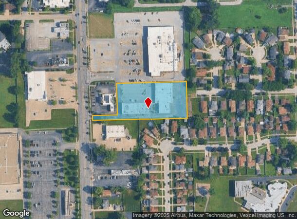
Nearby Places
Map Layers
Map Styles
 Street
 Aerial
- Restaurants
- Banks
- Shops
- Fitness
- Groceries
PUBLIC TRANSPORTATION
COMMUTER RAIL
123Rd Street Station (Rock Island District Line - Northeast Illinois Regional Commuter Railroad (Metra))
DRIVE
WALK
Distance
123Rd Street Station (Rock Island District Line - Northeast Illinois Regional Commuter Railroad (Metra))
7 min
2.7 mi
Prairie Street Station (Rock Island District Line - Northeast Illinois Regional Commuter Railroad (Metra))
DRIVE
WALK
Distance
Prairie Street Station (Rock Island District Line - Northeast Illinois Regional Commuter Railroad (Metra))
6 min
3.1 mi
AIRPORT
Chicago Midway International
DRIVE
WALK
Distance
Chicago Midway International
18 min
10.0 mi
Chicago O'Hare International
DRIVE
WALK
Distance
Chicago O'Hare International
46 min
32.9 mi
Freight Ports
Port Milwaukee
DRIVE
WALK
Distance
Port Milwaukee
127 min
104.7 mi
SALE & LEASE HISTORY
LISTING DATE
SALE/LEASE

Sep 25, 2016
For Lease
Oct 10, 2023
For Sale
Oct 05, 2017
For Sale
Nov 03, 2018
For Lease
May 03, 2017
For Sale
Jul 22, 2019
For Sale
Aug 18, 2022
For Lease
Aug 07, 2017
For Lease
Apr 07, 2017
For Lease
Nearby Properties
Address
Land Use
TOTAL SIZE
Lot Size
Zoning
Address
Land Use
TOTAL SIZE
Lot Size
Zoning
13.59 AC
MU
Address
Land Use
TOTAL SIZE
Lot Size
Zoning
23.81 AC
Address
Land Use
TOTAL SIZE
Lot Size
Zoning
307,335 SF
24.17 AC
PD 770
Address
Land Use
TOTAL SIZE
Lot Size
Zoning
48,792 SF
8.71 AC
RT-4
Address
Land Use
TOTAL SIZE
Lot Size
Zoning
63,930 SF
3.49 AC
PD 181
Address
Land Use
TOTAL SIZE
Lot Size
Zoning
495,815 SF
20.78 AC
Address
Land Use
TOTAL SIZE
Lot Size
Zoning
101,169 SF
13.07 AC
Address
Land Use
TOTAL SIZE
Lot Size
Zoning
Address
Land Use
TOTAL SIZE
Lot Size
Zoning
401,021 SF
27.42 AC
Address
Land Use
TOTAL SIZE
Lot Size
Zoning
380,924 SF
19.13 AC
Address
Land Use
TOTAL SIZE
Lot Size
Zoning
421,052 SF
26.15 AC
Address
Land Use
TOTAL SIZE
Lot Size
Zoning
510,332 SF
23.97 AC
Address
Land Use
TOTAL SIZE
Lot Size
Zoning
5.66 AC
Address
Land Use
TOTAL SIZE
Lot Size
Zoning
152,306 SF
13.40 AC
Address
Land Use
TOTAL SIZE
Lot Size
Zoning
129,837 SF
10.44 AC
PD 770
Address
Land Use
TOTAL SIZE
Lot Size
Zoning
185,748 SF
15.30 AC
Address
Land Use
TOTAL SIZE
Lot Size
Zoning
405,045 SF
14.49 AC
Address
Land Use
TOTAL SIZE
Lot Size
Zoning
113,963 SF
10.55 AC
Address
Land Use
TOTAL SIZE
Lot Size
Zoning
Address
Land Use
TOTAL SIZE
Lot Size
Zoning
869,275 SF
24.34 AC
Address
Land Use
TOTAL SIZE
Lot Size
Zoning
283,947 SF
13.27 AC
Address
Land Use
TOTAL SIZE
Lot Size
Zoning
320,038 SF
13.04 AC
Address
Land Use
TOTAL SIZE
Lot Size
Zoning
98,506 SF
7.66 AC
Address
Land Use
TOTAL SIZE
Lot Size
Zoning
100,496 SF
9.96 AC
Address
Land Use
TOTAL SIZE
Lot Size
Zoning
105,150 SF
4 AC
Address
Land Use
TOTAL SIZE
Lot Size
Zoning
67,488 SF
10 AC
Address
Land Use
TOTAL SIZE
Lot Size
Zoning
261,520 SF
13.59 AC
Address
Land Use
TOTAL SIZE
Lot Size
Zoning
567,900 SF
15.07 AC
Address
Land Use
TOTAL SIZE
Lot Size
Zoning
73,696 SF
6.43 AC
Address
Land Use
TOTAL SIZE
Lot Size
Zoning
162,379 SF
10.59 AC
The World's #1 Commercial Real Estate Marketplace
Connect with us
© 2025 CoStar Group
The information above has been obtained from sources believed reliable. While we do not doubt its accuracy we have not verified it and make no guarantee, warranty or representation about it. It is your responsibility to independently confirm its accuracy and completeness. Any projections, opinions, assumptions, or estimates used are for example only and do not represent the current or future performance of the property. The value of this transaction to you depends on tax and other factors which should be evaluated by your tax, financial, and legal advisors. You and your advisors should conduct a careful, independent investigation of the property to determine to your satisfaction the suitability of the property for your needs.