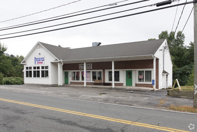
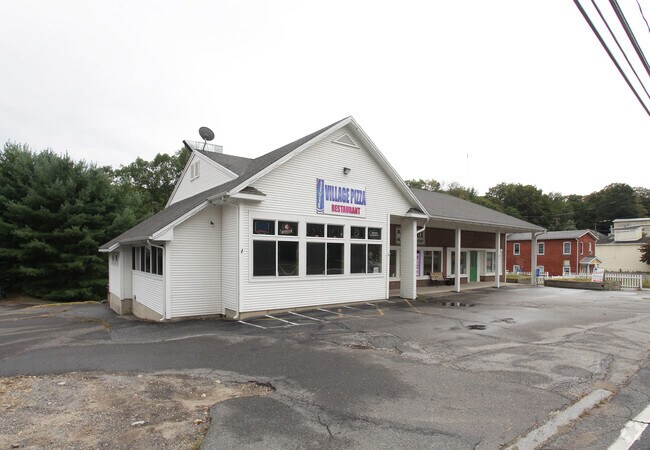
Property Record
1203 Main St, Coventry, CT 06238

Save to a Folder
{{folder.Name}}
{{folder.ListingIds.length}} Properties
{{folder.ListingIds.length}} Property
Create a New Folder
Property Detail
1203 Main St
COVE-000000-L000062-A000000-000002
Capitol
Commercialbuilding
Connecticut
VC
103
2025
0.96 AC
2025
Tolland County
850200
Hartford
3,380 SF
Hartford-West Hartford-East Hartford, CT
NEARBY LISTINGS FOR SALE OR LEASE
DEMOGRAPHICS near 1203 Main St
1 mile
3 mile
5 mile
2025 Total Population
2,173
10,475
41,253
2030 Population
2,234
10,800
42,196
Pop Growth 2025-2030
+ 2.81%
+ 3.10%
+ 2.29%
Average Age
44
41
36
2025 Total Households
956
4,065
12,218
HH Growth 2025-2030
+ 2.82%
+ 3.22%
+ 2.84%
Median Household Inc
$106,224
$102,537
$89,377
Avg Household Size
2.20
2.40
2.40
2025 Avg HH Vehicles
2.00
2.00
2.00
Median Home Value
$305,628
$326,775
$341,811
Median Year Built
1956
1963
1974
Nearby Places
Map Layers
Map Styles
 Street
 Aerial
Layers
 Traffic
 Biking
Places
Listings with unknown addresses are not visible on the map
- Restaurants
- Banks
- Shops
- Fitness
- Groceries
PUBLIC TRANSPORTATION
AIRPORT
Bradley International
Drive
Walk
Distance
Bradley International
59 min
36.3 mi
SALE & LEASE HISTORY
LISTING DATE
SALE/LEASE

Oct 15, 2019
For Lease
Nov 05, 2020
For Lease
Mar 02, 2018
For Lease
Nearby Properties
Address
Land Use
TOTAL SIZE
Lot Size
Zoning
Address
Land Use
TOTAL SIZE
Lot Size
Zoning
98 AC
GR40
Address
Land Use
TOTAL SIZE
Lot Size
Zoning
22.70 AC
RAR90
Address
Land Use
TOTAL SIZE
Lot Size
Zoning
62,452 SF
20 AC
GR80
Address
Land Use
TOTAL SIZE
Lot Size
Zoning
50,098 SF
16.96 AC
RAR90
Address
Land Use
TOTAL SIZE
Lot Size
Zoning
1,296 SF
9.29 AC
GR40
Address
Land Use
TOTAL SIZE
Lot Size
Zoning
14.09 AC
GR40
Address
Land Use
TOTAL SIZE
Lot Size
Zoning
6.20 AC
VR
Address
Land Use
TOTAL SIZE
Lot Size
Zoning
12,277 SF
15.64 AC
RAR90
Address
Land Use
TOTAL SIZE
Lot Size
Zoning
3,210 SF
1 AC
RAR90
Address
Land Use
TOTAL SIZE
Lot Size
Zoning
22.05 AC
RAR90
Address
Land Use
TOTAL SIZE
Lot Size
Zoning
44.90 AC
GR80
Address
Land Use
TOTAL SIZE
Lot Size
Zoning
10,984 SF
8.88 AC
GR80
Address
Land Use
TOTAL SIZE
Lot Size
Zoning
7,007 SF
1.99 AC
VC
Address
Land Use
TOTAL SIZE
Lot Size
Zoning
152 AC
Address
Land Use
TOTAL SIZE
Lot Size
Zoning
12,336 SF
1.60 AC
PB5
Address
Land Use
TOTAL SIZE
Lot Size
Zoning
7,622 SF
0.91 AC
VC
Address
Land Use
TOTAL SIZE
Lot Size
Zoning
5,200 SF
7 AC
VR
Address
Land Use
TOTAL SIZE
Lot Size
Zoning
16.39 AC
GR40
Address
Land Use
TOTAL SIZE
Lot Size
Zoning
2,544 SF
22.47 AC
R/A
Address
Land Use
TOTAL SIZE
Lot Size
Zoning
6,800 SF
15.90 AC
GR40
Address
Land Use
TOTAL SIZE
Lot Size
Zoning
1.85 AC
VG
Address
Land Use
TOTAL SIZE
Lot Size
Zoning
1.83 AC
RD
Address
Land Use
TOTAL SIZE
Lot Size
Zoning
2,452 SF
4 AC
RAR90
Address
Land Use
TOTAL SIZE
Lot Size
Zoning
6,046 SF
11.36 AC
C
Address
Land Use
TOTAL SIZE
Lot Size
Zoning
8,400 SF
2.94 AC
RAR90
Address
Land Use
TOTAL SIZE
Lot Size
Zoning
5,640 SF
20.40 AC
C
Address
Land Use
TOTAL SIZE
Lot Size
Zoning
3,652 SF
0.68 AC
RAR90
Address
Land Use
TOTAL SIZE
Lot Size
Zoning
26.20 AC
RAR90
Address
Land Use
TOTAL SIZE
Lot Size
Zoning
5,216 SF
0.50 AC
RAR90
Address
Land Use
TOTAL SIZE
Lot Size
Zoning
1,830 SF
0.42 AC
LR
The World's #1 Commercial Real Estate Marketplace
Connect with us
© 2026 CoStar Group
The information above has been obtained from sources believed reliable. While we do not doubt its accuracy we have not verified it and make no guarantee, warranty or representation about it. It is your responsibility to independently confirm its accuracy and completeness. Any projections, opinions, assumptions, or estimates used are for example only and do not represent the current or future performance of the property. The value of this transaction to you depends on tax and other factors which should be evaluated by your tax, financial, and legal advisors. You and your advisors should conduct a careful, independent investigation of the property to determine to your satisfaction the suitability of the property for your needs.