Property Record
1209 E Henderson St, Cleburne, TX 76031
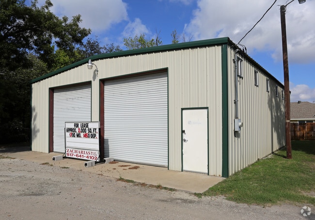


Property Detail
1209 E Henderson St
Dallas-Fort Worth-Arlington, TX
LOT 4R BLK 354/4 ORIGINAL CLEBURNE /AKA CHOATE ADDN
126-2800-19414
Johnson
Commercialnec
Texas
B and X Area of moderate flood hazard, usually the area between the limits of the 100-year and 500-year floods.
4r
2024
0.36 AC
2025
Johnson County
130900
Dallas/Ft Worth
1,140 SF
NEARBY LISTINGS FOR SALE OR LEASE
DEMOGRAPHICS near 1209 E Henderson St
1 mile
3 mile
5 mile
2025 Total Population
3,985
31,623
52,440
2030 Population
4,615
36,086
59,927
Pop Growth 2025-2030
+ 15.81%
+ 14.11%
+ 14.28%
Average Age
35
38
38
2025 Total Households
1,261
10,898
18,297
HH Growth 2025-2030
+ 15.46%
+ 13.76%
+ 13.97%
Median Household Inc
$55,077
$63,675
$68,668
Avg Household Size
3.00
2.70
2.70
2025 Avg HH Vehicles
2.00
2.00
2.00
Median Home Value
$110,317
$206,678
$244,441
Median Year Built
1975
1980
1985
Nearby Places
Map Layers
Map Styles
 Street
 Aerial
Layers
 Traffic
 Biking
Places
Listings with unknown addresses are not visible on the map
- Restaurants
- Banks
- Shops
- Fitness
- Groceries
PUBLIC TRANSPORTATION
COMMUTER RAIL
Cleburne Amtrak Station (Texas Eagle - Amtrak)
Drive
Walk
Distance
Cleburne Amtrak Station (Texas Eagle - Amtrak)
2 min
19 min
1.0 mi
Freight Ports
Port of Shreveport
Drive
Walk
Distance
Port of Shreveport
259 min
238.8 mi
SALE & LEASE HISTORY
LISTING DATE
SALE/LEASE

Sep 28, 2016
For Lease
Nearby Properties
Address
Land Use
TOTAL SIZE
Lot Size
Zoning
Address
Land Use
TOTAL SIZE
Lot Size
Zoning
81,253 SF
3.51 AC
Address
Land Use
TOTAL SIZE
Lot Size
Zoning
26,932 SF
17.62 AC
Address
Land Use
TOTAL SIZE
Lot Size
Zoning
1.01 AC
Address
Land Use
TOTAL SIZE
Lot Size
Zoning
Address
Land Use
TOTAL SIZE
Lot Size
Zoning
69,592 SF
29.56 AC
Address
Land Use
TOTAL SIZE
Lot Size
Zoning
74,275 SF
23.13 AC
Address
Land Use
TOTAL SIZE
Lot Size
Zoning
67,699 SF
43.74 AC
Address
Land Use
TOTAL SIZE
Lot Size
Zoning
67,564 SF
11 AC
Address
Land Use
TOTAL SIZE
Lot Size
Zoning
24.44 AC
Address
Land Use
TOTAL SIZE
Lot Size
Zoning
207,010 SF
25.39 AC
Address
Land Use
TOTAL SIZE
Lot Size
Zoning
668,640 SF
0.08 AC
Address
Land Use
TOTAL SIZE
Lot Size
Zoning
1 SF
35.23 AC
Address
Land Use
TOTAL SIZE
Lot Size
Zoning
90.80 AC
Address
Land Use
TOTAL SIZE
Lot Size
Zoning
3,264 SF
6.63 AC
Address
Land Use
TOTAL SIZE
Lot Size
Zoning
12,000 SF
5.54 AC
Address
Land Use
TOTAL SIZE
Lot Size
Zoning
68,230 SF
8.15 AC
Address
Land Use
TOTAL SIZE
Lot Size
Zoning
Address
Land Use
TOTAL SIZE
Lot Size
Zoning
143,327 SF
20 AC
Address
Land Use
TOTAL SIZE
Lot Size
Zoning
129,408 SF
16.72 AC
Address
Land Use
TOTAL SIZE
Lot Size
Zoning
29,553 SF
7.93 AC
Address
Land Use
TOTAL SIZE
Lot Size
Zoning
82,669 SF
11.50 AC
Address
Land Use
TOTAL SIZE
Lot Size
Zoning
175.06 AC
Address
Land Use
TOTAL SIZE
Lot Size
Zoning
43,070 SF
7.57 AC
Address
Land Use
TOTAL SIZE
Lot Size
Zoning
3.74 AC
Address
Land Use
TOTAL SIZE
Lot Size
Zoning
16,003 SF
10.55 AC
Address
Land Use
TOTAL SIZE
Lot Size
Zoning
109,045 SF
12.09 AC
Address
Land Use
TOTAL SIZE
Lot Size
Zoning
272.03 AC
Address
Land Use
TOTAL SIZE
Lot Size
Zoning
45,683 SF
3.57 AC
Address
Land Use
TOTAL SIZE
Lot Size
Zoning
20,246 SF
10.91 AC
Address
Land Use
TOTAL SIZE
Lot Size
Zoning
43,190 SF
23.23 AC
The World's #1 Commercial Real Estate Marketplace
Connect with us
© 2026 CoStar Group
The information above has been obtained from sources believed reliable. While we do not doubt its accuracy we have not verified it and make no guarantee, warranty or representation about it. It is your responsibility to independently confirm its accuracy and completeness. Any projections, opinions, assumptions, or estimates used are for example only and do not represent the current or future performance of the property. The value of this transaction to you depends on tax and other factors which should be evaluated by your tax, financial, and legal advisors. You and your advisors should conduct a careful, independent investigation of the property to determine to your satisfaction the suitability of the property for your needs.