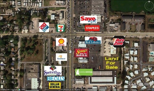
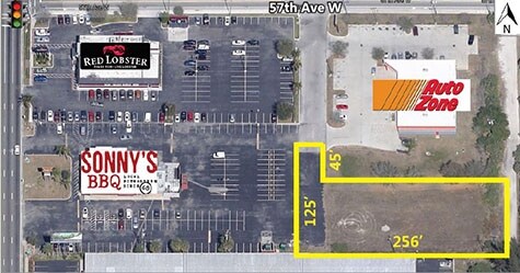
Property Record
1210 57Th Ave W, Bradenton, FL 34207

Property Detail
1210 57Th Ave W
59927-1025-9
THAT PART OF THE NW 1/4 LESS THE S 200 FT OF THE NE 1/4 OF THE SW 1/4 OF SEC 14, FURTHER DESC AS FOLLOWS: BEG AT A PT OF INT WITH THE E R/W LN OF U.S. 41 & THE S R/W LN OF LITTLE
Storemultistory
Manatee
GC GENERA
Florida
B and X Area of moderate flood hazard, usually the area between the limits of the 100-year and 500-year floods.
2.79 AC
2024
Manatee
2025
Tampa/St Petersburg
000314
North Port-Bradenton-Sarasota, FL
20,313 SF
NEARBY LISTINGS FOR SALE OR LEASE
DEMOGRAPHICS near 1210 57Th Ave W
1 mile
3 mile
5 mile
2025 Total Population
22,425
106,081
196,560
2030 Population
25,124
118,163
218,752
Pop Growth 2025-2030
+ 12.04%
+ 11.39%
+ 11.29%
Average Age
44
44
45
2025 Total Households
10,015
45,762
84,754
HH Growth 2025-2030
+ 12.32%
+ 11.89%
+ 11.68%
Median Household Inc
$42,883
$52,139
$60,015
Avg Household Size
2.10
2.20
2.20
2025 Avg HH Vehicles
1.00
1.00
2.00
Median Home Value
$110,199
$195,608
$289,224
Median Year Built
1974
1978
1981
Nearby Places
Map Layers
Map Styles
 Street
 Aerial
Layers
 Traffic
 Biking
Places
Listings with unknown addresses are not visible on the map
- Restaurants
- Banks
- Shops
- Fitness
- Groceries
PUBLIC TRANSPORTATION
AIRPORT
Sarasota/Bradenton International
Drive
Walk
Distance
Sarasota/Bradenton International
7 min
3.6 mi
Freight Ports
Port Manatee
Drive
Walk
Distance
Port Manatee
28 min
15.8 mi
SALE & LEASE HISTORY
LISTING DATE
SALE/LEASE

Jan 31, 2017
For Sale
Nearby Properties
Address
Land Use
TOTAL SIZE
Lot Size
Zoning
Address
Land Use
TOTAL SIZE
Lot Size
Zoning
623,436 SF
88.25 AC
PD-R,MP-I
Address
Land Use
TOTAL SIZE
Lot Size
Zoning
437,460 SF
46.14 AC
PD-R
Address
Land Use
TOTAL SIZE
Lot Size
Zoning
456,263 SF
28.02 AC
BR_R-3
Address
Land Use
TOTAL SIZE
Lot Size
Zoning
314,018 SF
28.20 AC
BR_R-3
Address
Land Use
TOTAL SIZE
Lot Size
Zoning
645,805 SF
91.21 AC
PD-PI
Address
Land Use
TOTAL SIZE
Lot Size
Zoning
507,194 SF
8.49 AC
Address
Land Use
TOTAL SIZE
Lot Size
Zoning
247,280 SF
17.72 AC
PD-R
Address
Land Use
TOTAL SIZE
Lot Size
Zoning
294,609 SF
19.15 AC
RMF9
Address
Land Use
TOTAL SIZE
Lot Size
Zoning
117,547 SF
11.64 AC
MP-I
Address
Land Use
TOTAL SIZE
Lot Size
Zoning
153,663 SF
110.35 AC
MP-I
Address
Land Use
TOTAL SIZE
Lot Size
Zoning
375,171 SF
20 AC
PD-MU
Address
Land Use
TOTAL SIZE
Lot Size
Zoning
214,906 SF
20.71 AC
BR_R-1
Address
Land Use
TOTAL SIZE
Lot Size
Zoning
500,923 SF
47.91 AC
Address
Land Use
TOTAL SIZE
Lot Size
Zoning
397,863 SF
21.60 AC
GC GENERA
Address
Land Use
TOTAL SIZE
Lot Size
Zoning
335,019 SF
32.58 AC
BR_R-3
Address
Land Use
TOTAL SIZE
Lot Size
Zoning
247,592 SF
13.39 AC
GC,RMF-6
Address
Land Use
TOTAL SIZE
Lot Size
Zoning
198,036 SF
8.32 AC
GC GENERA
Address
Land Use
TOTAL SIZE
Lot Size
Zoning
331,144 SF
40.48 AC
PD-PI
Address
Land Use
TOTAL SIZE
Lot Size
Zoning
115,400 SF
22.55 AC
LM LIGHT M
Address
Land Use
TOTAL SIZE
Lot Size
Zoning
159,960 SF
11.30 AC
RMF-9 MULT
Address
Land Use
TOTAL SIZE
Lot Size
Zoning
185,617 SF
13.68 AC
BR_R-2
Address
Land Use
TOTAL SIZE
Lot Size
Zoning
359,950 SF
34.91 AC
LM LIGHT M
Address
Land Use
TOTAL SIZE
Lot Size
Zoning
187,000 SF
8.93 AC
Address
Land Use
TOTAL SIZE
Lot Size
Zoning
214,350 SF
16.07 AC
LM LIGHT M
Address
Land Use
TOTAL SIZE
Lot Size
Zoning
296,983 SF
34.84 AC
PD-MU
Address
Land Use
TOTAL SIZE
Lot Size
Zoning
485,150 SF
56.44 AC
HC,GC
Address
Land Use
TOTAL SIZE
Lot Size
Zoning
163,394 SF
15.49 AC
PD-MU
Address
Land Use
TOTAL SIZE
Lot Size
Zoning
179,650 SF
10.63 AC
RMF-9 MULT
Address
Land Use
TOTAL SIZE
Lot Size
Zoning
179,042 SF
6.60 AC
PD-MU
Address
Land Use
TOTAL SIZE
Lot Size
Zoning
318,009 SF
34.60 AC
LM LIGHT M
The World's #1 Commercial Real Estate Marketplace
Connect with us
© 2026 CoStar Group
The information above has been obtained from sources believed reliable. While we do not doubt its accuracy we have not verified it and make no guarantee, warranty or representation about it. It is your responsibility to independently confirm its accuracy and completeness. Any projections, opinions, assumptions, or estimates used are for example only and do not represent the current or future performance of the property. The value of this transaction to you depends on tax and other factors which should be evaluated by your tax, financial, and legal advisors. You and your advisors should conduct a careful, independent investigation of the property to determine to your satisfaction the suitability of the property for your needs.