Property Record
1210 Rio Wild Dr, Raleigh, NC 27614


NEARBY LISTINGS FOR SALE OR LEASE
-
-
View all Raleigh listings for sale on LoopNet.com
Property Detail
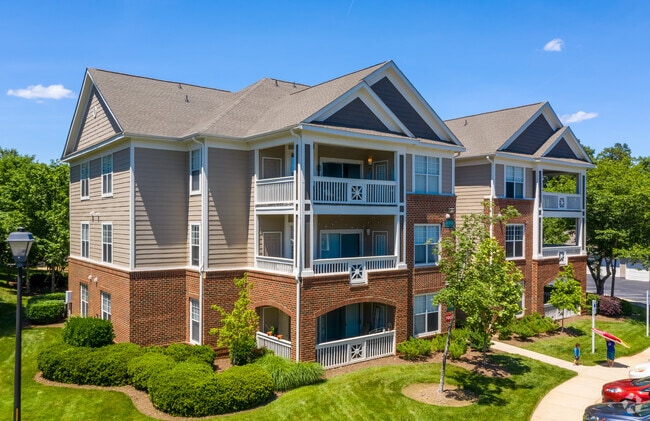
1210 Rio Wild Dr
Raleigh, NC
Alta Acsm Land Title Survey For Wp River
1728.01-06-2222-000
LO12 RECOMB ALTON SMITH PROP BM1999-1923
Apartment
Wake
X
North Carolina
3720172800K
12
2025
20.15 AC
2025
North Raleigh
054019
Raleigh/Durham
317,685 SF
DEMOGRAPHICS near 1210 Rio Wild Dr
1 Mile
3 Mile
5 Mile
2024 Total Population
7,844
51,199
168,317
2029 Population
8,451
55,311
182,595
Pop Growth 2024-2029
+ 7.74%
+ 8.03%
+ 8.48%
Average Age
41
40
40
2024 Total Households
3,193
20,428
68,841
HH Growth 2024-2029
+ 7.74%
+ 8.08%
+ 8.50%
Median Household Inc
$124,731
$96,571
$83,173
Avg Household Size
2.40
2.50
2.40
2024 Avg HH Vehicles
2.00
2.00
2.00
Median Home Value
$393,921
$389,627
$361,279
Median Year Built
1997
1998
1995
Nearby Places
Map Layers
Map Styles
 Street
 Aerial
- Restaurants
- Banks
- Shops
- Fitness
- Groceries
PUBLIC TRANSPORTATION
AIRPORT
Raleigh-Durham International
DRIVE
WALK
Distance
Raleigh-Durham International
20 min
14.2 mi
Freight Ports
Port of Wilmington
DRIVE
WALK
Distance
Port of Wilmington
169 min
143.1 mi
Nearby Properties
Address
Land Use
TOTAL SIZE
Lot Size
Zoning
Address
Land Use
TOTAL SIZE
Lot Size
Zoning
7,128 SF
17,955.26 AC
R-80W
Address
Land Use
TOTAL SIZE
Lot Size
Zoning
497,619 SF
109.80 AC
R-6
Address
Land Use
TOTAL SIZE
Lot Size
Zoning
1,125,127 SF
104.26 AC
R-1
Address
Land Use
TOTAL SIZE
Lot Size
Zoning
342,900 SF
19.15 AC
RX-3
Address
Land Use
TOTAL SIZE
Lot Size
Zoning
402,163 SF
23.39 AC
RX-3
Address
Land Use
TOTAL SIZE
Lot Size
Zoning
241,800 SF
14.83 AC
OX-5
Address
Land Use
TOTAL SIZE
Lot Size
Zoning
328,816 SF
17.95 AC
CX-5
Address
Land Use
TOTAL SIZE
Lot Size
Zoning
382,781 SF
52.73 AC
CX-3
Address
Land Use
TOTAL SIZE
Lot Size
Zoning
357,933 SF
16.02 AC
PD
Address
Land Use
TOTAL SIZE
Lot Size
Zoning
285,949 SF
32.91 AC
RX-3
Address
Land Use
TOTAL SIZE
Lot Size
Zoning
310,757 SF
38.38 AC
R-10
Address
Land Use
TOTAL SIZE
Lot Size
Zoning
274,175 SF
12.74 AC
CX-5
Address
Land Use
TOTAL SIZE
Lot Size
Zoning
245,352 SF
28.53 AC
R-10
Address
Land Use
TOTAL SIZE
Lot Size
Zoning
270,618 SF
30.39 AC
R-10
Address
Land Use
TOTAL SIZE
Lot Size
Zoning
77,921 SF
33 AC
IX-3
Address
Land Use
TOTAL SIZE
Lot Size
Zoning
177,165 SF
9.74 AC
OX-4
Address
Land Use
TOTAL SIZE
Lot Size
Zoning
203,316 SF
10.64 AC
R-10
Address
Land Use
TOTAL SIZE
Lot Size
Zoning
243,354 SF
19.90 AC
R-10
Address
Land Use
TOTAL SIZE
Lot Size
Zoning
94,751 SF
66.71 AC
IX-3
Address
Land Use
TOTAL SIZE
Lot Size
Zoning
191,894 SF
14.49 AC
R-10
Address
Land Use
TOTAL SIZE
Lot Size
Zoning
106,730 SF
11.73 AC
IX-3
Address
Land Use
TOTAL SIZE
Lot Size
Zoning
141,674 SF
8.31 AC
RX-4
Address
Land Use
TOTAL SIZE
Lot Size
Zoning
147,275 SF
34.22 AC
R-4
Address
Land Use
TOTAL SIZE
Lot Size
Zoning
139,376 SF
4.80 AC
NX-4
Address
Land Use
TOTAL SIZE
Lot Size
Zoning
130,697 SF
40 AC
R-4
Address
Land Use
TOTAL SIZE
Lot Size
Zoning
236,651 SF
13.30 AC
IX-3
Address
Land Use
TOTAL SIZE
Lot Size
Zoning
85,312 SF
21.37 AC
HB
Address
Land Use
TOTAL SIZE
Lot Size
Zoning
184,840 SF
OX-5
Address
Land Use
TOTAL SIZE
Lot Size
Zoning
107,852 SF
14.11 AC
CX-3
The World's #1 Commercial Real Estate Marketplace
Connect with us
© 2026 CoStar Group
The information above has been obtained from sources believed reliable. While we do not doubt its accuracy we have not verified it and make no guarantee, warranty or representation about it. It is your responsibility to independently confirm its accuracy and completeness. Any projections, opinions, assumptions, or estimates used are for example only and do not represent the current or future performance of the property. The value of this transaction to you depends on tax and other factors which should be evaluated by your tax, financial, and legal advisors. You and your advisors should conduct a careful, independent investigation of the property to determine to your satisfaction the suitability of the property for your needs.