Property Record
1211 Newcastle St, Beaufort, SC 29902


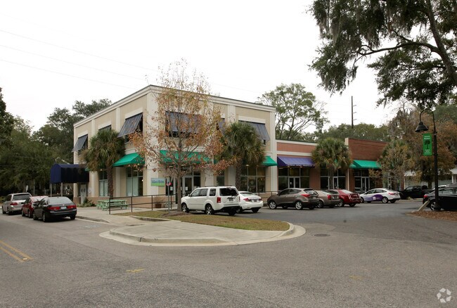
Property Detail
1211 Newcastle St
Hilton Head Island-Bluffton-Port Royal, SC
LOTS 102-107,120-125 RIVER ADDITION S/D PB77 P104 12/04 ESMT GRANTED DB2068/1847
R120-004-000-0021-0000
Beaufort
Stripcommercialcenter
South Carolina
6611
102-107
2025
2.03 AC
2025
Hilton Head/Beaufort
000600
Other Market Areas
28,570 SF
NEARBY LISTINGS FOR SALE OR LEASE
DEMOGRAPHICS near 1211 Newcastle St
1 mile
3 mile
5 mile
2025 Total Population
3,005
18,137
37,839
2030 Population
3,164
18,889
39,447
Pop Growth 2025-2030
+ 5.29%
+ 4.15%
+ 4.25%
Average Age
46
43
41
2025 Total Households
1,416
7,614
14,854
HH Growth 2025-2030
+ 5.65%
+ 4.36%
+ 4.58%
Median Household Inc
$47,518
$74,403
$73,273
Avg Household Size
2.10
2.30
2.30
2025 Avg HH Vehicles
2.00
2.00
2.00
Median Home Value
$384,809
$393,879
$374,930
Median Year Built
1958
1991
1992
Nearby Places
Map Layers
Map Styles
 Street
 Aerial
Layers
 Traffic
 Biking
Places
Listings with unknown addresses are not visible on the map
- Restaurants
- Banks
- Shops
- Fitness
- Groceries
PUBLIC TRANSPORTATION
AIRPORT
Hilton Head
Drive
Walk
Distance
Hilton Head
51 min
38.3 mi
Freight Ports
Georgia Ports - Savannah
Drive
Walk
Distance
Georgia Ports - Savannah
61 min
47.7 mi
Nearby Properties
Address
Land Use
TOTAL SIZE
Lot Size
Zoning
Address
Land Use
TOTAL SIZE
Lot Size
Zoning
308,567 SF
26.58 AC
Address
Land Use
TOTAL SIZE
Lot Size
Zoning
252,178 SF
19.36 AC
6601
Address
Land Use
TOTAL SIZE
Lot Size
Zoning
240,395 SF
4.45 AC
6601
Address
Land Use
TOTAL SIZE
Lot Size
Zoning
148,706 SF
16.27 AC
6612
Address
Land Use
TOTAL SIZE
Lot Size
Zoning
56,139 SF
6.97 AC
6611
Address
Land Use
TOTAL SIZE
Lot Size
Zoning
101,304 SF
6.47 AC
6611
Address
Land Use
TOTAL SIZE
Lot Size
Zoning
75,973 SF
2.05 AC
6611
Address
Land Use
TOTAL SIZE
Lot Size
Zoning
56,043 SF
4.18 AC
6601
Address
Land Use
TOTAL SIZE
Lot Size
Zoning
144,226 SF
41.30 AC
6611
Address
Land Use
TOTAL SIZE
Lot Size
Zoning
116,067 SF
27 AC
6611
Address
Land Use
TOTAL SIZE
Lot Size
Zoning
87,456 SF
4.76 AC
6611
Address
Land Use
TOTAL SIZE
Lot Size
Zoning
60,814 SF
3 AC
Address
Land Use
TOTAL SIZE
Lot Size
Zoning
87,884 SF
4.16 AC
6611
Address
Land Use
TOTAL SIZE
Lot Size
Zoning
134,446 SF
19.90 AC
6611
Address
Land Use
TOTAL SIZE
Lot Size
Zoning
3,304 SF
7.50 AC
6611
Address
Land Use
TOTAL SIZE
Lot Size
Zoning
57,117 SF
2.03 AC
Address
Land Use
TOTAL SIZE
Lot Size
Zoning
71,309 SF
2.30 AC
6601
Address
Land Use
TOTAL SIZE
Lot Size
Zoning
44,312 SF
1.87 AC
Address
Land Use
TOTAL SIZE
Lot Size
Zoning
52,322 SF
6.86 AC
6601
Address
Land Use
TOTAL SIZE
Lot Size
Zoning
75,233 SF
19.91 AC
6612
Address
Land Use
TOTAL SIZE
Lot Size
Zoning
113,068 SF
12.55 AC
6611
Address
Land Use
TOTAL SIZE
Lot Size
Zoning
1,088 SF
6.67 AC
9999
Address
Land Use
TOTAL SIZE
Lot Size
Zoning
36,020 SF
3.46 AC
6611
Address
Land Use
TOTAL SIZE
Lot Size
Zoning
32,035 SF
7.39 AC
4201
Address
Land Use
TOTAL SIZE
Lot Size
Zoning
35,734 SF
5.80 AC
6611
Address
Land Use
TOTAL SIZE
Lot Size
Zoning
48,288 SF
5.70 AC
6611
Address
Land Use
TOTAL SIZE
Lot Size
Zoning
Address
Land Use
TOTAL SIZE
Lot Size
Zoning
60,696 SF
0.62 AC
6611
Address
Land Use
TOTAL SIZE
Lot Size
Zoning
64,150 SF
8.75 AC
6612
The World's #1 Commercial Real Estate Marketplace
Connect with us
© 2026 CoStar Group
The information above has been obtained from sources believed reliable. While we do not doubt its accuracy we have not verified it and make no guarantee, warranty or representation about it. It is your responsibility to independently confirm its accuracy and completeness. Any projections, opinions, assumptions, or estimates used are for example only and do not represent the current or future performance of the property. The value of this transaction to you depends on tax and other factors which should be evaluated by your tax, financial, and legal advisors. You and your advisors should conduct a careful, independent investigation of the property to determine to your satisfaction the suitability of the property for your needs.