Property Record
12190 W Branch Crossing Dr, Spring, TX 77382
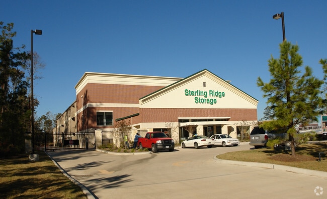

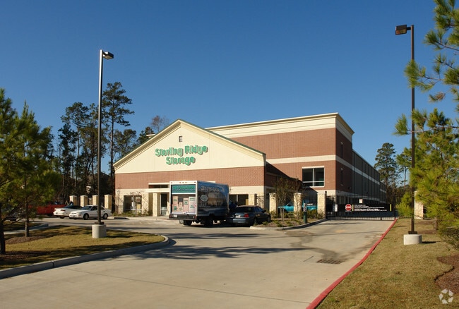
Property Detail
12190 W Branch Crossing Dr
9699-70-00100
S969970 - WDLNDS VIL STERLING RIDGE 70, BLOCK 1, RES A, ACRES 2.839
Commercialnec
MONTGOMERY
B and X Area of moderate flood hazard, usually the area between the limits of the 100-year and 500-year floods.
Texas
2024
2.84 AC
2025
The Woodlands
690604
Houston
105,005 SF
Houston-Pasadena-The Woodlands, TX
NEARBY LISTINGS FOR SALE OR LEASE
-
-
View all Spring listings for sale on LoopNet.com
DEMOGRAPHICS near 12190 W Branch Crossing Dr
1 mile
3 mile
5 mile
2025 Total Population
12,511
49,610
124,212
2030 Population
14,447
57,845
142,385
Pop Growth 2025-2030
+ 15.47%
+ 16.60%
+ 14.63%
Average Age
36
38
39
2025 Total Households
4,396
16,477
42,487
HH Growth 2025-2030
+ 16.06%
+ 17.16%
+ 15.20%
Median Household Inc
$118,627
$133,277
$139,810
Avg Household Size
2.80
3.00
2.90
2025 Avg HH Vehicles
2.00
2.00
2.00
Median Home Value
$587,994
$510,621
$494,357
Median Year Built
2008
2007
2006
Nearby Places
Map Layers
Map Styles
 Street
 Aerial
Layers
 Traffic
 Biking
Places
Listings with unknown addresses are not visible on the map
- Restaurants
- Banks
- Shops
- Fitness
- Groceries
PUBLIC TRANSPORTATION
AIRPORT
George Bush Intcntl/Houston
Drive
Walk
Distance
George Bush Intcntl/Houston
41 min
29.5 mi
Freight Ports
Port of Houston
Drive
Walk
Distance
Port of Houston
64 min
45.2 mi
Nearby Properties
Address
Land Use
TOTAL SIZE
Lot Size
Zoning
Address
Land Use
TOTAL SIZE
Lot Size
Zoning
461,345 SF
28.36 AC
Address
Land Use
TOTAL SIZE
Lot Size
Zoning
370,029 SF
16.12 AC
Address
Land Use
TOTAL SIZE
Lot Size
Zoning
361,747 SF
16.71 AC
Address
Land Use
TOTAL SIZE
Lot Size
Zoning
296,538 SF
12.58 AC
Address
Land Use
TOTAL SIZE
Lot Size
Zoning
194,272 SF
11.06 AC
Address
Land Use
TOTAL SIZE
Lot Size
Zoning
289,611 SF
13.57 AC
Address
Land Use
TOTAL SIZE
Lot Size
Zoning
222,687 SF
8.03 AC
2
Address
Land Use
TOTAL SIZE
Lot Size
Zoning
198,969 SF
32.78 AC
Address
Land Use
TOTAL SIZE
Lot Size
Zoning
211,965 SF
25.17 AC
Address
Land Use
TOTAL SIZE
Lot Size
Zoning
61,218 SF
9.30 AC
Address
Land Use
TOTAL SIZE
Lot Size
Zoning
172,784 SF
20.60 AC
2
Address
Land Use
TOTAL SIZE
Lot Size
Zoning
190,000 SF
24.21 AC
Address
Land Use
TOTAL SIZE
Lot Size
Zoning
165,218 SF
17.40 AC
2
Address
Land Use
TOTAL SIZE
Lot Size
Zoning
51,134 SF
25 AC
2
Address
Land Use
TOTAL SIZE
Lot Size
Zoning
133,266 SF
2.95 AC
2
Address
Land Use
TOTAL SIZE
Lot Size
Zoning
1,440 SF
126.83 AC
2
Address
Land Use
TOTAL SIZE
Lot Size
Zoning
106,520 SF
14.16 AC
Address
Land Use
TOTAL SIZE
Lot Size
Zoning
212,968 SF
24.36 AC
Address
Land Use
TOTAL SIZE
Lot Size
Zoning
126,535 SF
11.94 AC
Address
Land Use
TOTAL SIZE
Lot Size
Zoning
116,619 SF
14 AC
Address
Land Use
TOTAL SIZE
Lot Size
Zoning
47.19 AC
Address
Land Use
TOTAL SIZE
Lot Size
Zoning
118,359 SF
14.15 AC
Address
Land Use
TOTAL SIZE
Lot Size
Zoning
43,510 SF
5.63 AC
Address
Land Use
TOTAL SIZE
Lot Size
Zoning
105,416 SF
11.45 AC
Address
Land Use
TOTAL SIZE
Lot Size
Zoning
88,739 SF
7.26 AC
Address
Land Use
TOTAL SIZE
Lot Size
Zoning
37,764 SF
15.71 AC
Address
Land Use
TOTAL SIZE
Lot Size
Zoning
99,623 SF
14.45 AC
2
Address
Land Use
TOTAL SIZE
Lot Size
Zoning
50,474 SF
4.71 AC
Address
Land Use
TOTAL SIZE
Lot Size
Zoning
106,745 SF
2.97 AC
The World's #1 Commercial Real Estate Marketplace
Connect with us
© 2026 CoStar Group
The information above has been obtained from sources believed reliable. While we do not doubt its accuracy we have not verified it and make no guarantee, warranty or representation about it. It is your responsibility to independently confirm its accuracy and completeness. Any projections, opinions, assumptions, or estimates used are for example only and do not represent the current or future performance of the property. The value of this transaction to you depends on tax and other factors which should be evaluated by your tax, financial, and legal advisors. You and your advisors should conduct a careful, independent investigation of the property to determine to your satisfaction the suitability of the property for your needs.