Property Record
122 Monroe Ave, Langhorne, PA 19047


Save to a Folder
{{folder.Name}}
{{folder.ListingIds.length}} Properties
{{folder.ListingIds.length}} Property
Create a New Folder
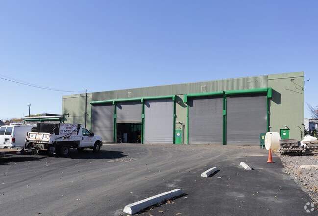
Property Detail
122 Monroe Ave
32-005-038
LOTS #12,14,16,18,20,22 OTTO GRUPP PLAN 338X150
Autorepair
Bucks
RC
Pennsylvania
B and X Area of moderate flood hazard, usually the area between the limits of the 100-year and 500-year floods.
12,14
2025
1.16 AC
2026
Bucks
101100
Philadelphia
11,501 SF
Philadelphia-Camden-Wilmington, PA-NJ-DE-MD
NEARBY LISTINGS FOR SALE OR LEASE
DEMOGRAPHICS near 122 Monroe Ave
1 mile
3 mile
5 mile
2025 Total Population
11,017
84,914
237,045
2030 Population
11,015
84,984
237,856
Pop Growth 2025-2030
(0.02%)
+ 0.08%
+ 0.34%
Average Age
41
43
43
2025 Total Households
4,079
31,803
89,837
HH Growth 2025-2030
0.00%
+ 0.01%
+ 0.28%
Median Household Inc
$96,630
$101,043
$94,836
Avg Household Size
2.50
2.60
2.50
2025 Avg HH Vehicles
2.00
2.00
2.00
Median Home Value
$414,890
$387,598
$379,384
Median Year Built
1965
1971
1971
Nearby Places
Map Layers
Map Styles
 Street
 Aerial
Layers
 Traffic
 Biking
Places
Listings with unknown addresses are not visible on the map
- Restaurants
- Banks
- Shops
- Fitness
- Groceries
PUBLIC TRANSPORTATION
COMMUTER RAIL
Langhorne (West Trenton Line - SEPTA)
Drive
Walk
Distance
Langhorne (West Trenton Line - SEPTA)
0 min
4 min
0.2 mi
Woodbourne (West Trenton Line - SEPTA)
Drive
Walk
Distance
Woodbourne (West Trenton Line - SEPTA)
7 min
3.1 mi
AIRPORT
Trenton Mercer
Drive
Walk
Distance
Trenton Mercer
19 min
11.5 mi
Philadelphia International
Drive
Walk
Distance
Philadelphia International
49 min
31.8 mi
Freight Ports
Port of Philadelphia
Drive
Walk
Distance
Port of Philadelphia
29 min
18.2 mi
Nearby Properties
Address
Land Use
TOTAL SIZE
Lot Size
Zoning
Address
Land Use
TOTAL SIZE
Lot Size
Zoning
271,979 SF
10.96 AC
GB
Address
Land Use
TOTAL SIZE
Lot Size
Zoning
32,912 SF
42.06 AC
AO
Address
Land Use
TOTAL SIZE
Lot Size
Zoning
4,982 SF
39 AC
C
Address
Land Use
TOTAL SIZE
Lot Size
Zoning
759,617 SF
23.82 AC
HC
Address
Land Use
TOTAL SIZE
Lot Size
Zoning
150,000 SF
21.46 AC
R3
Address
Land Use
TOTAL SIZE
Lot Size
Zoning
119,300 SF
2.65 AC
MI
Address
Land Use
TOTAL SIZE
Lot Size
Zoning
282,799 SF
24.77 AC
GB
Address
Land Use
TOTAL SIZE
Lot Size
Zoning
10,025 SF
19.11 AC
CD
Address
Land Use
TOTAL SIZE
Lot Size
Zoning
19.95 AC
CD
Address
Land Use
TOTAL SIZE
Lot Size
Zoning
202,400 SF
20.98 AC
C
Address
Land Use
TOTAL SIZE
Lot Size
Zoning
730,540 SF
82.69 AC
GB
Address
Land Use
TOTAL SIZE
Lot Size
Zoning
267,936 SF
19.22 AC
M1
Address
Land Use
TOTAL SIZE
Lot Size
Zoning
72,540 SF
14.02 AC
CD
Address
Land Use
TOTAL SIZE
Lot Size
Zoning
3,490 SF
15.80 AC
R1
Address
Land Use
TOTAL SIZE
Lot Size
Zoning
171,918 SF
17.70 AC
AO
Address
Land Use
TOTAL SIZE
Lot Size
Zoning
163,779 SF
20.10 AC
MI
Address
Land Use
TOTAL SIZE
Lot Size
Zoning
41,546 SF
11.67 AC
CD
Address
Land Use
TOTAL SIZE
Lot Size
Zoning
37,550 SF
5.18 AC
M1
Address
Land Use
TOTAL SIZE
Lot Size
Zoning
199,758 SF
22.16 AC
HC
Address
Land Use
TOTAL SIZE
Lot Size
Zoning
146,556 SF
30.35 AC
C
Address
Land Use
TOTAL SIZE
Lot Size
Zoning
4,722 SF
14.30 AC
CD
Address
Land Use
TOTAL SIZE
Lot Size
Zoning
124,830 SF
2.83 AC
C
Address
Land Use
TOTAL SIZE
Lot Size
Zoning
93,562 SF
12.60 AC
AO
Address
Land Use
TOTAL SIZE
Lot Size
Zoning
17,570 SF
21.14 AC
AO
Address
Land Use
TOTAL SIZE
Lot Size
Zoning
33,084 SF
11.32 AC
CD
Address
Land Use
TOTAL SIZE
Lot Size
Zoning
26,340 SF
11.82 AC
CD
Address
Land Use
TOTAL SIZE
Lot Size
Zoning
15,905 SF
8.43 AC
M1
Address
Land Use
TOTAL SIZE
Lot Size
Zoning
75,089 SF
2.03 AC
R2
Address
Land Use
TOTAL SIZE
Lot Size
Zoning
91,910 SF
6.05 AC
GB
Address
Land Use
TOTAL SIZE
Lot Size
Zoning
64,548 SF
11.59 AC
R1
The World's #1 Commercial Real Estate Marketplace
Connect with us
© 2026 CoStar Group
The information above has been obtained from sources believed reliable. While we do not doubt its accuracy we have not verified it and make no guarantee, warranty or representation about it. It is your responsibility to independently confirm its accuracy and completeness. Any projections, opinions, assumptions, or estimates used are for example only and do not represent the current or future performance of the property. The value of this transaction to you depends on tax and other factors which should be evaluated by your tax, financial, and legal advisors. You and your advisors should conduct a careful, independent investigation of the property to determine to your satisfaction the suitability of the property for your needs.