Property Record
1220 S Palestine St, Athens, TX 75751
Save to a Folder
{{folder.Name}}
{{folder.ListingIds.length}} Properties
{{folder.ListingIds.length}} Property
Create a New Folder
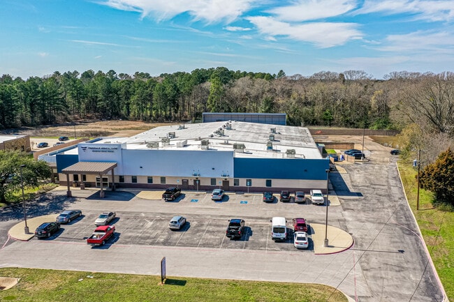
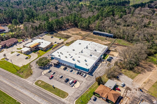
Property Detail
1220 S Palestine St
Athens, TX
HENDERSON
2969-0000-0010-01
Texas
Industrialgeneral
5.61 AC
B and X Area of moderate flood hazard, usually the area between the limits of the 100-year and 500-year floods.
Henderson County
47,204 SF
Dallas/Ft Worth
NEARBY LISTINGS FOR SALE OR LEASE
DEMOGRAPHICS near 1220 S Palestine St
1 mile
3 mile
5 mile
2025 Total Population
3,320
12,467
16,715
2030 Population
3,405
12,813
17,210
Pop Growth 2025-2030
+ 2.56%
+ 2.78%
+ 2.96%
Average Age
42
39
40
2025 Total Households
1,292
4,568
6,212
HH Growth 2025-2030
+ 2.48%
+ 2.63%
+ 2.83%
Median Household Inc
$87,366
$59,421
$58,971
Avg Household Size
2.40
2.50
2.50
2025 Avg HH Vehicles
2.00
2.00
2.00
Median Home Value
$261,999
$214,438
$219,697
Median Year Built
1981
1977
1979
Nearby Places
Map Layers
Map Styles
 Street
 Aerial
Layers
 Traffic
 Biking
Places
Listings with unknown addresses are not visible on the map
- Restaurants
- Banks
- Shops
- Fitness
- Groceries
PUBLIC TRANSPORTATION
AIRPORT
Tyler Pounds Regional
Drive
Walk
Distance
Tyler Pounds Regional
48 min
36.6 mi
Freight Ports
Port of Shreveport
Drive
Walk
Distance
Port of Shreveport
167 min
145.4 mi
SALE & LEASE HISTORY
LISTING DATE
SALE/LEASE

Apr 25, 2017
For Lease
Nearby Properties
Address
Land Use
TOTAL SIZE
Lot Size
Zoning
Address
Land Use
TOTAL SIZE
Lot Size
Zoning
119,750 SF
37.85 AC
Address
Land Use
TOTAL SIZE
Lot Size
Zoning
1,197 SF
18.53 AC
Address
Land Use
TOTAL SIZE
Lot Size
Zoning
40.91 AC
Address
Land Use
TOTAL SIZE
Lot Size
Zoning
9.88 AC
Address
Land Use
TOTAL SIZE
Lot Size
Zoning
35.51 AC
Address
Land Use
TOTAL SIZE
Lot Size
Zoning
8.02 AC
Address
Land Use
TOTAL SIZE
Lot Size
Zoning
43,612 SF
15.43 AC
Address
Land Use
TOTAL SIZE
Lot Size
Zoning
702,506 SF
35 AC
Address
Land Use
TOTAL SIZE
Lot Size
Zoning
49,353 SF
37.85 AC
Address
Land Use
TOTAL SIZE
Lot Size
Zoning
14,475 SF
12.39 AC
Address
Land Use
TOTAL SIZE
Lot Size
Zoning
13.89 AC
Address
Land Use
TOTAL SIZE
Lot Size
Zoning
17.50 AC
Address
Land Use
TOTAL SIZE
Lot Size
Zoning
29,984 SF
7.79 AC
Address
Land Use
TOTAL SIZE
Lot Size
Zoning
47,400 SF
15.33 AC
Address
Land Use
TOTAL SIZE
Lot Size
Zoning
69,056 SF
16.02 AC
Address
Land Use
TOTAL SIZE
Lot Size
Zoning
56,433 SF
5.17 AC
Address
Land Use
TOTAL SIZE
Lot Size
Zoning
140,660 SF
36.75 AC
Address
Land Use
TOTAL SIZE
Lot Size
Zoning
104,120 SF
2 AC
Address
Land Use
TOTAL SIZE
Lot Size
Zoning
32,077 SF
0.25 AC
Address
Land Use
TOTAL SIZE
Lot Size
Zoning
83,122 SF
5.42 AC
Address
Land Use
TOTAL SIZE
Lot Size
Zoning
38,975 SF
4.61 AC
Address
Land Use
TOTAL SIZE
Lot Size
Zoning
2.09 AC
Address
Land Use
TOTAL SIZE
Lot Size
Zoning
14,765 SF
110.29 AC
Address
Land Use
TOTAL SIZE
Lot Size
Zoning
40,549 SF
9.36 AC
Address
Land Use
TOTAL SIZE
Lot Size
Zoning
28,963 SF
10.11 AC
Address
Land Use
TOTAL SIZE
Lot Size
Zoning
265,494 SF
10.99 AC
Address
Land Use
TOTAL SIZE
Lot Size
Zoning
48,153 SF
8.68 AC
Address
Land Use
TOTAL SIZE
Lot Size
Zoning
66,395 SF
13.77 AC
Address
Land Use
TOTAL SIZE
Lot Size
Zoning
20,883 SF
4.40 AC
Address
Land Use
TOTAL SIZE
Lot Size
Zoning
22,958 SF
1.94 AC
The World's #1 Commercial Real Estate Marketplace
Connect with us
© 2026 CoStar Group
The information above has been obtained from sources believed reliable. While we do not doubt its accuracy we have not verified it and make no guarantee, warranty or representation about it. It is your responsibility to independently confirm its accuracy and completeness. Any projections, opinions, assumptions, or estimates used are for example only and do not represent the current or future performance of the property. The value of this transaction to you depends on tax and other factors which should be evaluated by your tax, financial, and legal advisors. You and your advisors should conduct a careful, independent investigation of the property to determine to your satisfaction the suitability of the property for your needs.