Property Record
12202 25Th Rd, Flushing, NY 11354
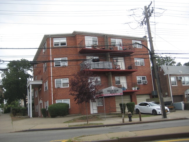

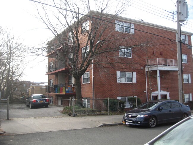
Property Detail
12202 25Th Rd
04260-0025
Queens
Multifamilydwelling
New York
R5B
25
B and X Area of moderate flood hazard, usually the area between the limits of the 100-year and 500-year floods.
0.15 AC
2025
College Point
2026
Long Island (New York)
091900
New York-Jersey City-White Plains, NY-NJ
11,712 SF
NEARBY LISTINGS FOR SALE OR LEASE
DEMOGRAPHICS near 12202 25Th Rd
1 mile
3 mile
5 mile
2025 Total Population
25,669
583,044
1,789,198
2030 Population
24,890
573,594
1,764,792
Pop Growth 2025-2030
(3.03%)
(1.62%)
(1.36%)
Average Age
43
42
41
2025 Total Households
8,032
190,176
639,968
HH Growth 2025-2030
(3.57%)
(1.82%)
(1.58%)
Median Household Inc
$77,658
$69,548
$68,189
Avg Household Size
2.90
2.90
2.60
2025 Avg HH Vehicles
1.00
1.00
1.00
Median Home Value
$569,897
$695,824
$694,242
Median Year Built
1955
1956
1955
Nearby Places
Map Layers
Map Styles
 Street
 Aerial
Layers
 Traffic
 Biking
Places
Listings with unknown addresses are not visible on the map
- Restaurants
- Banks
- Shops
- Fitness
- Groceries
PUBLIC TRANSPORTATION
COMMUTER RAIL
Flushing-Main Street Station (Port Washington Branch - Long Island Rail Road)
Drive
Walk
Distance
Flushing-Main Street Station (Port Washington Branch - Long Island Rail Road)
5 min
1.9 mi
Mets-Willets Point Station (Port Washington Branch - Long Island Rail Road)
Drive
Walk
Distance
Mets-Willets Point Station (Port Washington Branch - Long Island Rail Road)
8 min
2.7 mi
AIRPORT
LaGuardia
Drive
Walk
Distance
LaGuardia
11 min
4.0 mi
John F Kennedy International
Drive
Walk
Distance
John F Kennedy International
17 min
11.6 mi
Newark Liberty International
Drive
Walk
Distance
Newark Liberty International
40 min
30.7 mi
Freight Ports
NY - Red Hook Container Terminal
Drive
Walk
Distance
NY - Red Hook Container Terminal
25 min
14.6 mi
SALE & LEASE HISTORY
LISTING DATE
SALE/LEASE

Nov 01, 2019
For Sale
Nearby Properties
Address
Land Use
TOTAL SIZE
Lot Size
Zoning
Address
Land Use
TOTAL SIZE
Lot Size
Zoning
5,519,372 SF
409.21 AC
C8-2
Address
Land Use
TOTAL SIZE
Lot Size
Zoning
23.16 AC
PARK
Address
Land Use
TOTAL SIZE
Lot Size
Zoning
1,258,350 SF
410.24 AC
PARK
Address
Land Use
TOTAL SIZE
Lot Size
Zoning
332,266 SF
12.57 AC
M2-1
Address
Land Use
TOTAL SIZE
Lot Size
Zoning
426,172 SF
14.30 AC
M3-1
Address
Land Use
TOTAL SIZE
Lot Size
Zoning
577,654 SF
5.38 AC
R6
Address
Land Use
TOTAL SIZE
Lot Size
Zoning
521,944 SF
16.68 AC
R4
Address
Land Use
TOTAL SIZE
Lot Size
Zoning
14,681 SF
97 AC
PARK
Address
Land Use
TOTAL SIZE
Lot Size
Zoning
127,000 SF
16.53 AC
M3-1
Address
Land Use
TOTAL SIZE
Lot Size
Zoning
480,000 SF
16.98 AC
M1-1
Address
Land Use
TOTAL SIZE
Lot Size
Zoning
612,205 SF
10.08 AC
C4-4
Address
Land Use
TOTAL SIZE
Lot Size
Zoning
226,990 SF
0.72 AC
C4-3
Address
Land Use
TOTAL SIZE
Lot Size
Zoning
250,577 SF
23.17 AC
M2-1
Address
Land Use
TOTAL SIZE
Lot Size
Zoning
674,889 SF
51.55 AC
M3-1
Address
Land Use
TOTAL SIZE
Lot Size
Zoning
608,381 SF
4.95 AC
M3-1
Address
Land Use
TOTAL SIZE
Lot Size
Zoning
2,828 SF
78.05 AC
PARK
Address
Land Use
TOTAL SIZE
Lot Size
Zoning
533,460 SF
27.75 AC
M1-1
Address
Land Use
TOTAL SIZE
Lot Size
Zoning
454,631 SF
24.61 AC
M1-1
Address
Land Use
TOTAL SIZE
Lot Size
Zoning
207,407 SF
3.73 AC
R6B
Address
Land Use
TOTAL SIZE
Lot Size
Zoning
251,467 SF
2.02 AC
C4-2
Address
Land Use
TOTAL SIZE
Lot Size
Zoning
456,881 SF
1.43 AC
C4-4
Address
Land Use
TOTAL SIZE
Lot Size
Zoning
15.83 AC
M2-1
Address
Land Use
TOTAL SIZE
Lot Size
Zoning
202,063 SF
2.79 AC
C4-2
Address
Land Use
TOTAL SIZE
Lot Size
Zoning
303,039 SF
C4-2
Address
Land Use
TOTAL SIZE
Lot Size
Zoning
109,805 SF
1.96 AC
C4-2
Address
Land Use
TOTAL SIZE
Lot Size
Zoning
548,113 SF
21.31 AC
M3-1
Address
Land Use
TOTAL SIZE
Lot Size
Zoning
100,000 SF
0.69 AC
R6
Address
Land Use
TOTAL SIZE
Lot Size
Zoning
29,608 SF
33.60 AC
PARK
Address
Land Use
TOTAL SIZE
Lot Size
Zoning
189,197 SF
2.64 AC
R7-1
Address
Land Use
TOTAL SIZE
Lot Size
Zoning
426,224 SF
4.70 AC
R6
The World's #1 Commercial Real Estate Marketplace
Connect with us
© 2026 CoStar Group
The information above has been obtained from sources believed reliable. While we do not doubt its accuracy we have not verified it and make no guarantee, warranty or representation about it. It is your responsibility to independently confirm its accuracy and completeness. Any projections, opinions, assumptions, or estimates used are for example only and do not represent the current or future performance of the property. The value of this transaction to you depends on tax and other factors which should be evaluated by your tax, financial, and legal advisors. You and your advisors should conduct a careful, independent investigation of the property to determine to your satisfaction the suitability of the property for your needs.