Property Record
1225 N Santa Fe Ave, Vista, CA 92084
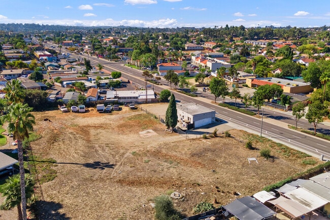


This Property Is For Sale
NEARBY LISTINGS FOR SALE OR LEASE
Property Detail
1225 N Santa Fe Ave
San Diego-Carlsbad, CA
Vista Tract #78-13
173-091-28
PAR A (EX ST) TR PM08186
Storesoffices
San Diego
AE
California
06073C0778G
1.19 AC
2024
Vista
2025
San Diego
019206
DEMOGRAPHICS near 1225 N Santa Fe Ave
1 Mile
3 Mile
5 Mile
2024 Total Population
30,619
118,311
240,552
2029 Population
30,396
117,293
238,270
Pop Growth 2024-2029
(0.73%)
(0.86%)
(0.95%)
Average Age
35
38
40
2024 Total Households
8,328
37,109
79,965
HH Growth 2024-2029
(0.91%)
(1.09%)
(1.14%)
Median Household Inc
$70,374
$91,368
$90,941
Avg Household Size
3.40
3.00
2.90
2024 Avg HH Vehicles
2.00
2.00
2.00
Median Home Value
$544,218
$683,143
$686,557
Median Year Built
1977
1981
1984
Nearby Places
Map Layers
Map Styles
 Street
 Aerial
- Restaurants
- Banks
- Shops
- Fitness
- Groceries
PUBLIC TRANSPORTATION
TRANSIT/SUBWAY
Vista Transit Center (Sprinter - San Diego North County Transit District (Coaster/Sprinter/Breeze))
DRIVE
WALK
Distance
Vista Transit Center (Sprinter - San Diego North County Transit District (Coaster/Sprinter/Breeze))
3 min
18 min
1.0 mi
COMMUTER RAIL
Carlsbad Village (Coaster - San Diego North County Transit District (Coaster/Sprinter/Breeze))
DRIVE
WALK
Distance
Carlsbad Village (Coaster - San Diego North County Transit District (Coaster/Sprinter/Breeze))
16 min
9.6 mi
AIRPORT
San Diego International
DRIVE
WALK
Distance
San Diego International
53 min
41.6 mi
Freight Ports
Port of San Diego
DRIVE
WALK
Distance
Port of San Diego
58 min
45.1 mi
Nearby Properties
Address
Land Use
TOTAL SIZE
Lot Size
Zoning
Address
Land Use
TOTAL SIZE
Lot Size
Zoning
20.10 AC
M-U
Address
Land Use
TOTAL SIZE
Lot Size
Zoning
10.39 AC
M-U (40)
Address
Land Use
TOTAL SIZE
Lot Size
Zoning
11.17 AC
M-U
Address
Land Use
TOTAL SIZE
Lot Size
Zoning
38.61 AC
PD-1 (IL)
Address
Land Use
TOTAL SIZE
Lot Size
Zoning
21.44 AC
C-1
Address
Land Use
TOTAL SIZE
Lot Size
Zoning
1.23 AC
SPI
Address
Land Use
TOTAL SIZE
Lot Size
Zoning
7.97 AC
SPI-DV
Address
Land Use
TOTAL SIZE
Lot Size
Zoning
7.57 AC
R-M
Address
Land Use
TOTAL SIZE
Lot Size
Zoning
5.10 AC
R-M
Address
Land Use
TOTAL SIZE
Lot Size
Zoning
6.87 AC
CN-SP-EQ
Address
Land Use
TOTAL SIZE
Lot Size
Zoning
9.48 AC
R-M
Address
Land Use
TOTAL SIZE
Lot Size
Zoning
14.08 AC
RH
Address
Land Use
TOTAL SIZE
Lot Size
Zoning
8.67 AC
R-M
Address
Land Use
TOTAL SIZE
Lot Size
Zoning
10.38 AC
R-M
Address
Land Use
TOTAL SIZE
Lot Size
Zoning
6.55 AC
R-M
Address
Land Use
TOTAL SIZE
Lot Size
Zoning
65,156 SF
2.52 AC
PD-1 (IL)
Address
Land Use
TOTAL SIZE
Lot Size
Zoning
3.32 AC
SPI
Address
Land Use
TOTAL SIZE
Lot Size
Zoning
10.59 AC
RH
Address
Land Use
TOTAL SIZE
Lot Size
Zoning
3.99 AC
M-U
Address
Land Use
TOTAL SIZE
Lot Size
Zoning
1.92 AC
C-2
Address
Land Use
TOTAL SIZE
Lot Size
Zoning
25.57 AC
C-2
Address
Land Use
TOTAL SIZE
Lot Size
Zoning
4.34 AC
SP-08
Address
Land Use
TOTAL SIZE
Lot Size
Zoning
74,866 SF
3.18 AC
C-1
Address
Land Use
TOTAL SIZE
Lot Size
Zoning
7.18 AC
R-M
Address
Land Use
TOTAL SIZE
Lot Size
Zoning
99,906 SF
5.06 AC
R-M
Address
Land Use
TOTAL SIZE
Lot Size
Zoning
14.67 AC
R-M
Address
Land Use
TOTAL SIZE
Lot Size
Zoning
59,481 SF
2.63 AC
C-1
Address
Land Use
TOTAL SIZE
Lot Size
Zoning
60,200 SF
3.08 AC
R-M
Address
Land Use
TOTAL SIZE
Lot Size
Zoning
77,084 SF
2.12 AC
SPI
Address
Land Use
TOTAL SIZE
Lot Size
Zoning
57,489 SF
6.49 AC
PD-1 (IL)
The World's #1 Commercial Real Estate Marketplace
Connect with us
© 2025 CoStar Group
The information above has been obtained from sources believed reliable. While we do not doubt its accuracy we have not verified it and make no guarantee, warranty or representation about it. It is your responsibility to independently confirm its accuracy and completeness. Any projections, opinions, assumptions, or estimates used are for example only and do not represent the current or future performance of the property. The value of this transaction to you depends on tax and other factors which should be evaluated by your tax, financial, and legal advisors. You and your advisors should conduct a careful, independent investigation of the property to determine to your satisfaction the suitability of the property for your needs.