Property Record
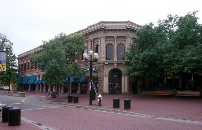
1236 Pearl St, Boulder, CO 80302
Property Detail
1236 Pearl St
Boulder, CO
E 1/2 LOT 2 BLK 67 BOULDER O T
1463303-38-003
BOULDER
Financialbuilding
Colorado
B and X Area of moderate flood hazard, usually the area between the limits of the 100-year and 500-year floods.
2
2024
0.17 AC
2025
Boulder
012204
Denver
NEARBY LISTINGS FOR SALE OR LEASE
DEMOGRAPHICS near 1236 Pearl St
1 mile
3 mile
5 mile
2025 Total Population
24,729
95,577
116,488
2030 Population
24,795
95,657
116,365
Pop Growth 2025-2030
+ 0.27%
+ 0.08%
(0.11%)
Average Age
35
36
38
2025 Total Households
10,571
38,024
47,064
HH Growth 2025-2030
+ 0.26%
+ 0.18%
(0.07%)
Median Household Inc
$58,405
$72,542
$80,656
Avg Household Size
2.00
2.10
2.10
2025 Avg HH Vehicles
2.00
2.00
2.00
Median Home Value
$1,093,182
$1,021,492
$1,010,386
Median Year Built
1971
1978
1978
Nearby Places
Map Layers
Map Styles
 Street
 Aerial
Layers
 Traffic
 Biking
Places
Listings with unknown addresses are not visible on the map
- Restaurants
- Banks
- Shops
- Fitness
- Groceries
PUBLIC TRANSPORTATION
AIRPORT
Denver International
Drive
Walk
Distance
Denver International
53 min
43.7 mi
The World's #1 Commercial Real Estate Marketplace
Connect with us
© 2026 CoStar Group
The information above has been obtained from sources believed reliable. While we do not doubt its accuracy we have not verified it and make no guarantee, warranty or representation about it. It is your responsibility to independently confirm its accuracy and completeness. Any projections, opinions, assumptions, or estimates used are for example only and do not represent the current or future performance of the property. The value of this transaction to you depends on tax and other factors which should be evaluated by your tax, financial, and legal advisors. You and your advisors should conduct a careful, independent investigation of the property to determine to your satisfaction the suitability of the property for your needs.