Property Record
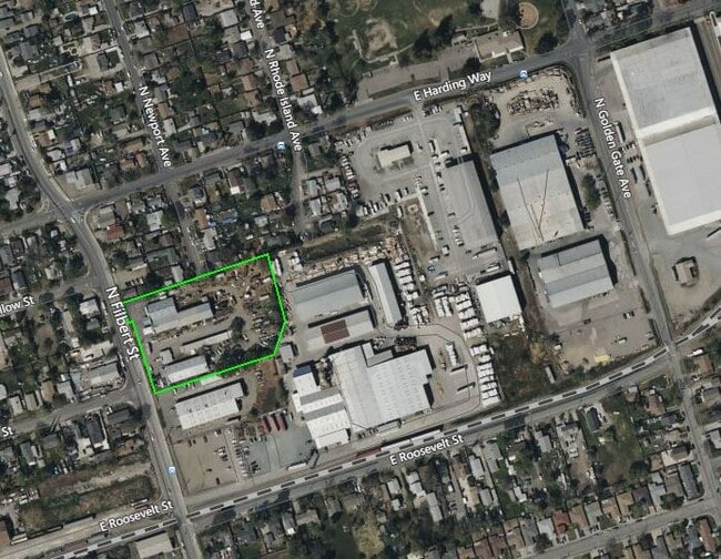
1240 N Filbert St, Stockton, CA 95205


This Property Is For Sale
NEARBY LISTINGS FOR SALE OR LEASE
Property Detail
1240 N Filbert St
Stockton-Lodi, CA
El Ricado
143-100-22
82-FM 143-100-01,02 & 03 PER OWNERS REQUEST
Lightindustrial
San Joaquin
X
California
06077C0460F
3
2025
2.79 AC
2025
NE Stockton
001700
Stockton/Modesto
DEMOGRAPHICS near 1240 N Filbert St
1 Mile
3 Mile
5 Mile
2024 Total Population
15,633
130,852
286,202
2029 Population
16,417
137,874
301,625
Pop Growth 2024-2029
+ 5.02%
+ 5.37%
+ 5.39%
Average Age
34
35
36
2024 Total Households
4,396
39,678
87,530
HH Growth 2024-2029
+ 4.98%
+ 5.54%
+ 5.49%
Median Household Inc
$56,040
$49,207
$59,378
Avg Household Size
3.50
3.10
3.10
2024 Avg HH Vehicles
2.00
2.00
2.00
Median Home Value
$231,435
$314,802
$340,936
Median Year Built
1958
1963
1972
Nearby Places
Map Layers
Map Styles
 Street
 Aerial
- Restaurants
- Banks
- Shops
- Fitness
- Groceries
PUBLIC TRANSPORTATION
COMMUTER RAIL
Stockton (ACE Train - Altamont Commuter Express (ACE), Altamont Corridor Express - Altamont Commuter Express (ACE))
DRIVE
WALK
Distance
Stockton (ACE Train - Altamont Commuter Express (ACE), Altamont Corridor Express - Altamont Commuter Express (ACE))
5 min
2.5 mi
Stockton (San Joaquins - Amtrak)
DRIVE
WALK
Distance
Stockton (San Joaquins - Amtrak)
7 min
3.5 mi
AIRPORT
Stockton Metro
DRIVE
WALK
Distance
Stockton Metro
14 min
7.2 mi
Freight Ports
Port of Stockton
DRIVE
WALK
Distance
Port of Stockton
12 min
6.0 mi
Nearby Properties
Address
Land Use
TOTAL SIZE
Lot Size
Zoning
Address
Land Use
TOTAL SIZE
Lot Size
Zoning
530,700 SF
8.35 AC
Address
Land Use
TOTAL SIZE
Lot Size
Zoning
30,080 SF
82.44 AC
Address
Land Use
TOTAL SIZE
Lot Size
Zoning
152,000 SF
1.31 AC
Address
Land Use
TOTAL SIZE
Lot Size
Zoning
4.78 AC
Address
Land Use
TOTAL SIZE
Lot Size
Zoning
780,371 SF
46.04 AC
IG
Address
Land Use
TOTAL SIZE
Lot Size
Zoning
9,750 SF
136.94 AC
AU20
Address
Land Use
TOTAL SIZE
Lot Size
Zoning
502,000 SF
19.76 AC
Address
Land Use
TOTAL SIZE
Lot Size
Zoning
22.89 AC
Address
Land Use
TOTAL SIZE
Lot Size
Zoning
652,548 SF
35.24 AC
IL
Address
Land Use
TOTAL SIZE
Lot Size
Zoning
121,574 SF
5.49 AC
RHD
Address
Land Use
TOTAL SIZE
Lot Size
Zoning
47.61 AC
Address
Land Use
TOTAL SIZE
Lot Size
Zoning
265,496 SF
12.37 AC
Address
Land Use
TOTAL SIZE
Lot Size
Zoning
219,572 SF
16.53 AC
IL
Address
Land Use
TOTAL SIZE
Lot Size
Zoning
197,876 SF
10.21 AC
Address
Land Use
TOTAL SIZE
Lot Size
Zoning
15,203 SF
3.65 AC
Address
Land Use
TOTAL SIZE
Lot Size
Zoning
8,000 SF
0.67 AC
Address
Land Use
TOTAL SIZE
Lot Size
Zoning
62,588 SF
43.56 AC
IW
Address
Land Use
TOTAL SIZE
Lot Size
Zoning
0.79 AC
Address
Land Use
TOTAL SIZE
Lot Size
Zoning
37,846 SF
2.94 AC
Address
Land Use
TOTAL SIZE
Lot Size
Zoning
14.76 AC
Address
Land Use
TOTAL SIZE
Lot Size
Zoning
2.42 AC
Address
Land Use
TOTAL SIZE
Lot Size
Zoning
2,876 SF
10.54 AC
Address
Land Use
TOTAL SIZE
Lot Size
Zoning
67,195 SF
5.30 AC
Address
Land Use
TOTAL SIZE
Lot Size
Zoning
5,264 SF
9.82 AC
IL
Address
Land Use
TOTAL SIZE
Lot Size
Zoning
178,260 SF
10.75 AC
Address
Land Use
TOTAL SIZE
Lot Size
Zoning
95,838 SF
10.10 AC
Address
Land Use
TOTAL SIZE
Lot Size
Zoning
96,768 SF
6.23 AC
Address
Land Use
TOTAL SIZE
Lot Size
Zoning
129,750 SF
8.63 AC
Address
Land Use
TOTAL SIZE
Lot Size
Zoning
261,860 SF
7.48 AC
IW
Address
Land Use
TOTAL SIZE
Lot Size
Zoning
8 AC
IL
The World's #1 Commercial Real Estate Marketplace
Connect with us
© 2025 CoStar Group
The information above has been obtained from sources believed reliable. While we do not doubt its accuracy we have not verified it and make no guarantee, warranty or representation about it. It is your responsibility to independently confirm its accuracy and completeness. Any projections, opinions, assumptions, or estimates used are for example only and do not represent the current or future performance of the property. The value of this transaction to you depends on tax and other factors which should be evaluated by your tax, financial, and legal advisors. You and your advisors should conduct a careful, independent investigation of the property to determine to your satisfaction the suitability of the property for your needs.