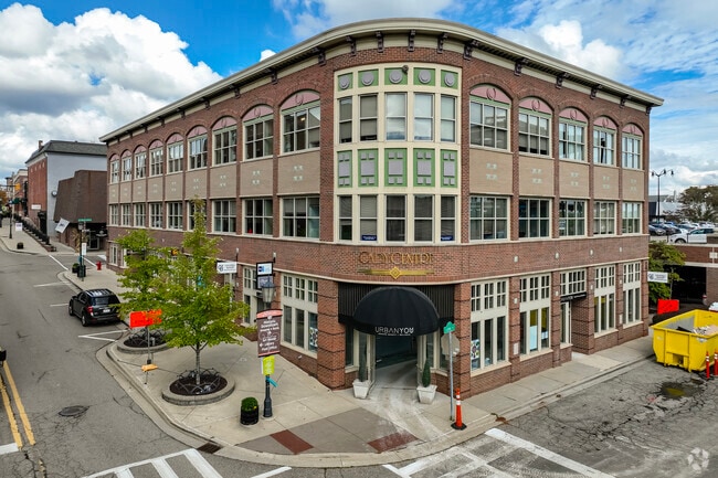
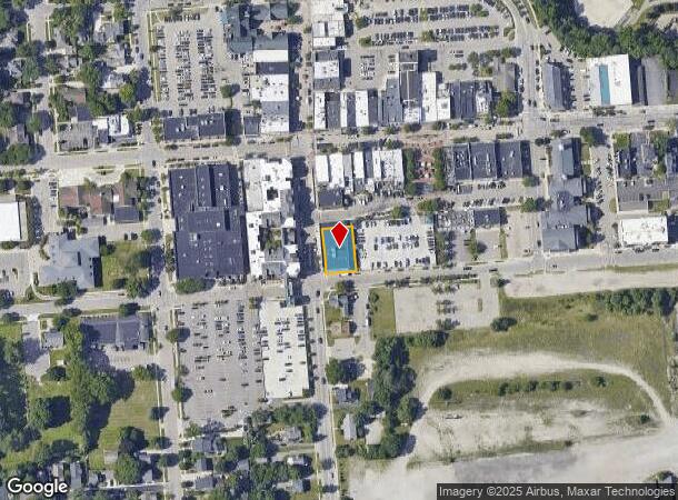
Property Record
125 Cadycentre, Northville, MI 48167

Current Lease Availabilities
NEARBY LISTINGS FOR SALE OR LEASE
Property Detail
125 Cadycentre
Detroit-Warren-Dearborn, MI
Assessors Northville
48-004-02-0044-301
03N44 43B ALL OF LOT 44 AND A PT OF LT 43 DESC AS BEG AT THE SW COR OF LT 43, TH N 4DEG 30M 50S W 16.20 FT, TH N 85DEG 29M 10S E 72.86 FT, TH S 3DEG 59M E 15.84 FT, TH S 85DEG 12M 10S W 72.71 FT TO THE POB; ASSESSORS NORTHVILLE PLAT NO 1 T1SR8E L66 P
Officebuilding
Wayne
X
Michigan
26163C0036E
43-44
2025
0.21 AC
2025
Southern I-275 Corridor
560100
Detroit
24,020 SF
DEMOGRAPHICS near 125 Cadycentre
1 Mile
3 Mile
5 Mile
2024 Total Population
8,741
58,379
143,783
2029 Population
8,502
56,895
140,064
Pop Growth 2024-2029
(2.73%)
(2.54%)
(2.59%)
Average Age
45
43
42
2024 Total Households
4,025
22,884
58,067
HH Growth 2024-2029
(2.73%)
(2.52%)
(2.59%)
Median Household Inc
$102,604
$126,725
$115,007
Avg Household Size
2.20
2.50
2.40
2024 Avg HH Vehicles
2.00
2.00
2.00
Median Home Value
$385,416
$433,374
$385,295
Median Year Built
1973
1985
1982
Nearby Places
Map Layers
Map Styles
 Street
 Aerial
- Restaurants
- Banks
- Shops
- Fitness
- Groceries
PUBLIC TRANSPORTATION
AIRPORT
Detroit Metro Wayne County
DRIVE
WALK
Distance
Detroit Metro Wayne County
31 min
24.1 mi
Windsor International
DRIVE
WALK
Distance
Windsor International
57 min
38.4 mi
Freight Ports
Port of Toledo
DRIVE
WALK
Distance
Port of Toledo
81 min
65.7 mi
Nearby Properties
Address
Land Use
TOTAL SIZE
Lot Size
Zoning
Address
Land Use
TOTAL SIZE
Lot Size
Zoning
57.28 AC
RM-1
Address
Land Use
TOTAL SIZE
Lot Size
Zoning
182,121 SF
10.85 AC
HPUD
Address
Land Use
TOTAL SIZE
Lot Size
Zoning
42.06 AC
RM-1
Address
Land Use
TOTAL SIZE
Lot Size
Zoning
38 AC
RM-1
Address
Land Use
TOTAL SIZE
Lot Size
Zoning
102,878 SF
10.48 AC
CJ
Address
Land Use
TOTAL SIZE
Lot Size
Zoning
289,722 SF
7.34 AC
C-2
Address
Land Use
TOTAL SIZE
Lot Size
Zoning
334,346 SF
55.65 AC
TAR
Address
Land Use
TOTAL SIZE
Lot Size
Zoning
30.32 AC
RM-1
Address
Land Use
TOTAL SIZE
Lot Size
Zoning
5,339 SF
20.10 AC
R-3
Address
Land Use
TOTAL SIZE
Lot Size
Zoning
206,496 SF
12.72 AC
PO
Address
Land Use
TOTAL SIZE
Lot Size
Zoning
80,574 SF
19.95 AC
7MIPUD
Address
Land Use
TOTAL SIZE
Lot Size
Zoning
9,706 SF
40.41 AC
RM-1
Address
Land Use
TOTAL SIZE
Lot Size
Zoning
99,826 SF
ORT
Address
Land Use
TOTAL SIZE
Lot Size
Zoning
129,448 SF
9.37 AC
OSC
Address
Land Use
TOTAL SIZE
Lot Size
Zoning
110,220 SF
0.78 AC
CBD
Address
Land Use
TOTAL SIZE
Lot Size
Zoning
46.60 AC
R-3
Address
Land Use
TOTAL SIZE
Lot Size
Zoning
78,164 SF
5.51 AC
PUD
Address
Land Use
TOTAL SIZE
Lot Size
Zoning
510.78 AC
R-2
Address
Land Use
TOTAL SIZE
Lot Size
Zoning
66,109 SF
35.02 AC
PO
Address
Land Use
TOTAL SIZE
Lot Size
Zoning
976 SF
26.85 AC
RM-1
Address
Land Use
TOTAL SIZE
Lot Size
Zoning
152,414 SF
13.91 AC
RM-1
Address
Land Use
TOTAL SIZE
Lot Size
Zoning
103,075 SF
8.15 AC
PUD
Address
Land Use
TOTAL SIZE
Lot Size
Zoning
16.54 AC
RM-1
Address
Land Use
TOTAL SIZE
Lot Size
Zoning
237,049 SF
27.23 AC
B-3
Address
Land Use
TOTAL SIZE
Lot Size
Zoning
25.57 AC
RM-1
Address
Land Use
TOTAL SIZE
Lot Size
Zoning
19.68 AC
RM-1
Address
Land Use
TOTAL SIZE
Lot Size
Zoning
113,994 SF
6.32 AC
SH
Address
Land Use
TOTAL SIZE
Lot Size
Zoning
135,586 SF
8.08 AC
IND
Address
Land Use
TOTAL SIZE
Lot Size
Zoning
191,759 SF
26.11 AC
ORT
Address
Land Use
TOTAL SIZE
Lot Size
Zoning
58,300 SF
20.64 AC
RM-1
The World's #1 Commercial Real Estate Marketplace
Connect with us
© 2026 CoStar Group
The information above has been obtained from sources believed reliable. While we do not doubt its accuracy we have not verified it and make no guarantee, warranty or representation about it. It is your responsibility to independently confirm its accuracy and completeness. Any projections, opinions, assumptions, or estimates used are for example only and do not represent the current or future performance of the property. The value of this transaction to you depends on tax and other factors which should be evaluated by your tax, financial, and legal advisors. You and your advisors should conduct a careful, independent investigation of the property to determine to your satisfaction the suitability of the property for your needs.