Property Record
125 Hill Rd, Perry, GA 31069
NEARBY LISTINGS FOR SALE OR LEASE
-
-
-
-
No Photo
-
-
-
-
View all Perry listings for sale on LoopNet.com
Property Detail
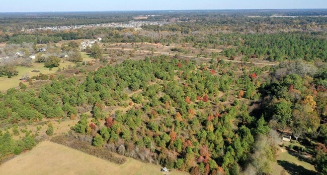
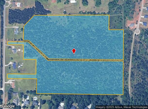
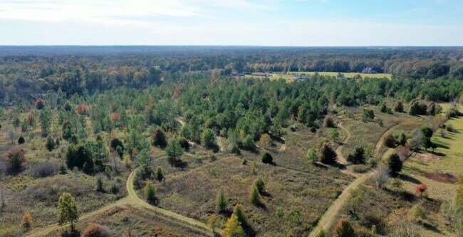
125 Hill Rd
Warner Robins, GA
30.47 ACRES LL 189 13TH LD
0P0480035000
Houston
Residentialacreage
Georgia
X
189
13153C0154E
30.47 AC
2024
Perry/Warner Robins
2024
Other Market Areas
021401
DEMOGRAPHICS near 125 Hill Rd
1 Mile
3 Mile
5 Mile
2024 Total Population
1,445
15,213
28,452
2029 Population
1,589
16,786
31,473
Pop Growth 2024-2029
+ 9.97%
+ 10.34%
+ 10.62%
Average Age
38
38
38
2024 Total Households
497
5,753
10,686
HH Growth 2024-2029
+ 9.66%
+ 10.15%
+ 10.43%
Median Household Inc
$83,606
$66,315
$72,039
Avg Household Size
2.70
2.50
2.50
2024 Avg HH Vehicles
2.00
2.00
2.00
Median Home Value
$187,189
$176,197
$180,034
Median Year Built
2001
1989
1998
Nearby Places
Map Layers
Map Styles
 Street
 Aerial
- Restaurants
- Banks
- Shops
- Fitness
- Groceries
SALE & LEASE HISTORY
LISTING DATE
SALE/LEASE

Feb 06, 2020
For Sale
Nearby Properties
Address
Land Use
TOTAL SIZE
Lot Size
Zoning
Address
Land Use
TOTAL SIZE
Lot Size
Zoning
147,496 SF
66.05 AC
GU
Address
Land Use
TOTAL SIZE
Lot Size
Zoning
262,500 SF
20 AC
GU
Address
Land Use
TOTAL SIZE
Lot Size
Zoning
49,947 SF
4.03 AC
C2
Address
Land Use
TOTAL SIZE
Lot Size
Zoning
78,010 SF
20 AC
C2
Address
Land Use
TOTAL SIZE
Lot Size
Zoning
6,382 SF
24.71 AC
RM-2
Address
Land Use
TOTAL SIZE
Lot Size
Zoning
5,736 SF
16.65 AC
RM-2
Address
Land Use
TOTAL SIZE
Lot Size
Zoning
25,002 SF
15.17 AC
RM-2
Address
Land Use
TOTAL SIZE
Lot Size
Zoning
442.42 AC
M2
Address
Land Use
TOTAL SIZE
Lot Size
Zoning
46,200 SF
12.29 AC
C2
Address
Land Use
TOTAL SIZE
Lot Size
Zoning
19,810 SF
79.64 AC
GU
Address
Land Use
TOTAL SIZE
Lot Size
Zoning
31,248 SF
10.30 AC
RM-2
Address
Land Use
TOTAL SIZE
Lot Size
Zoning
255.39 AC
GU/M1
Address
Land Use
TOTAL SIZE
Lot Size
Zoning
4,820 SF
14.59 AC
RM-2
Address
Land Use
TOTAL SIZE
Lot Size
Zoning
12,000 SF
7.27 AC
RM-2
Address
Land Use
TOTAL SIZE
Lot Size
Zoning
226.03 AC
GU
Address
Land Use
TOTAL SIZE
Lot Size
Zoning
30,050 SF
47.52 AC
GU
Address
Land Use
TOTAL SIZE
Lot Size
Zoning
38,066 SF
11.73 AC
GU
Address
Land Use
TOTAL SIZE
Lot Size
Zoning
44,832 SF
11.95 AC
GU
Address
Land Use
TOTAL SIZE
Lot Size
Zoning
42,908 SF
7.93 AC
C2
Address
Land Use
TOTAL SIZE
Lot Size
Zoning
124.57 AC
M2
Address
Land Use
TOTAL SIZE
Lot Size
Zoning
77,000 SF
11 AC
RAG
Address
Land Use
TOTAL SIZE
Lot Size
Zoning
6,948 SF
10 AC
C2
Address
Land Use
TOTAL SIZE
Lot Size
Zoning
33,970 SF
2.47 AC
C2
Address
Land Use
TOTAL SIZE
Lot Size
Zoning
25,600 SF
10 AC
GU
Address
Land Use
TOTAL SIZE
Lot Size
Zoning
3,200 SF
9.61 AC
RM-2
Address
Land Use
TOTAL SIZE
Lot Size
Zoning
91,869 SF
8.09 AC
C2
Address
Land Use
TOTAL SIZE
Lot Size
Zoning
26,162 SF
14.77 AC
C2
Address
Land Use
TOTAL SIZE
Lot Size
Zoning
2,596 SF
69.21 AC
GU
Address
Land Use
TOTAL SIZE
Lot Size
Zoning
48,828 SF
6.07 AC
C2
Address
Land Use
TOTAL SIZE
Lot Size
Zoning
32,704 SF
2.74 AC
GU
The World's #1 Commercial Real Estate Marketplace
Connect with us
© 2025 CoStar Group
The information above has been obtained from sources believed reliable. While we do not doubt its accuracy we have not verified it and make no guarantee, warranty or representation about it. It is your responsibility to independently confirm its accuracy and completeness. Any projections, opinions, assumptions, or estimates used are for example only and do not represent the current or future performance of the property. The value of this transaction to you depends on tax and other factors which should be evaluated by your tax, financial, and legal advisors. You and your advisors should conduct a careful, independent investigation of the property to determine to your satisfaction the suitability of the property for your needs.