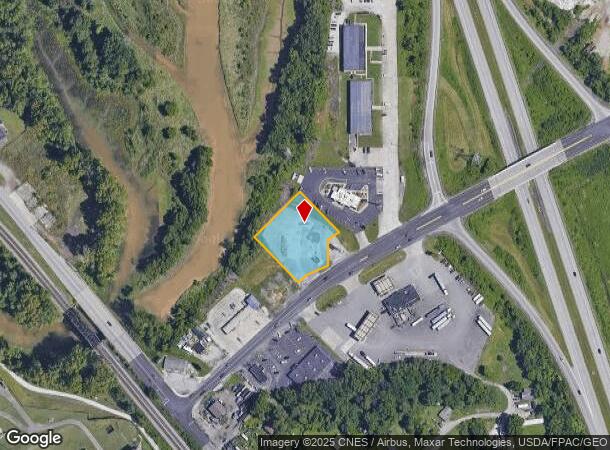
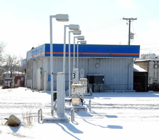
Property Record
125 Marion Pike, Ironton, OH 45638

NEARBY LISTINGS FOR SALE OR LEASE
Property Detail
125 Marion Pike
Huntington-Ashland, WV-KY-OH
Newton Estate
29-048-1300-000
-00-00 10 NEWTON ESTATE NE COR. E PT. 0001.06A
Commercialacreage
Lawrence
AE
Ohio
21019C0057E
10
0
1.06 AC
2024
Lawrence County
050900
Huntington/Ashland
DEMOGRAPHICS near 125 Marion Pike
1 Mile
3 Mile
5 Mile
2024 Total Population
2,406
30,306
61,379
2029 Population
2,324
29,786
60,276
Pop Growth 2024-2029
(3.41%)
(1.72%)
(1.80%)
Average Age
42
42
42
2024 Total Households
976
12,814
25,442
HH Growth 2024-2029
(3.18%)
(1.60%)
(1.72%)
Median Household Inc
$46,375
$44,062
$51,142
Avg Household Size
2.30
2.30
2.30
2024 Avg HH Vehicles
2.00
2.00
2.00
Median Home Value
$107,143
$104,756
$117,414
Median Year Built
1952
1960
1966
Nearby Places
- Restaurants
- Banks
- Shops
- Fitness
- Groceries
PUBLIC TRANSPORTATION
COMMUTER RAIL
Ashland Amtrak Station (Cardinal - Amtrak)
DRIVE
WALK
Distance
Ashland Amtrak Station (Cardinal - Amtrak)
4 min
2.1 mi
AIRPORT
Tri-State/Milton J Ferguson Field
DRIVE
WALK
Distance
Tri-State/Milton J Ferguson Field
25 min
14.0 mi
Freight Ports
Port of Toledo
DRIVE
WALK
Distance
Port of Toledo
331 min
255.8 mi
Nearby Properties
Address
Land Use
TOTAL SIZE
Lot Size
Zoning
Address
Land Use
TOTAL SIZE
Lot Size
Zoning
6.96 AC
Z02
Address
Land Use
TOTAL SIZE
Lot Size
Zoning
36.49 AC
OTHER
Address
Land Use
TOTAL SIZE
Lot Size
Zoning
Address
Land Use
TOTAL SIZE
Lot Size
Zoning
29.92 AC
Z02
Address
Land Use
TOTAL SIZE
Lot Size
Zoning
3,514 SF
21.96 AC
Z02
Address
Land Use
TOTAL SIZE
Lot Size
Zoning
0.99 AC
Z02
Address
Land Use
TOTAL SIZE
Lot Size
Zoning
1.94 AC
Z03
Address
Land Use
TOTAL SIZE
Lot Size
Zoning
16.29 AC
COMMERCIAL
Address
Land Use
TOTAL SIZE
Lot Size
Zoning
Address
Land Use
TOTAL SIZE
Lot Size
Zoning
116,640 SF
0.97 AC
COMMERCIAL
Address
Land Use
TOTAL SIZE
Lot Size
Zoning
11.95 AC
Address
Land Use
TOTAL SIZE
Lot Size
Zoning
12.54 AC
Address
Land Use
TOTAL SIZE
Lot Size
Zoning
4.47 AC
COMMERCIAL
Address
Land Use
TOTAL SIZE
Lot Size
Zoning
28.87 AC
COMMERCIAL
Address
Land Use
TOTAL SIZE
Lot Size
Zoning
0.73 AC
Z02
Address
Land Use
TOTAL SIZE
Lot Size
Zoning
0.38 AC
COMMERCIAL
Address
Land Use
TOTAL SIZE
Lot Size
Zoning
40.94 AC
Address
Land Use
TOTAL SIZE
Lot Size
Zoning
Address
Land Use
TOTAL SIZE
Lot Size
Zoning
1.67 AC
RESIDENTIA
Address
Land Use
TOTAL SIZE
Lot Size
Zoning
1.63 AC
COMMERCIAL
Address
Land Use
TOTAL SIZE
Lot Size
Zoning
19.91 AC
Address
Land Use
TOTAL SIZE
Lot Size
Zoning
1,424 SF
6.46 AC
Address
Land Use
TOTAL SIZE
Lot Size
Zoning
139,148 SF
Address
Land Use
TOTAL SIZE
Lot Size
Zoning
1.95 AC
COMMERCIAL
Address
Land Use
TOTAL SIZE
Lot Size
Zoning
35,014 SF
3.81 AC
Address
Land Use
TOTAL SIZE
Lot Size
Zoning
4.30 AC
COMMERCIAL
Address
Land Use
TOTAL SIZE
Lot Size
Zoning
30,250 SF
8.29 AC
Address
Land Use
TOTAL SIZE
Lot Size
Zoning
75,820 SF
1.71 AC
Address
Land Use
TOTAL SIZE
Lot Size
Zoning
Address
Land Use
TOTAL SIZE
Lot Size
Zoning
0.21 AC
Z02
The World's #1 Commercial Real Estate Marketplace
Connect with us
© 2025 CoStar Group
The information above has been obtained from sources believed reliable. While we do not doubt its accuracy we have not verified it and make no guarantee, warranty or representation about it. It is your responsibility to independently confirm its accuracy and completeness. Any projections, opinions, assumptions, or estimates used are for example only and do not represent the current or future performance of the property. The value of this transaction to you depends on tax and other factors which should be evaluated by your tax, financial, and legal advisors. You and your advisors should conduct a careful, independent investigation of the property to determine to your satisfaction the suitability of the property for your needs.