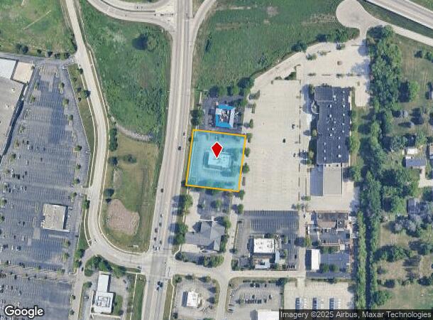
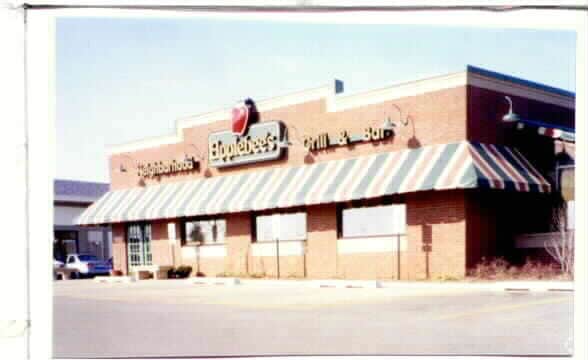
Property Record
125 S Randall Rd, Elgin, IL 60123


NEARBY LISTINGS FOR SALE OR LEASE
Property Detail
125 S Randall Rd
Chicago-Naperville-Elgin, IL-IN
Randall Lake Crossing
06-16-352-009
NONE LOT 17 EXCEPT THE SOUTHERLY 30 FT & LOT 18 EXCEPT THE NORTHERLY 5.33 FT OF RANDALL LAKE CROSSING
Commercialnec
Kane
X
Illinois
17089C0164H
17,18
2024
1.14 AC
2024
Far Northwest
851908
Chicago
4,995 SF
DEMOGRAPHICS near 125 S Randall Rd
1 Mile
3 Mile
5 Mile
2024 Total Population
5,490
78,691
155,744
2029 Population
5,363
78,211
154,280
Pop Growth 2024-2029
(2.31%)
(0.61%)
(0.94%)
Average Age
43
39
39
2024 Total Households
1,966
27,701
52,922
HH Growth 2024-2029
(2.39%)
(0.66%)
(1.01%)
Median Household Inc
$84,751
$93,513
$93,007
Avg Household Size
2.70
2.80
2.90
2024 Avg HH Vehicles
2.00
2.00
2.00
Median Home Value
$272,314
$260,430
$259,210
Median Year Built
1980
1985
1983
Nearby Places
Map Layers
Map Styles
 Street
 Aerial
- Restaurants
- Banks
- Shops
- Fitness
- Groceries
PUBLIC TRANSPORTATION
COMMUTER RAIL
Big Timber Road Station (Milwaukee District West Line - Northeast Illinois Regional Commuter Railroad (Metra))
DRIVE
WALK
Distance
Big Timber Road Station (Milwaukee District West Line - Northeast Illinois Regional Commuter Railroad (Metra))
7 min
3.4 mi
National Street Station (Milwaukee District West Line - Northeast Illinois Regional Commuter Railroad (Metra))
DRIVE
WALK
Distance
National Street Station (Milwaukee District West Line - Northeast Illinois Regional Commuter Railroad (Metra))
9 min
4.2 mi
AIRPORT
Chicago O'Hare International
DRIVE
WALK
Distance
Chicago O'Hare International
58 min
33.4 mi
Chicago Midway International
DRIVE
WALK
Distance
Chicago Midway International
69 min
40.6 mi
Nearby Properties
Address
Land Use
TOTAL SIZE
Lot Size
Zoning
Address
Land Use
TOTAL SIZE
Lot Size
Zoning
27.33 AC
Address
Land Use
TOTAL SIZE
Lot Size
Zoning
Address
Land Use
TOTAL SIZE
Lot Size
Zoning
99,800 SF
0.53 AC
Address
Land Use
TOTAL SIZE
Lot Size
Zoning
238,115 SF
21.61 AC
Address
Land Use
TOTAL SIZE
Lot Size
Zoning
35,808 SF
11.40 AC
Address
Land Use
TOTAL SIZE
Lot Size
Zoning
8,012 SF
6.56 AC
Address
Land Use
TOTAL SIZE
Lot Size
Zoning
217,848 SF
9.81 AC
Address
Land Use
TOTAL SIZE
Lot Size
Zoning
76,884 SF
2.87 AC
Address
Land Use
TOTAL SIZE
Lot Size
Zoning
11.07 AC
Address
Land Use
TOTAL SIZE
Lot Size
Zoning
93,341 SF
3.67 AC
Address
Land Use
TOTAL SIZE
Lot Size
Zoning
186,692 SF
19.48 AC
Address
Land Use
TOTAL SIZE
Lot Size
Zoning
30,000 SF
9.96 AC
Address
Land Use
TOTAL SIZE
Lot Size
Zoning
0.20 AC
Address
Land Use
TOTAL SIZE
Lot Size
Zoning
9.11 AC
Address
Land Use
TOTAL SIZE
Lot Size
Zoning
8.98 AC
Address
Land Use
TOTAL SIZE
Lot Size
Zoning
10.03 AC
Address
Land Use
TOTAL SIZE
Lot Size
Zoning
142,044 SF
14.98 AC
Address
Land Use
TOTAL SIZE
Lot Size
Zoning
Address
Land Use
TOTAL SIZE
Lot Size
Zoning
179,857 SF
4.60 AC
Address
Land Use
TOTAL SIZE
Lot Size
Zoning
146,694 SF
10.25 AC
Address
Land Use
TOTAL SIZE
Lot Size
Zoning
5.44 AC
Address
Land Use
TOTAL SIZE
Lot Size
Zoning
137,500 SF
12.51 AC
Address
Land Use
TOTAL SIZE
Lot Size
Zoning
103,536 SF
17.71 AC
Address
Land Use
TOTAL SIZE
Lot Size
Zoning
Address
Land Use
TOTAL SIZE
Lot Size
Zoning
134,434 SF
8.83 AC
Address
Land Use
TOTAL SIZE
Lot Size
Zoning
7.51 AC
Address
Land Use
TOTAL SIZE
Lot Size
Zoning
61,720 SF
10.02 AC
Address
Land Use
TOTAL SIZE
Lot Size
Zoning
14.40 AC
Address
Land Use
TOTAL SIZE
Lot Size
Zoning
78,985 SF
3 AC
The World's #1 Commercial Real Estate Marketplace
Connect with us
© 2026 CoStar Group
The information above has been obtained from sources believed reliable. While we do not doubt its accuracy we have not verified it and make no guarantee, warranty or representation about it. It is your responsibility to independently confirm its accuracy and completeness. Any projections, opinions, assumptions, or estimates used are for example only and do not represent the current or future performance of the property. The value of this transaction to you depends on tax and other factors which should be evaluated by your tax, financial, and legal advisors. You and your advisors should conduct a careful, independent investigation of the property to determine to your satisfaction the suitability of the property for your needs.