Property Record
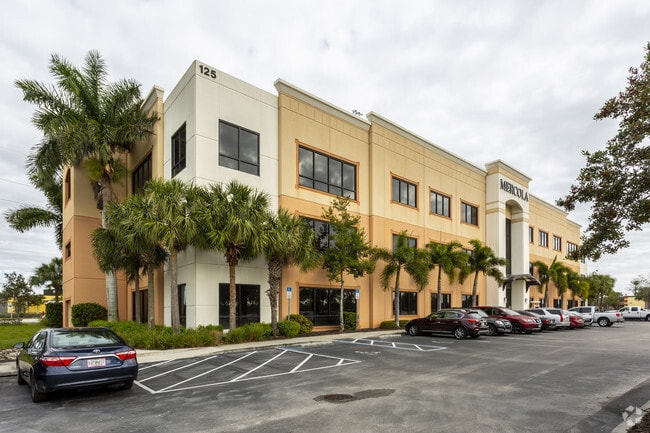
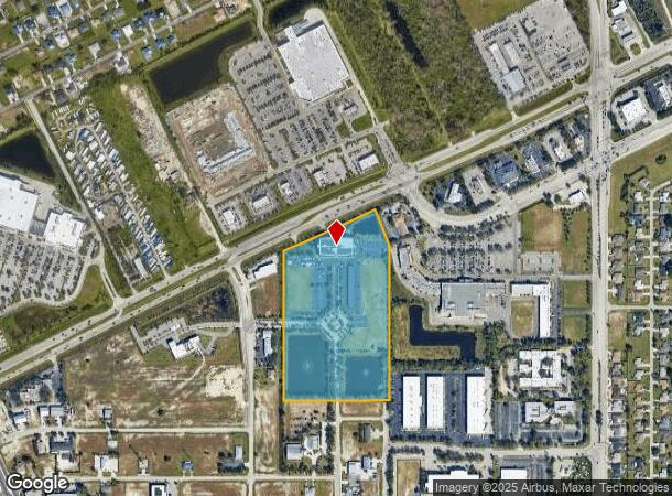
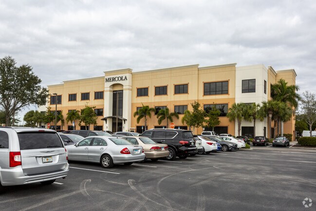
125 Sw 3Rd Pl, Cape Coral, FL 33991
NEARBY LISTINGS FOR SALE OR LEASE
Property Detail
125 Sw 3Rd Pl
14-44-23-C2-00004.001A
Pine Island Rd Corridor Bb
Officebuilding
PARL LOC IN NE 1/4 DESC IN OR 1881/297 + OR 3202/2304 AS DESC IN INST# 2009000042074
X
Lee
12071C0263G
Florida
2024
12.39 AC
2025
Cape Coral
010306
Southwest Florida
68,409 SF
Cape Coral-Fort Myers, FL
DEMOGRAPHICS near 125 Sw 3Rd Pl
1 Mile
3 Mile
5 Mile
2024 Total Population
6,634
69,783
168,102
2029 Population
7,947
82,631
199,465
Pop Growth 2024-2029
+ 19.79%
+ 18.41%
+ 18.66%
Average Age
40
40
42
2024 Total Households
2,297
24,817
62,309
HH Growth 2024-2029
+ 19.16%
+ 17.79%
+ 18.10%
Median Household Inc
$60,463
$65,675
$67,955
Avg Household Size
2.80
2.70
2.60
2024 Avg HH Vehicles
2.00
2.00
2.00
Median Home Value
$235,832
$258,239
$271,032
Median Year Built
2003
2000
2000
Nearby Places
Map Layers
Map Styles
 Street
 Aerial
- Restaurants
- Banks
- Shops
- Fitness
- Groceries
PUBLIC TRANSPORTATION
AIRPORT
Southwest Florida International
DRIVE
WALK
Distance
Southwest Florida International
38 min
22.8 mi
Punta Gorda
DRIVE
WALK
Distance
Punta Gorda
37 min
24.8 mi
Freight Ports
Port Manatee
DRIVE
WALK
Distance
Port Manatee
117 min
96.5 mi
SALE & LEASE HISTORY
LISTING DATE
SALE/LEASE

Sep 25, 2016
For Lease
Nearby Properties
Address
Land Use
TOTAL SIZE
Lot Size
Zoning
Address
Land Use
TOTAL SIZE
Lot Size
Zoning
634,872 SF
43.30 AC
C1-D
Address
Land Use
TOTAL SIZE
Lot Size
Zoning
476,419 SF
36.49 AC
C1
Address
Land Use
TOTAL SIZE
Lot Size
Zoning
507,243 SF
115.38 AC
A
Address
Land Use
TOTAL SIZE
Lot Size
Zoning
25.99 AC
RML
Address
Land Use
TOTAL SIZE
Lot Size
Zoning
231,454 SF
14.53 AC
CC
Address
Land Use
TOTAL SIZE
Lot Size
Zoning
339,525 SF
38.30 AC
R1BD
Address
Land Use
TOTAL SIZE
Lot Size
Zoning
7.82 AC
CORR
Address
Land Use
TOTAL SIZE
Lot Size
Zoning
282,066 SF
39.45 AC
INS
Address
Land Use
TOTAL SIZE
Lot Size
Zoning
61,844 SF
7.31 AC
CC
Address
Land Use
TOTAL SIZE
Lot Size
Zoning
101,204 SF
12.34 AC
P1-D
Address
Land Use
TOTAL SIZE
Lot Size
Zoning
27.77 AC
RML
Address
Land Use
TOTAL SIZE
Lot Size
Zoning
101,999 SF
7.17 AC
P-1
Address
Land Use
TOTAL SIZE
Lot Size
Zoning
83,035 SF
19.01 AC
CORR
Address
Land Use
TOTAL SIZE
Lot Size
Zoning
153,651 SF
17.17 AC
R1-B
Address
Land Use
TOTAL SIZE
Lot Size
Zoning
147,599 SF
5.72 AC
RML
Address
Land Use
TOTAL SIZE
Lot Size
Zoning
142,379 SF
3.27 AC
Address
Land Use
TOTAL SIZE
Lot Size
Zoning
62,119 SF
6.50 AC
CORR
Address
Land Use
TOTAL SIZE
Lot Size
Zoning
101,110 SF
8.67 AC
VILL
Address
Land Use
TOTAL SIZE
Lot Size
Zoning
78,298 SF
12.73 AC
CORR
Address
Land Use
TOTAL SIZE
Lot Size
Zoning
102,818 SF
8.60 AC
CORR
Address
Land Use
TOTAL SIZE
Lot Size
Zoning
58,339 SF
3.55 AC
VILL
Address
Land Use
TOTAL SIZE
Lot Size
Zoning
19,218 SF
3.79 AC
CC
Address
Land Use
TOTAL SIZE
Lot Size
Zoning
79,062 SF
5.15 AC
CORR
Address
Land Use
TOTAL SIZE
Lot Size
Zoning
78,988 SF
2.89 AC
C1-D
Address
Land Use
TOTAL SIZE
Lot Size
Zoning
84,145 SF
8.11 AC
C-1
Address
Land Use
TOTAL SIZE
Lot Size
Zoning
58,318 SF
4.99 AC
C
Address
Land Use
TOTAL SIZE
Lot Size
Zoning
100,325 SF
4.86 AC
C-1
Address
Land Use
TOTAL SIZE
Lot Size
Zoning
36,649 SF
2.82 AC
C-1
Address
Land Use
TOTAL SIZE
Lot Size
Zoning
56,092 SF
4.52 AC
CORR
Address
Land Use
TOTAL SIZE
Lot Size
Zoning
201,687 SF
11.80 AC
C-1
The World's #1 Commercial Real Estate Marketplace
Connect with us
© 2025 CoStar Group
The information above has been obtained from sources believed reliable. While we do not doubt its accuracy we have not verified it and make no guarantee, warranty or representation about it. It is your responsibility to independently confirm its accuracy and completeness. Any projections, opinions, assumptions, or estimates used are for example only and do not represent the current or future performance of the property. The value of this transaction to you depends on tax and other factors which should be evaluated by your tax, financial, and legal advisors. You and your advisors should conduct a careful, independent investigation of the property to determine to your satisfaction the suitability of the property for your needs.