Property Record
125 Willie Paulk Pkwy, Dublin, GA 31021
NEARBY LISTINGS FOR SALE OR LEASE
Property Detail
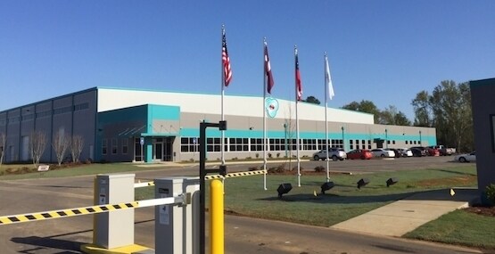
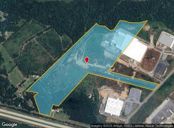
125 Willie Paulk Pkwy
101-012-A
City-County Joint-Owned
Lightindustrial
LL 34 & 51 LD 1 / VAILMERA GLASS
X
Laurens
13175C0188C
Georgia
2024
53.17 AC
2024
Georgia South Area
950500
Other Market Areas
372,555 SF
Dublin, GA
DEMOGRAPHICS near 125 Willie Paulk Pkwy
1 Mile
3 Mile
5 Mile
2024 Total Population
482
3,770
18,815
2029 Population
481
3,756
18,773
Pop Growth 2024-2029
(0.21%)
(0.37%)
(0.22%)
Average Age
43
43
41
2024 Total Households
183
1,440
7,526
HH Growth 2024-2029
(0.55%)
(0.35%)
(0.23%)
Median Household Inc
$28,905
$33,559
$38,772
Avg Household Size
2.50
2.50
2.40
2024 Avg HH Vehicles
2.00
2.00
2.00
Median Home Value
$141,250
$145,423
$154,424
Median Year Built
1988
1986
1980
Nearby Places
Map Layers
Map Styles
 Street
 Aerial
- Restaurants
- Banks
- Shops
- Fitness
- Groceries
Nearby Properties
Address
Land Use
TOTAL SIZE
Lot Size
Zoning
Address
Land Use
TOTAL SIZE
Lot Size
Zoning
217,773 SF
48.62 AC
RESIDENTIA
Address
Land Use
TOTAL SIZE
Lot Size
Zoning
448 SF
95 AC
COMMERCIAL
Address
Land Use
TOTAL SIZE
Lot Size
Zoning
598,082 SF
133.35 AC
INDUSTRIAL
Address
Land Use
TOTAL SIZE
Lot Size
Zoning
484,158 SF
116.80 AC
INDUSTRIAL
Address
Land Use
TOTAL SIZE
Lot Size
Zoning
269,114 SF
43.42 AC
INDUSTRIAL
Address
Land Use
TOTAL SIZE
Lot Size
Zoning
28,160 SF
28.64 AC
INDUSTRIAL
Address
Land Use
TOTAL SIZE
Lot Size
Zoning
47,421 SF
1.57 AC
COMMERCIAL
Address
Land Use
TOTAL SIZE
Lot Size
Zoning
173,468 SF
18.75 AC
RESIDENTIA
Address
Land Use
TOTAL SIZE
Lot Size
Zoning
45,036 SF
2.10 AC
UNZONED SU
Address
Land Use
TOTAL SIZE
Lot Size
Zoning
38,079 SF
1.20 AC
COMMERCIAL
Address
Land Use
TOTAL SIZE
Lot Size
Zoning
12,048 SF
40 AC
UNZONED RU
Address
Land Use
TOTAL SIZE
Lot Size
Zoning
11,088 SF
4.49 AC
UNZONED RU
Address
Land Use
TOTAL SIZE
Lot Size
Zoning
78,501 SF
18.52 AC
UNZONED SU
Address
Land Use
TOTAL SIZE
Lot Size
Zoning
80,000 SF
25.50 AC
INDUSTRIAL
Address
Land Use
TOTAL SIZE
Lot Size
Zoning
40,944 SF
4.60 AC
COMMERCIAL
Address
Land Use
TOTAL SIZE
Lot Size
Zoning
60,000 SF
22.44 AC
COMMERCIAL
Address
Land Use
TOTAL SIZE
Lot Size
Zoning
37,136 SF
4.92 AC
COMMERCIAL
Address
Land Use
TOTAL SIZE
Lot Size
Zoning
70,680 SF
22.72 AC
RESIDENTIA
Address
Land Use
TOTAL SIZE
Lot Size
Zoning
35,120 SF
10.06 AC
UNZONED RU
Address
Land Use
TOTAL SIZE
Lot Size
Zoning
73,260 SF
7.50 AC
INDUSTRIAL
Address
Land Use
TOTAL SIZE
Lot Size
Zoning
19,880 SF
8.65 AC
COMMERCIAL
Address
Land Use
TOTAL SIZE
Lot Size
Zoning
87,479 SF
62.92 AC
UNZONED SU
Address
Land Use
TOTAL SIZE
Lot Size
Zoning
29,058 SF
9.92 AC
COMMERCIAL
Address
Land Use
TOTAL SIZE
Lot Size
Zoning
18,666 SF
2.24 AC
COMMERCIAL
Address
Land Use
TOTAL SIZE
Lot Size
Zoning
19,512 SF
RESIDENTIA
Address
Land Use
TOTAL SIZE
Lot Size
Zoning
19,924 SF
40 AC
UNZONED RU
Address
Land Use
TOTAL SIZE
Lot Size
Zoning
8,426 SF
1.88 AC
COMMERCIAL
Address
Land Use
TOTAL SIZE
Lot Size
Zoning
14,037 SF
1.01 AC
COMMERCIAL
Address
Land Use
TOTAL SIZE
Lot Size
Zoning
11,510 SF
0.91 AC
COMMERCIAL
The World's #1 Commercial Real Estate Marketplace
Connect with us
© 2025 CoStar Group
The information above has been obtained from sources believed reliable. While we do not doubt its accuracy we have not verified it and make no guarantee, warranty or representation about it. It is your responsibility to independently confirm its accuracy and completeness. Any projections, opinions, assumptions, or estimates used are for example only and do not represent the current or future performance of the property. The value of this transaction to you depends on tax and other factors which should be evaluated by your tax, financial, and legal advisors. You and your advisors should conduct a careful, independent investigation of the property to determine to your satisfaction the suitability of the property for your needs.