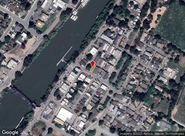
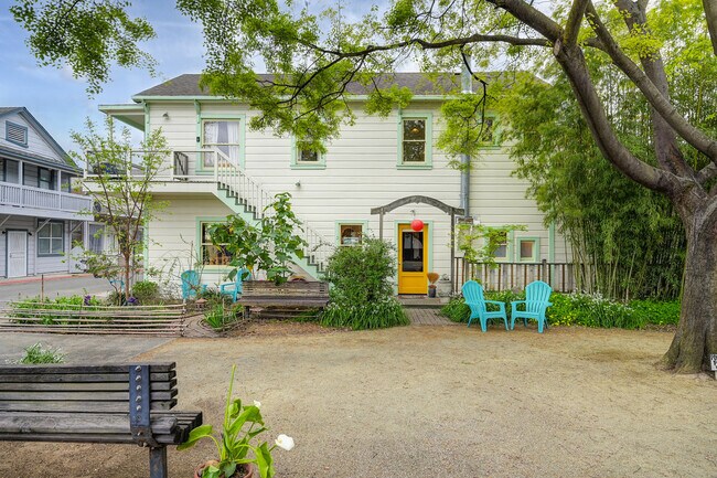
Property Record
1250 B St, Walnut Grove, CA 95690

NEARBY LISTINGS FOR SALE OR LEASE
Property Detail
1250 B St
Sacramento-Roseville-Folsom, CA
Walnut Grove Estates 01
146-0370-035
PORTION LOT26
Storebuilding
Sacramento
X
California
06067C0560H
26
2024
0.46 AC
2025
Elk Grove/Laguna
009900
Sacramento
2,172 SF
DEMOGRAPHICS near 1250 B St
1 Mile
3 Mile
5 Mile
2024 Total Population
1,130
1,770
2,344
2029 Population
1,001
1,594
2,127
Pop Growth 2024-2029
(11.42%)
(9.94%)
(9.26%)
Average Age
42
42
42
2024 Total Households
418
651
838
HH Growth 2024-2029
(11.72%)
(10.29%)
(9.67%)
Median Household Inc
$64,904
$64,408
$63,697
Avg Household Size
2.60
2.60
2.70
2024 Avg HH Vehicles
2.00
2.00
2.00
Median Home Value
$708,092
$684,108
$671,428
Median Year Built
1957
1965
1965
Nearby Places
Map Layers
Map Styles
 Street
 Aerial
- Restaurants
- Banks
- Shops
- Fitness
- Groceries
PUBLIC TRANSPORTATION
AIRPORT
Stockton Metro
DRIVE
WALK
Distance
Stockton Metro
46 min
33.6 mi
Sacramento International
DRIVE
WALK
Distance
Sacramento International
52 min
38.7 mi
Freight Ports
Port of Stockton
DRIVE
WALK
Distance
Port of Stockton
36 min
26.3 mi
SALE & LEASE HISTORY
LISTING DATE
SALE/LEASE

Jun 21, 2024
For Sale
Nearby Properties
Address
Land Use
TOTAL SIZE
Lot Size
Zoning
Address
Land Use
TOTAL SIZE
Lot Size
Zoning
9.07 AC
AG40
Address
Land Use
TOTAL SIZE
Lot Size
Zoning
1,687 SF
658.77 AC
AG40
Address
Land Use
TOTAL SIZE
Lot Size
Zoning
6,798 SF
40 AC
AG-80
Address
Land Use
TOTAL SIZE
Lot Size
Zoning
3,024 SF
159.63 AC
AG-80
Address
Land Use
TOTAL SIZE
Lot Size
Zoning
2,492 SF
214.26 AC
DW-S AG-80
Address
Land Use
TOTAL SIZE
Lot Size
Zoning
205.29 AC
AG40
Address
Land Use
TOTAL SIZE
Lot Size
Zoning
416 AC
AG40
Address
Land Use
TOTAL SIZE
Lot Size
Zoning
56,352 SF
9.66 AC
M-2 AG-80
Address
Land Use
TOTAL SIZE
Lot Size
Zoning
2,700 SF
91.93 AC
AG-20
Address
Land Use
TOTAL SIZE
Lot Size
Zoning
768.22 AC
AG-80
Address
Land Use
TOTAL SIZE
Lot Size
Zoning
720.47 AC
AG-80
Address
Land Use
TOTAL SIZE
Lot Size
Zoning
4,212 SF
127.77 AC
O AG-80
Address
Land Use
TOTAL SIZE
Lot Size
Zoning
4,136 SF
24.32 AC
AG-20
Address
Land Use
TOTAL SIZE
Lot Size
Zoning
936 SF
120.76 AC
AG-80
Address
Land Use
TOTAL SIZE
Lot Size
Zoning
4.52 AC
M-2
Address
Land Use
TOTAL SIZE
Lot Size
Zoning
121.84 AC
AG-80
Address
Land Use
TOTAL SIZE
Lot Size
Zoning
1,548 SF
39.45 AC
AG-20
Address
Land Use
TOTAL SIZE
Lot Size
Zoning
2,939 SF
90 AC
AG-80
Address
Land Use
TOTAL SIZE
Lot Size
Zoning
1,131 SF
82.97 AC
AG40
Address
Land Use
TOTAL SIZE
Lot Size
Zoning
512 SF
4.03 AC
AG40
Address
Land Use
TOTAL SIZE
Lot Size
Zoning
40 AC
AG-40 LC
Address
Land Use
TOTAL SIZE
Lot Size
Zoning
7,950 SF
35 AC
AG-20
Address
Land Use
TOTAL SIZE
Lot Size
Zoning
2,918 SF
100 AC
AG-80
Address
Land Use
TOTAL SIZE
Lot Size
Zoning
190.50 AC
AG-80 O
Address
Land Use
TOTAL SIZE
Lot Size
Zoning
29,280 SF
5.10 AC
M-2 AG-20
Address
Land Use
TOTAL SIZE
Lot Size
Zoning
5,854 SF
295.09 AC
AG-80
Address
Land Use
TOTAL SIZE
Lot Size
Zoning
89.43 AC
AG-80
Address
Land Use
TOTAL SIZE
Lot Size
Zoning
100.15 AC
AG-80
Address
Land Use
TOTAL SIZE
Lot Size
Zoning
682 SF
89.03 AC
AG40
Address
Land Use
TOTAL SIZE
Lot Size
Zoning
2,212 SF
99.34 AC
AG-80
The World's #1 Commercial Real Estate Marketplace
Connect with us
© 2026 CoStar Group
The information above has been obtained from sources believed reliable. While we do not doubt its accuracy we have not verified it and make no guarantee, warranty or representation about it. It is your responsibility to independently confirm its accuracy and completeness. Any projections, opinions, assumptions, or estimates used are for example only and do not represent the current or future performance of the property. The value of this transaction to you depends on tax and other factors which should be evaluated by your tax, financial, and legal advisors. You and your advisors should conduct a careful, independent investigation of the property to determine to your satisfaction the suitability of the property for your needs.