Property Record
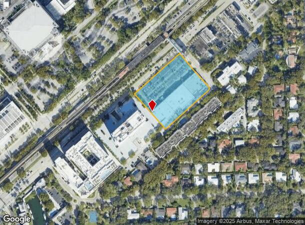
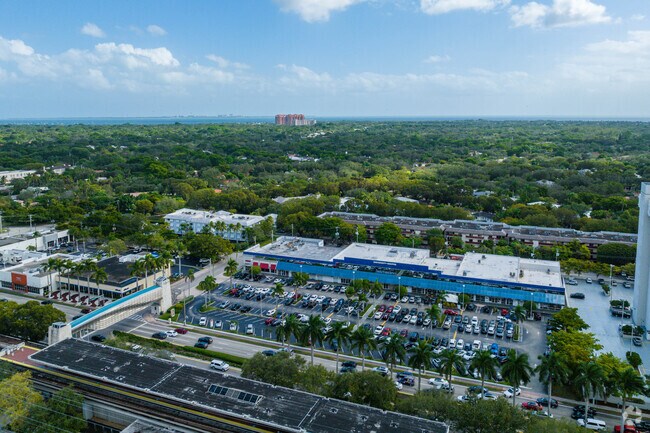
1250 S Dixie Hwy, Coral Gables, FL 33146


NEARBY LISTINGS FOR SALE OR LEASE
Property Detail
1250 S Dixie Hwy
Miami-Miami Beach-Kendall, FL
Coral Gables Riviera
03-4130-004-0010
30 54 41 3.18 AC REPLAT OF PART OF CORAL GABLES RIVIERA SEC PT 8 PB 46-100 THAT PT OF TR A THAT LIES NELY OF FOLLOWING DESC/L COMM AT NELY X OF MIAMI HOMESTEAD HWY & HARDEE RD NELY760FT TO POB SELY325FT ON NW/L OF MADRUGA AVE & LOTS 27 TO 31 INC BLK
Regionalshoppingcenterormallwithanchorstore
Miami/Dade
X
Florida
12086C0459L
27
2024
3.18 AC
2025
Coral Gables
007503
South Florida
64,549 SF
DEMOGRAPHICS near 1250 S Dixie Hwy
1 Mile
3 Mile
5 Mile
2024 Total Population
14,583
119,748
337,015
2029 Population
14,444
118,433
328,381
Pop Growth 2024-2029
(0.95%)
(1.10%)
(2.56%)
Average Age
38
42
43
2024 Total Households
4,520
48,501
129,978
HH Growth 2024-2029
(1.26%)
(1.08%)
(2.69%)
Median Household Inc
$100,882
$89,619
$68,622
Avg Household Size
2.60
2.30
2.50
2024 Avg HH Vehicles
2.00
2.00
2.00
Median Home Value
$903,659
$717,102
$505,015
Median Year Built
1961
1973
1968
Nearby Places
Map Layers
Map Styles
 Street
 Aerial
- Restaurants
- Banks
- Shops
- Fitness
- Groceries
PUBLIC TRANSPORTATION
COMMUTER RAIL
University (Metrorail Green Line - Miami-Dade Transit (Metrorail/Metromover))
DRIVE
WALK
Distance
University (Metrorail Green Line - Miami-Dade Transit (Metrorail/Metromover))
1 min
5 min
0.2 mi
South Miami (Metrorail Green Line - Miami-Dade Transit (Metrorail/Metromover))
DRIVE
WALK
Distance
South Miami (Metrorail Green Line - Miami-Dade Transit (Metrorail/Metromover))
2 min
19 min
1.0 mi
AIRPORT
Miami International
DRIVE
WALK
Distance
Miami International
23 min
11.8 mi
Fort Lauderdale/Hollywood International
DRIVE
WALK
Distance
Fort Lauderdale/Hollywood International
44 min
30.0 mi
Freight Ports
Port of Miami
DRIVE
WALK
Distance
Port of Miami
20 min
9.8 mi
SALE & LEASE HISTORY
LISTING DATE
SALE/LEASE

Sep 20, 2018
For Lease
Apr 28, 2025
For Sale
Nearby Properties
Address
Land Use
TOTAL SIZE
Lot Size
Zoning
Address
Land Use
TOTAL SIZE
Lot Size
Zoning
2,238,641 SF
39 AC
6114
Address
Land Use
TOTAL SIZE
Lot Size
Zoning
870,720 SF
1.90 AC
4800
Address
Land Use
TOTAL SIZE
Lot Size
Zoning
883,561 SF
5.63 AC
8200
Address
Land Use
TOTAL SIZE
Lot Size
Zoning
1,647,481 SF
23.04 AC
5000
Address
Land Use
TOTAL SIZE
Lot Size
Zoning
877,136 SF
2.96 AC
6112
Address
Land Use
TOTAL SIZE
Lot Size
Zoning
715,755 SF
2.66 AC
5005
Address
Land Use
TOTAL SIZE
Lot Size
Zoning
973,728 SF
76.18 AC
8200
Address
Land Use
TOTAL SIZE
Lot Size
Zoning
764,501 SF
1.81 AC
6114
Address
Land Use
TOTAL SIZE
Lot Size
Zoning
644,929 SF
1.10 AC
6114
Address
Land Use
TOTAL SIZE
Lot Size
Zoning
759,863 SF
7.02 AC
6506
Address
Land Use
TOTAL SIZE
Lot Size
Zoning
345,178 SF
6.73 AC
5005
Address
Land Use
TOTAL SIZE
Lot Size
Zoning
1,168,390 SF
0.04 AC
7100
Address
Land Use
TOTAL SIZE
Lot Size
Zoning
423,104 SF
2.58 AC
6200
Address
Land Use
TOTAL SIZE
Lot Size
Zoning
408,292 SF
0.88 AC
6110
Address
Land Use
TOTAL SIZE
Lot Size
Zoning
247,488 SF
4.25 AC
5005
Address
Land Use
TOTAL SIZE
Lot Size
Zoning
275,755 SF
6.73 AC
5005
Address
Land Use
TOTAL SIZE
Lot Size
Zoning
688,104 SF
3.16 AC
6101
Address
Land Use
TOTAL SIZE
Lot Size
Zoning
500,332 SF
3.46 AC
6000
Address
Land Use
TOTAL SIZE
Lot Size
Zoning
532,779 SF
0000
Address
Land Use
TOTAL SIZE
Lot Size
Zoning
365,003 SF
15.05 AC
8200
Address
Land Use
TOTAL SIZE
Lot Size
Zoning
299,785 SF
0.55 AC
6110
Address
Land Use
TOTAL SIZE
Lot Size
Zoning
431,941 SF
2.06 AC
6110
Address
Land Use
TOTAL SIZE
Lot Size
Zoning
407,265 SF
1.59 AC
6100
Address
Land Use
TOTAL SIZE
Lot Size
Zoning
518,244 SF
1.06 AC
5005
Address
Land Use
TOTAL SIZE
Lot Size
Zoning
535,679 SF
2.73 AC
6000
Address
Land Use
TOTAL SIZE
Lot Size
Zoning
668,569 SF
2.33 AC
5004
Address
Land Use
TOTAL SIZE
Lot Size
Zoning
449,572 SF
1.74 AC
6110
Address
Land Use
TOTAL SIZE
Lot Size
Zoning
540,267 SF
1.74 AC
5005
Address
Land Use
TOTAL SIZE
Lot Size
Zoning
14.30 AC
0700
Address
Land Use
TOTAL SIZE
Lot Size
Zoning
859,337 SF
0.13 AC
7100
The World's #1 Commercial Real Estate Marketplace
Connect with us
© 2025 CoStar Group
The information above has been obtained from sources believed reliable. While we do not doubt its accuracy we have not verified it and make no guarantee, warranty or representation about it. It is your responsibility to independently confirm its accuracy and completeness. Any projections, opinions, assumptions, or estimates used are for example only and do not represent the current or future performance of the property. The value of this transaction to you depends on tax and other factors which should be evaluated by your tax, financial, and legal advisors. You and your advisors should conduct a careful, independent investigation of the property to determine to your satisfaction the suitability of the property for your needs.