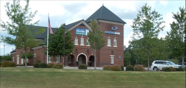
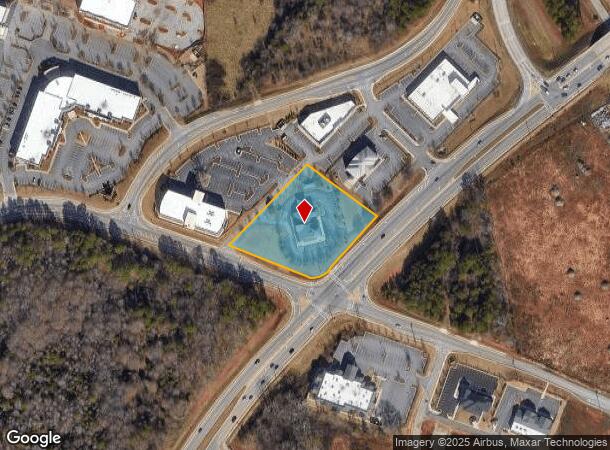
Property Record
1252 Virgil Langford Rd, Watkinsville, GA 30677
Current Lease Availabilities
NEARBY LISTINGS FOR SALE OR LEASE
Property Detail
1252 Virgil Langford Rd
Other Market Areas
Jennings Mill Business Park
Athens-Clarke County, GA
1304/358 1152/724 969/250-251 ; 37/175
C-01AP003
Oconee
Financialbuilding
Georgia
2024
3
2025
2 AC
030104
Athens/Gainesville
9,816 SF
DEMOGRAPHICS near 1252 Virgil Langford Rd
1 Mile
3 Mile
5 Mile
2024 Total Population
2,006
27,898
72,629
2029 Population
2,186
29,602
75,952
Pop Growth 2024-2029
+ 8.97%
+ 6.11%
+ 4.58%
Average Age
41
40
38
2024 Total Households
852
11,256
29,200
HH Growth 2024-2029
+ 7.98%
+ 5.35%
+ 4.00%
Median Household Inc
$81,065
$75,236
$69,602
Avg Household Size
2.40
2.40
2.40
2024 Avg HH Vehicles
2.00
2.00
2.00
Median Home Value
$349,107
$322,892
$326,526
Median Year Built
1997
1995
1989
Nearby Places
Map Layers
Map Styles
 Street
 Aerial
- Restaurants
- Banks
- Shops
- Fitness
- Groceries
Nearby Properties
Address
Land Use
TOTAL SIZE
Lot Size
Zoning
Address
Land Use
TOTAL SIZE
Lot Size
Zoning
87,066 SF
36.66 AC
RM-2
Address
Land Use
TOTAL SIZE
Lot Size
Zoning
212,919 SF
37.92 AC
RM-1
Address
Land Use
TOTAL SIZE
Lot Size
Zoning
81,792 SF
30.99 AC
RM-1
Address
Land Use
TOTAL SIZE
Lot Size
Zoning
317,646 SF
55.19 AC
AG
Address
Land Use
TOTAL SIZE
Lot Size
Zoning
4,907 SF
28.35 AC
RM-2
Address
Land Use
TOTAL SIZE
Lot Size
Zoning
17,388 SF
21.49 AC
RM-1
Address
Land Use
TOTAL SIZE
Lot Size
Zoning
108,668 SF
37.79 AC
001
Address
Land Use
TOTAL SIZE
Lot Size
Zoning
98,402 SF
8.11 AC
B-2
Address
Land Use
TOTAL SIZE
Lot Size
Zoning
2,505 SF
25.03 AC
RM-1
Address
Land Use
TOTAL SIZE
Lot Size
Zoning
1,020 SF
27.72 AC
RM-1
Address
Land Use
TOTAL SIZE
Lot Size
Zoning
113,787 SF
32.92 AC
C-G
Address
Land Use
TOTAL SIZE
Lot Size
Zoning
1,511 SF
17.01 AC
RM-1
Address
Land Use
TOTAL SIZE
Lot Size
Zoning
154,270 SF
23.19 AC
Address
Land Use
TOTAL SIZE
Lot Size
Zoning
101,920 SF
18.01 AC
RM-2
Address
Land Use
TOTAL SIZE
Lot Size
Zoning
Address
Land Use
TOTAL SIZE
Lot Size
Zoning
4,373 SF
25.41 AC
RM-2
Address
Land Use
TOTAL SIZE
Lot Size
Zoning
48,400 SF
12 AC
RM-2
Address
Land Use
TOTAL SIZE
Lot Size
Zoning
88,251 SF
8.16 AC
C-G
Address
Land Use
TOTAL SIZE
Lot Size
Zoning
22,716 SF
66.62 AC
R-3
Address
Land Use
TOTAL SIZE
Lot Size
Zoning
70,000 SF
5.40 AC
O-B-P
Address
Land Use
TOTAL SIZE
Lot Size
Zoning
17,356 SF
10.66 AC
B-2
Address
Land Use
TOTAL SIZE
Lot Size
Zoning
178,150 SF
18.59 AC
C-G
Address
Land Use
TOTAL SIZE
Lot Size
Zoning
132,941 SF
13.40 AC
C-G
Address
Land Use
TOTAL SIZE
Lot Size
Zoning
51,721 SF
8.78 AC
OIP
Address
Land Use
TOTAL SIZE
Lot Size
Zoning
3,223 SF
17.81 AC
RS-5
Address
Land Use
TOTAL SIZE
Lot Size
Zoning
154,871 SF
27.16 AC
B-1
Address
Land Use
TOTAL SIZE
Lot Size
Zoning
90,670 SF
11.86 AC
B-2
Address
Land Use
TOTAL SIZE
Lot Size
Zoning
68,931 SF
5.56 AC
O-B-P
Address
Land Use
TOTAL SIZE
Lot Size
Zoning
20,213 SF
4.86 AC
B-1
Address
Land Use
TOTAL SIZE
Lot Size
Zoning
71,928 SF
10.59 AC
C-G
The World's #1 Commercial Real Estate Marketplace
Connect with us
© 2025 CoStar Group
The information above has been obtained from sources believed reliable. While we do not doubt its accuracy we have not verified it and make no guarantee, warranty or representation about it. It is your responsibility to independently confirm its accuracy and completeness. Any projections, opinions, assumptions, or estimates used are for example only and do not represent the current or future performance of the property. The value of this transaction to you depends on tax and other factors which should be evaluated by your tax, financial, and legal advisors. You and your advisors should conduct a careful, independent investigation of the property to determine to your satisfaction the suitability of the property for your needs.