Property Record
1259 Route 113, Perkasie, PA 18944

NEARBY LISTINGS FOR SALE OR LEASE
Property Detail
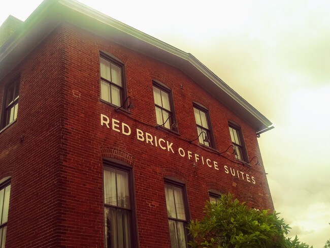
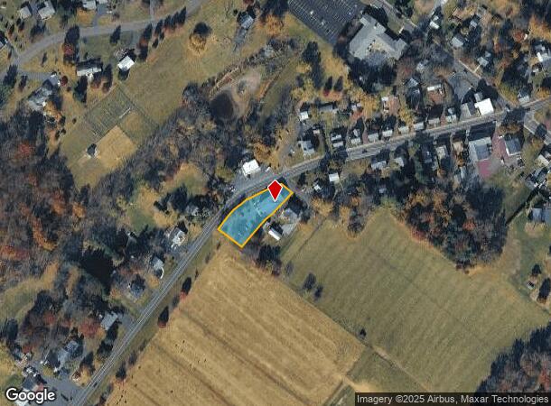
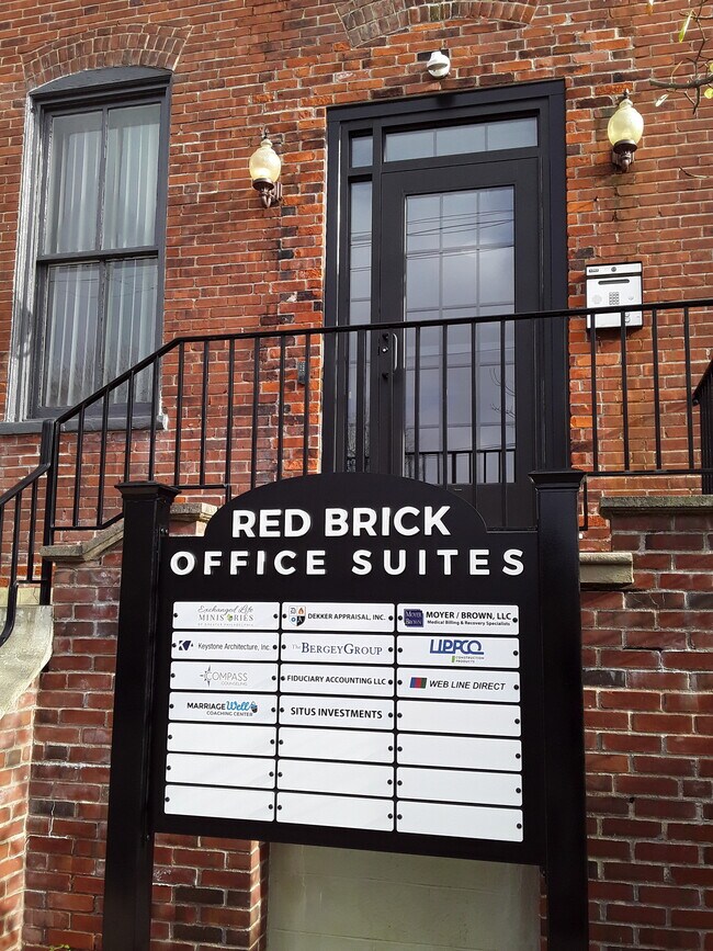
1259 Route 113
15-019-033
Village Of Blooming Glen
Officebuilding
LOT SW COR SR113 & HAMILT ON ST 284X40
X
Bucks
42091C0135G
Pennsylvania
2024
0.26 AC
2025
Upper Bucks County
102102
Philadelphia
5,120 SF
Philadelphia-Camden-Wilmington, PA-NJ-DE-MD
DEMOGRAPHICS near 1259 Route 113
1 Mile
3 Mile
5 Mile
2024 Total Population
648
29,156
53,711
2029 Population
645
29,176
53,618
Pop Growth 2024-2029
(0.46%)
+ 0.07%
(0.17%)
Average Age
47
42
42
2024 Total Households
257
11,062
20,424
HH Growth 2024-2029
(0.78%)
+ 0.14%
(0.15%)
Median Household Inc
$104,750
$106,405
$104,483
Avg Household Size
2.50
2.60
2.60
2024 Avg HH Vehicles
3.00
2.00
2.00
Median Home Value
$470,754
$365,201
$378,955
Median Year Built
1964
1978
1978
Nearby Places
Map Layers
Map Styles
 Street
 Aerial
- Restaurants
- Banks
- Shops
- Fitness
- Groceries
PUBLIC TRANSPORTATION
COMMUTER RAIL
Chalfont (R5 - Southeastern Pennsylvania Transportation Authority Regional Rail (SEPTA Regional Rail))
DRIVE
WALK
Distance
Chalfont (R5 - Southeastern Pennsylvania Transportation Authority Regional Rail (SEPTA Regional Rail))
14 min
7.6 mi
New Britain (R5 - Southeastern Pennsylvania Transportation Authority Regional Rail (SEPTA Regional Rail))
DRIVE
WALK
Distance
New Britain (R5 - Southeastern Pennsylvania Transportation Authority Regional Rail (SEPTA Regional Rail))
16 min
7.6 mi
AIRPORT
Lehigh Valley International
DRIVE
WALK
Distance
Lehigh Valley International
51 min
29.5 mi
Trenton Mercer
DRIVE
WALK
Distance
Trenton Mercer
51 min
30.2 mi
Freight Ports
Port of Philadelphia
DRIVE
WALK
Distance
Port of Philadelphia
55 min
33.1 mi
SALE & LEASE HISTORY
LISTING DATE
SALE/LEASE

Sep 24, 2016
For Sale
Sep 05, 2019
For Lease
Oct 21, 2016
For Lease
May 09, 2019
For Lease
Nearby Properties
Address
Land Use
TOTAL SIZE
Lot Size
Zoning
Address
Land Use
TOTAL SIZE
Lot Size
Zoning
256,512 SF
21.31 AC
CR
Address
Land Use
TOTAL SIZE
Lot Size
Zoning
1,261,187 SF
13.86 AC
CR
Address
Land Use
TOTAL SIZE
Lot Size
Zoning
92,018 SF
22.18 AC
I2
Address
Land Use
TOTAL SIZE
Lot Size
Zoning
131,218 SF
14.23 AC
PRD
Address
Land Use
TOTAL SIZE
Lot Size
Zoning
61,589 SF
10.81 AC
C2
Address
Land Use
TOTAL SIZE
Lot Size
Zoning
63,433 SF
8.20 AC
CO
Address
Land Use
TOTAL SIZE
Lot Size
Zoning
13,858 SF
9.62 AC
R1
Address
Land Use
TOTAL SIZE
Lot Size
Zoning
132,250 SF
28.32 AC
RR
Address
Land Use
TOTAL SIZE
Lot Size
Zoning
7.61 AC
CR
Address
Land Use
TOTAL SIZE
Lot Size
Zoning
105,840 SF
2.42 AC
R1B
Address
Land Use
TOTAL SIZE
Lot Size
Zoning
45,960 SF
0.36 AC
C2
Address
Land Use
TOTAL SIZE
Lot Size
Zoning
101,920 SF
21.05 AC
R1B
Address
Land Use
TOTAL SIZE
Lot Size
Zoning
39,966 SF
2.78 AC
I2
Address
Land Use
TOTAL SIZE
Lot Size
Zoning
40,000 SF
8.55 AC
I
Address
Land Use
TOTAL SIZE
Lot Size
Zoning
55,077 SF
7.22 AC
C2
Address
Land Use
TOTAL SIZE
Lot Size
Zoning
52,819 SF
15.35 AC
CR
Address
Land Use
TOTAL SIZE
Lot Size
Zoning
2,538 SF
4.96 AC
CR
Address
Land Use
TOTAL SIZE
Lot Size
Zoning
12,000 SF
128.21 AC
I1
Address
Land Use
TOTAL SIZE
Lot Size
Zoning
12,994 SF
3.89 AC
R2
Address
Land Use
TOTAL SIZE
Lot Size
Zoning
13,600 SF
3.95 AC
R1
Address
Land Use
TOTAL SIZE
Lot Size
Zoning
20,106 SF
6.49 AC
A
Address
Land Use
TOTAL SIZE
Lot Size
Zoning
41,460 SF
4.90 AC
R1
Address
Land Use
TOTAL SIZE
Lot Size
Zoning
35,200 SF
2.54 AC
C2
Address
Land Use
TOTAL SIZE
Lot Size
Zoning
9,680 SF
57.74 AC
Q
Address
Land Use
TOTAL SIZE
Lot Size
Zoning
5,525 SF
2.57 AC
PC2
Address
Land Use
TOTAL SIZE
Lot Size
Zoning
12,788 SF
1.88 AC
C1
Address
Land Use
TOTAL SIZE
Lot Size
Zoning
14,601 SF
1.84 AC
C2
Address
Land Use
TOTAL SIZE
Lot Size
Zoning
6,810 SF
0.35 AC
R2
Address
Land Use
TOTAL SIZE
Lot Size
Zoning
16,520 SF
3.38 AC
R1
Address
Land Use
TOTAL SIZE
Lot Size
Zoning
12,859 SF
2.19 AC
PC2
The World's #1 Commercial Real Estate Marketplace
Connect with us
© 2025 CoStar Group
The information above has been obtained from sources believed reliable. While we do not doubt its accuracy we have not verified it and make no guarantee, warranty or representation about it. It is your responsibility to independently confirm its accuracy and completeness. Any projections, opinions, assumptions, or estimates used are for example only and do not represent the current or future performance of the property. The value of this transaction to you depends on tax and other factors which should be evaluated by your tax, financial, and legal advisors. You and your advisors should conduct a careful, independent investigation of the property to determine to your satisfaction the suitability of the property for your needs.