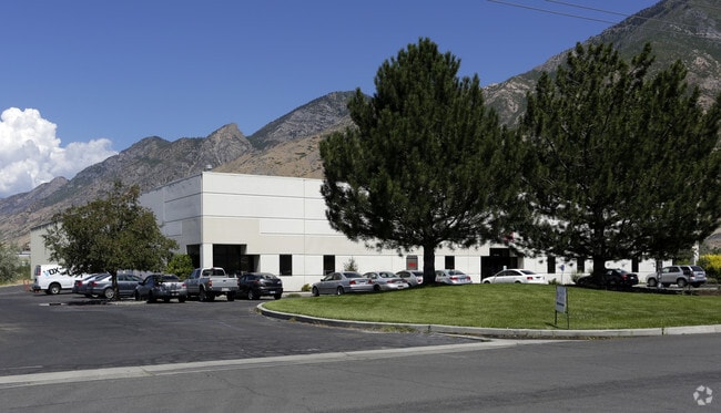
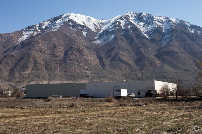
Property Record
1260 W 1650 N, Springville, UT 84663
NEARBY LISTINGS FOR SALE OR LEASE
Property Detail
1260 W 1650 N
Provo-Orem, UT
Upper Whittemore Mtn Hm
23-001-0112
COM N 603.11 FT & W 1651.28 FT FR S 1/4 COR. SEC. 20, T7S, R3E, SLB&M.; N 87 DEG 25 8 W 300 FT; N 0 DEG 25 6 W 290.4 FT; S 87 DEG 25 8 E 300 FT; S 0 DEG 25 6 E 290.4 FT TO BEG. AREA 1.997 AC.
Commercialnec
Utah
2024
Utah
2025
2 AC
980500
Utah County
43,685 SF
Salt Lake City
DEMOGRAPHICS near 1260 W 1650 N
1 Mile
3 Mile
5 Mile
2024 Total Population
874
48,306
138,520
2029 Population
1,019
56,325
161,769
Pop Growth 2024-2029
+ 16.59%
+ 16.60%
+ 16.78%
Average Age
29
31
30
2024 Total Households
230
14,953
42,406
HH Growth 2024-2029
+ 16.96%
+ 16.97%
+ 17.22%
Median Household Inc
$76,538
$69,356
$62,160
Avg Household Size
3.60
3.10
3.10
2024 Avg HH Vehicles
2.00
2.00
2.00
Median Home Value
$393,420
$377,697
$412,142
Median Year Built
2002
1993
1988
Nearby Places
Map Layers
Map Styles
 Street
 Aerial
- Restaurants
- Banks
- Shops
- Fitness
- Groceries
PUBLIC TRANSPORTATION
COMMUTER RAIL
DRIVE
WALK
Distance
7 min
4.1 mi
DRIVE
WALK
Distance
8 min
4.1 mi
AIRPORT
Provo Municipal
DRIVE
WALK
Distance
Provo Municipal
12 min
6.0 mi
SALE & LEASE HISTORY
LISTING DATE
SALE/LEASE

Oct 16, 2018
For Sale
Jun 04, 2018
For Lease
Jan 03, 2024
For Lease
Nearby Properties
Address
Land Use
TOTAL SIZE
Lot Size
Zoning
Address
Land Use
TOTAL SIZE
Lot Size
Zoning
442,598 SF
22.94 AC
Address
Land Use
TOTAL SIZE
Lot Size
Zoning
138,990 SF
2.87 AC
Address
Land Use
TOTAL SIZE
Lot Size
Zoning
297,467 SF
16.87 AC
Address
Land Use
TOTAL SIZE
Lot Size
Zoning
69,236 SF
30.28 AC
Address
Land Use
TOTAL SIZE
Lot Size
Zoning
286,188 SF
13.63 AC
Address
Land Use
TOTAL SIZE
Lot Size
Zoning
263,859 SF
12.80 AC
Address
Land Use
TOTAL SIZE
Lot Size
Zoning
269,742 SF
16.30 AC
Address
Land Use
TOTAL SIZE
Lot Size
Zoning
671,002 SF
59.02 AC
Address
Land Use
TOTAL SIZE
Lot Size
Zoning
370,735 SF
18.54 AC
Address
Land Use
TOTAL SIZE
Lot Size
Zoning
222,848 SF
11.14 AC
Address
Land Use
TOTAL SIZE
Lot Size
Zoning
301,852 SF
20.24 AC
Address
Land Use
TOTAL SIZE
Lot Size
Zoning
208,492 SF
12.49 AC
Address
Land Use
TOTAL SIZE
Lot Size
Zoning
177,428 SF
9.83 AC
Address
Land Use
TOTAL SIZE
Lot Size
Zoning
210,644 SF
19.55 AC
Address
Land Use
TOTAL SIZE
Lot Size
Zoning
125,729 SF
12.84 AC
Address
Land Use
TOTAL SIZE
Lot Size
Zoning
29,819 SF
13.51 AC
Address
Land Use
TOTAL SIZE
Lot Size
Zoning
386,576 SF
128.19 AC
Address
Land Use
TOTAL SIZE
Lot Size
Zoning
240,674 SF
19.41 AC
Address
Land Use
TOTAL SIZE
Lot Size
Zoning
238,651 SF
14.45 AC
Address
Land Use
TOTAL SIZE
Lot Size
Zoning
124,986 SF
8.67 AC
Address
Land Use
TOTAL SIZE
Lot Size
Zoning
151,447 SF
16.14 AC
Address
Land Use
TOTAL SIZE
Lot Size
Zoning
141,566 SF
7.89 AC
Address
Land Use
TOTAL SIZE
Lot Size
Zoning
231,991 SF
13.76 AC
Address
Land Use
TOTAL SIZE
Lot Size
Zoning
79,260 SF
5.24 AC
Address
Land Use
TOTAL SIZE
Lot Size
Zoning
151,447 SF
8.61 AC
Address
Land Use
TOTAL SIZE
Lot Size
Zoning
195,248 SF
13.20 AC
Address
Land Use
TOTAL SIZE
Lot Size
Zoning
128,650 SF
10 AC
Address
Land Use
TOTAL SIZE
Lot Size
Zoning
120,613 SF
5.13 AC
Address
Land Use
TOTAL SIZE
Lot Size
Zoning
170,273 SF
9.19 AC
Address
Land Use
TOTAL SIZE
Lot Size
Zoning
265,411 SF
19.28 AC
The World's #1 Commercial Real Estate Marketplace
Connect with us
© 2025 CoStar Group
The information above has been obtained from sources believed reliable. While we do not doubt its accuracy we have not verified it and make no guarantee, warranty or representation about it. It is your responsibility to independently confirm its accuracy and completeness. Any projections, opinions, assumptions, or estimates used are for example only and do not represent the current or future performance of the property. The value of this transaction to you depends on tax and other factors which should be evaluated by your tax, financial, and legal advisors. You and your advisors should conduct a careful, independent investigation of the property to determine to your satisfaction the suitability of the property for your needs.