Property Record
127 E Lexington Ave, El Cajon, CA 92020


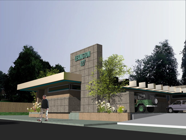

Property Detail
127 E Lexington Ave
488-200-02
BLK 6 LOT 1 W 38 FT OF N 100 FT LOT 2 & E 38 FT OF N 100 FT OF TR 000597
Storesoffices
San Diego
O-P
California
B and X Area of moderate flood hazard, usually the area between the limits of the 100-year and 500-year floods.
1,2
2024
0.18 AC
2025
East County
015802
San Diego
3,624 SF
San Diego-Chula Vista-Carlsbad, CA
NEARBY LISTINGS FOR SALE OR LEASE
DEMOGRAPHICS near 127 E Lexington Ave
1 mile
3 mile
5 mile
2025 Total Population
41,911
158,449
346,373
2030 Population
42,003
158,339
346,158
Pop Growth 2025-2030
+ 0.22%
(0.07%)
(0.06%)
Average Age
37
39
40
2025 Total Households
13,830
54,131
122,800
HH Growth 2025-2030
+ 0.06%
(0.25%)
(0.20%)
Median Household Inc
$60,050
$81,335
$93,733
Avg Household Size
2.90
2.80
2.70
2025 Avg HH Vehicles
2.00
2.00
2.00
Median Home Value
$619,426
$743,529
$745,234
Median Year Built
1974
1972
1974
Nearby Places
Map Layers
Map Styles
 Street
 Aerial
Layers
 Traffic
 Biking
Places
Listings with unknown addresses are not visible on the map
- Restaurants
- Banks
- Shops
- Fitness
- Groceries
PUBLIC TRANSPORTATION
AIRPORT
San Diego International
Drive
Walk
Distance
San Diego International
24 min
16.7 mi
Freight Ports
Port of San Diego
Drive
Walk
Distance
Port of San Diego
23 min
15.7 mi
SALE & LEASE HISTORY
LISTING DATE
SALE/LEASE

Sep 29, 2016
For Lease
Dec 17, 2025
For Sale
Nearby Properties
Address
Land Use
TOTAL SIZE
Lot Size
Zoning
Address
Land Use
TOTAL SIZE
Lot Size
Zoning
30.38 AC
RB
Address
Land Use
TOTAL SIZE
Lot Size
Zoning
6.84 AC
M
Address
Land Use
TOTAL SIZE
Lot Size
Zoning
8.24 AC
RU
Address
Land Use
TOTAL SIZE
Lot Size
Zoning
7.46 AC
RM-2200
Address
Land Use
TOTAL SIZE
Lot Size
Zoning
5.90 AC
RM-2200
Address
Land Use
TOTAL SIZE
Lot Size
Zoning
39.17 AC
C-R
Address
Land Use
TOTAL SIZE
Lot Size
Zoning
8.82 AC
RM-2200
Address
Land Use
TOTAL SIZE
Lot Size
Zoning
13.48 AC
CC-1-3
Address
Land Use
TOTAL SIZE
Lot Size
Zoning
6.12 AC
RM-2200
Address
Land Use
TOTAL SIZE
Lot Size
Zoning
Address
Land Use
TOTAL SIZE
Lot Size
Zoning
5.83 AC
RM-2200
Address
Land Use
TOTAL SIZE
Lot Size
Zoning
92,988 SF
6.12 AC
RB
Address
Land Use
TOTAL SIZE
Lot Size
Zoning
9.38 AC
RU
Address
Land Use
TOTAL SIZE
Lot Size
Zoning
5.17 AC
R3
Address
Land Use
TOTAL SIZE
Lot Size
Zoning
5.77 AC
RM-2200
Address
Land Use
TOTAL SIZE
Lot Size
Zoning
64,900 SF
4.55 AC
RM-2200
Address
Land Use
TOTAL SIZE
Lot Size
Zoning
83,198 SF
5 AC
RM-2200
Address
Land Use
TOTAL SIZE
Lot Size
Zoning
5.45 AC
R14
Address
Land Use
TOTAL SIZE
Lot Size
Zoning
4.39 AC
RM-2200
Address
Land Use
TOTAL SIZE
Lot Size
Zoning
3.80 AC
NC/R14
Address
Land Use
TOTAL SIZE
Lot Size
Zoning
4.75 AC
C-6
Address
Land Use
TOTAL SIZE
Lot Size
Zoning
4.69 AC
RU
Address
Land Use
TOTAL SIZE
Lot Size
Zoning
81,896 SF
3.74 AC
RM-2200
Address
Land Use
TOTAL SIZE
Lot Size
Zoning
95,024 SF
2.89 AC
RM-2200
Address
Land Use
TOTAL SIZE
Lot Size
Zoning
3.51 AC
RM-2200
Address
Land Use
TOTAL SIZE
Lot Size
Zoning
3.33 AC
R22
Address
Land Use
TOTAL SIZE
Lot Size
Zoning
77,930 SF
2.34 AC
O-P
Address
Land Use
TOTAL SIZE
Lot Size
Zoning
16.33 AC
C-R
Address
Land Use
TOTAL SIZE
Lot Size
Zoning
1.89 AC
C-R
Address
Land Use
TOTAL SIZE
Lot Size
Zoning
86,578 SF
4.26 AC
M
The World's #1 Commercial Real Estate Marketplace
Connect with us
© 2026 CoStar Group
The information above has been obtained from sources believed reliable. While we do not doubt its accuracy we have not verified it and make no guarantee, warranty or representation about it. It is your responsibility to independently confirm its accuracy and completeness. Any projections, opinions, assumptions, or estimates used are for example only and do not represent the current or future performance of the property. The value of this transaction to you depends on tax and other factors which should be evaluated by your tax, financial, and legal advisors. You and your advisors should conduct a careful, independent investigation of the property to determine to your satisfaction the suitability of the property for your needs.