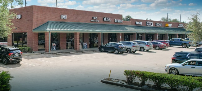
Property Record
1270 Crabb River Rd, Richmond, TX 77469

Property Detail
1270 Crabb River Rd
Houston-Pasadena-The Woodlands, TX
0049 J KUYKENDALL, ACRES 1.71, GREATWOOD RETAIL PHASE ONE (C7-B)
0049-00-000-0657-901
FORT BEND
Commercialnec
Texas
2024
1.71 AC
2025
Far New Territory
674603
Houston
14,300 SF
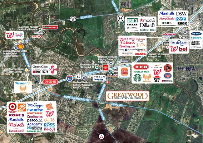
NEARBY LISTINGS FOR SALE OR LEASE
DEMOGRAPHICS near 1270 Crabb River Rd
1 mile
3 mile
5 mile
2025 Total Population
13,453
62,550
146,906
2030 Population
15,138
70,799
166,655
Pop Growth 2025-2030
+ 12.53%
+ 13.19%
+ 13.44%
Average Age
40
39
39
2025 Total Households
4,493
20,704
48,517
HH Growth 2025-2030
+ 12.93%
+ 13.67%
+ 13.93%
Median Household Inc
$116,321
$126,136
$120,921
Avg Household Size
3.00
3.00
3.00
2025 Avg HH Vehicles
2.00
2.00
2.00
Median Home Value
$342,843
$394,397
$412,741
Median Year Built
1997
2006
2006
Nearby Places
Map Layers
Map Styles
 Street
 Aerial
Layers
 Traffic
 Biking
Places
Listings with unknown addresses are not visible on the map
- Restaurants
- Banks
- Shops
- Fitness
- Groceries
PUBLIC TRANSPORTATION
AIRPORT
William P Hobby
Drive
Walk
Distance
William P Hobby
46 min
32.7 mi
Freight Ports
Port of Houston
Drive
Walk
Distance
Port of Houston
48 min
33.4 mi
SALE & LEASE HISTORY
LISTING DATE
SALE/LEASE

Sep 25, 2016
For Lease
Nov 20, 2025
For Sale
May 20, 2025
For Sale
Dec 04, 2018
For Sale
Apr 04, 2019
For Sale
Nearby Properties
Address
Land Use
TOTAL SIZE
Lot Size
Zoning
Address
Land Use
TOTAL SIZE
Lot Size
Zoning
401,314 SF
16.61 AC
Address
Land Use
TOTAL SIZE
Lot Size
Zoning
189,381 SF
167.45 AC
Address
Land Use
TOTAL SIZE
Lot Size
Zoning
133,259 SF
9.99 AC
Address
Land Use
TOTAL SIZE
Lot Size
Zoning
11.65 AC
Address
Land Use
TOTAL SIZE
Lot Size
Zoning
573,314 SF
115.57 AC
Address
Land Use
TOTAL SIZE
Lot Size
Zoning
203,739 SF
13.28 AC
Address
Land Use
TOTAL SIZE
Lot Size
Zoning
85,021 SF
12 AC
Address
Land Use
TOTAL SIZE
Lot Size
Zoning
102,715 SF
14.99 AC
Address
Land Use
TOTAL SIZE
Lot Size
Zoning
10,000,000 SF
54.91 AC
YQS
Address
Land Use
TOTAL SIZE
Lot Size
Zoning
89,753 SF
10.61 AC
Address
Land Use
TOTAL SIZE
Lot Size
Zoning
Address
Land Use
TOTAL SIZE
Lot Size
Zoning
4,084 SF
680.16 AC
QSOT
Address
Land Use
TOTAL SIZE
Lot Size
Zoning
312,108 SF
24.39 AC
Address
Land Use
TOTAL SIZE
Lot Size
Zoning
Address
Land Use
TOTAL SIZE
Lot Size
Zoning
126,080 SF
0.76 AC
Address
Land Use
TOTAL SIZE
Lot Size
Zoning
Address
Land Use
TOTAL SIZE
Lot Size
Zoning
Address
Land Use
TOTAL SIZE
Lot Size
Zoning
16.48 AC
Address
Land Use
TOTAL SIZE
Lot Size
Zoning
86,856 SF
10 AC
X
Address
Land Use
TOTAL SIZE
Lot Size
Zoning
Address
Land Use
TOTAL SIZE
Lot Size
Zoning
88,728 SF
5.04 AC
Address
Land Use
TOTAL SIZE
Lot Size
Zoning
87,094 SF
12.50 AC
QYS
Address
Land Use
TOTAL SIZE
Lot Size
Zoning
107,849 SF
6.75 AC
SQ
Address
Land Use
TOTAL SIZE
Lot Size
Zoning
Address
Land Use
TOTAL SIZE
Lot Size
Zoning
9.99 AC
Address
Land Use
TOTAL SIZE
Lot Size
Zoning
60,728 SF
5.59 AC
Address
Land Use
TOTAL SIZE
Lot Size
Zoning
60,391 SF
5.50 AC
Address
Land Use
TOTAL SIZE
Lot Size
Zoning
78,406 SF
8.31 AC
Address
Land Use
TOTAL SIZE
Lot Size
Zoning
99.98 AC
Address
Land Use
TOTAL SIZE
Lot Size
Zoning
116,000 SF
2.29 AC
The World's #1 Commercial Real Estate Marketplace
Connect with us
© 2026 CoStar Group
The information above has been obtained from sources believed reliable. While we do not doubt its accuracy we have not verified it and make no guarantee, warranty or representation about it. It is your responsibility to independently confirm its accuracy and completeness. Any projections, opinions, assumptions, or estimates used are for example only and do not represent the current or future performance of the property. The value of this transaction to you depends on tax and other factors which should be evaluated by your tax, financial, and legal advisors. You and your advisors should conduct a careful, independent investigation of the property to determine to your satisfaction the suitability of the property for your needs.