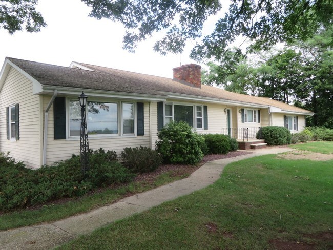
Property Record
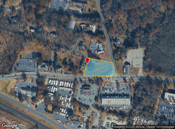
1273 Rt 28 & Lamington Rd, Branchburg, NJ 08876

NEARBY LISTINGS FOR SALE OR LEASE
Property Detail
1273 Rt 28 & Lamington Rd
05-00005-0000-00025
ADDITIONAL LOTS: 2206
Officebuilding
Somerset
X
New Jersey
34019C0277F
25
2024
0.89 AC
2025
Route 22 West
050600
Northern New Jersey
2,245 SF
Newark, NJ-PA
DEMOGRAPHICS near 1273 Rt 28 & Lamington Rd
1 Mile
3 Mile
5 Mile
2024 Total Population
1,491
26,129
74,758
2029 Population
1,530
26,256
75,058
Pop Growth 2024-2029
+ 2.62%
+ 0.49%
+ 0.40%
Average Age
44
43
43
2024 Total Households
584
9,546
29,008
HH Growth 2024-2029
+ 2.57%
+ 0.40%
+ 0.38%
Median Household Inc
$163,109
$150,211
$134,191
Avg Household Size
2.60
2.70
2.50
2024 Avg HH Vehicles
2.00
2.00
2.00
Median Home Value
$665,129
$517,081
$486,274
Median Year Built
1971
1987
1983
Nearby Places
Map Layers
Map Styles
 Street
 Aerial
- Restaurants
- Banks
- Shops
- Fitness
- Groceries
PUBLIC TRANSPORTATION
COMMUTER RAIL
North Branch (Raritan Valley Line - NJ Transit Commuter Rail (NJ Transit))
DRIVE
WALK
Distance
North Branch (Raritan Valley Line - NJ Transit Commuter Rail (NJ Transit))
5 min
1.9 mi
White House (Raritan Valley Line - NJ Transit Commuter Rail (NJ Transit))
DRIVE
WALK
Distance
White House (Raritan Valley Line - NJ Transit Commuter Rail (NJ Transit))
8 min
4.6 mi
AIRPORT
Trenton Mercer
DRIVE
WALK
Distance
Trenton Mercer
56 min
33.8 mi
Newark Liberty International
DRIVE
WALK
Distance
Newark Liberty International
45 min
35.8 mi
Freight Ports
New York Container Terminal
DRIVE
WALK
Distance
New York Container Terminal
48 min
37.1 mi
SALE & LEASE HISTORY
LISTING DATE
SALE/LEASE

Sep 23, 2016
For Sale
Nearby Properties
Address
Land Use
TOTAL SIZE
Lot Size
Zoning
Address
Land Use
TOTAL SIZE
Lot Size
Zoning
63.86 AC
I2
Address
Land Use
TOTAL SIZE
Lot Size
Zoning
236.88 AC
CF
Address
Land Use
TOTAL SIZE
Lot Size
Zoning
47.50 AC
M1
Address
Land Use
TOTAL SIZE
Lot Size
Zoning
4,397 SF
26.86 AC
I-1
Address
Land Use
TOTAL SIZE
Lot Size
Zoning
54.31 AC
P-2
Address
Land Use
TOTAL SIZE
Lot Size
Zoning
34.26 AC
Address
Land Use
TOTAL SIZE
Lot Size
Zoning
18.46 AC
I
Address
Land Use
TOTAL SIZE
Lot Size
Zoning
20 AC
I-1
Address
Land Use
TOTAL SIZE
Lot Size
Zoning
38.79 AC
I-1
Address
Land Use
TOTAL SIZE
Lot Size
Zoning
23.64 AC
I,IP
Address
Land Use
TOTAL SIZE
Lot Size
Zoning
13.48 AC
I2
Address
Land Use
TOTAL SIZE
Lot Size
Zoning
118.92 AC
R10
Address
Land Use
TOTAL SIZE
Lot Size
Zoning
20.18 AC
I-1
Address
Land Use
TOTAL SIZE
Lot Size
Zoning
25.08 AC
I-1
Address
Land Use
TOTAL SIZE
Lot Size
Zoning
10.34 AC
RS-1
Address
Land Use
TOTAL SIZE
Lot Size
Zoning
14.68 AC
C3
Address
Land Use
TOTAL SIZE
Lot Size
Zoning
12.05 AC
I-IP
Address
Land Use
TOTAL SIZE
Lot Size
Zoning
23.11 AC
I-1
Address
Land Use
TOTAL SIZE
Lot Size
Zoning
18.81 AC
O
Address
Land Use
TOTAL SIZE
Lot Size
Zoning
25.75 AC
I-1
Address
Land Use
TOTAL SIZE
Lot Size
Zoning
5.98 AC
I-IP
Address
Land Use
TOTAL SIZE
Lot Size
Zoning
22.84 AC
I-1
Address
Land Use
TOTAL SIZE
Lot Size
Zoning
13.99 AC
I-2
Address
Land Use
TOTAL SIZE
Lot Size
Zoning
12.15 AC
I-2
Address
Land Use
TOTAL SIZE
Lot Size
Zoning
8.95 AC
C3
Address
Land Use
TOTAL SIZE
Lot Size
Zoning
12.18 AC
I-IP
Address
Land Use
TOTAL SIZE
Lot Size
Zoning
1,356 SF
5.05 AC
RS2
Address
Land Use
TOTAL SIZE
Lot Size
Zoning
18,288 SF
3.78 AC
I-IP
Address
Land Use
TOTAL SIZE
Lot Size
Zoning
8.69 AC
I-2
Address
Land Use
TOTAL SIZE
Lot Size
Zoning
12.83 AC
I-1
The World's #1 Commercial Real Estate Marketplace
Connect with us
© 2025 CoStar Group
The information above has been obtained from sources believed reliable. While we do not doubt its accuracy we have not verified it and make no guarantee, warranty or representation about it. It is your responsibility to independently confirm its accuracy and completeness. Any projections, opinions, assumptions, or estimates used are for example only and do not represent the current or future performance of the property. The value of this transaction to you depends on tax and other factors which should be evaluated by your tax, financial, and legal advisors. You and your advisors should conduct a careful, independent investigation of the property to determine to your satisfaction the suitability of the property for your needs.