Property Record
12770 E 38Th Ave, Denver, CO 80239

This Property Is For Sale
Property Detail
12770 E 38Th Ave
Denver-Aurora-Centennial, CO
UPLAND NORTH FLG #2 B2 PT L1 BEG SW COR L1 TH N02.2353W 301.44FT E 260.31FT S 317.33FT N86.0330W 247.91FT TPOB
1252-01-009
DENVER
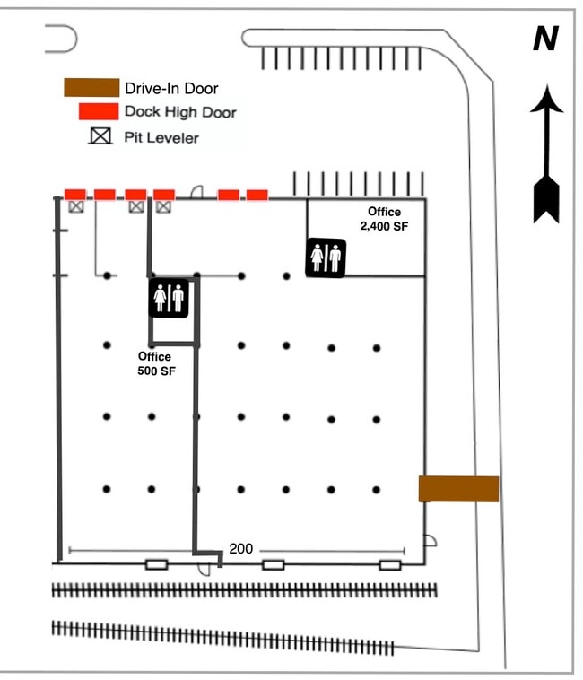
Warehouse
Colorado
I-B
1
2024
1.80 AC
2025
SW DIA/Pena Blvd
008306
Denver
40,000 SF
NEARBY LISTINGS FOR SALE OR LEASE
DEMOGRAPHICS near 12770 E 38Th Ave
1 mile
3 mile
5 mile
2024 Total Population
11,558
124,614
296,411
2029 Population
11,841
126,873
301,488
Pop Growth 2024-2029
+ 2.45%
+ 1.81%
+ 1.71%
Average Age
35
34
35
2024 Total Households
3,379
39,985
104,125
HH Growth 2024-2029
+ 2.40%
+ 1.98%
+ 1.77%
Median Household Inc
$58,758
$67,049
$70,262
Avg Household Size
3.00
2.90
2.70
2024 Avg HH Vehicles
2.00
2.00
2.00
Median Home Value
$329,728
$383,680
$406,348
Median Year Built
1981
1984
1984
Nearby Places
Map Layers
Map Styles
 Street
 Aerial
Transit
 Traffic
 Biking
Places
Listings with unknown addresses are not visible on the map
- Restaurants
- Banks
- Shops
- Fitness
- Groceries
PUBLIC TRANSPORTATION
COMMUTER RAIL
Peoria Station Track 1 (Union Station to Denver Airport Station - Regional Transportation District)
Drive
Walk
Distance
Peoria Station Track 1 (Union Station to Denver Airport Station - Regional Transportation District)
2 min
0.7 mi
Peoria Station Track 2 (Union Station to Denver Airport Station - Regional Transportation District)
Drive
Walk
Distance
Peoria Station Track 2 (Union Station to Denver Airport Station - Regional Transportation District)
2 min
0.7 mi
AIRPORT
Denver International
Drive
Walk
Distance
Denver International
21 min
15.4 mi
Freight Ports
Tulsa Port Of Catoosa
Drive
Walk
Distance
Tulsa Port Of Catoosa
718 min
700.9 mi
Nearby Properties
Address
Land Use
TOTAL SIZE
Lot Size
Zoning
Address
Land Use
TOTAL SIZE
Lot Size
Zoning
368,450 SF
48.59 AC
Address
Land Use
TOTAL SIZE
Lot Size
Zoning
353,829 SF
4.51 AC
Address
Land Use
TOTAL SIZE
Lot Size
Zoning
880,442 SF
67.95 AC
I-B
Address
Land Use
TOTAL SIZE
Lot Size
Zoning
244,271 SF
15.30 AC
Address
Land Use
TOTAL SIZE
Lot Size
Zoning
525,050 SF
105.06 AC
Address
Land Use
TOTAL SIZE
Lot Size
Zoning
169,941 SF
4.08 AC
I-B
Address
Land Use
TOTAL SIZE
Lot Size
Zoning
723,053 SF
32.44 AC
M-IMX-12
Address
Land Use
TOTAL SIZE
Lot Size
Zoning
269,025 SF
18.86 AC
M-RX-5
Address
Land Use
TOTAL SIZE
Lot Size
Zoning
87,346 SF
1.76 AC
RFBAD
Address
Land Use
TOTAL SIZE
Lot Size
Zoning
45,803 SF
1.96 AC
M-IMX-5
Address
Land Use
TOTAL SIZE
Lot Size
Zoning
335,757 SF
36.88 AC
CMP-EI2
Address
Land Use
TOTAL SIZE
Lot Size
Zoning
102,444 SF
3.76 AC
GTWY
Address
Land Use
TOTAL SIZE
Lot Size
Zoning
691,200 SF
38.09 AC
Address
Land Use
TOTAL SIZE
Lot Size
Zoning
109,982 SF
2.92 AC
M-IMX-12
Address
Land Use
TOTAL SIZE
Lot Size
Zoning
390,822 SF
13.47 AC
O-1
Address
Land Use
TOTAL SIZE
Lot Size
Zoning
57,392 SF
0.72 AC
Address
Land Use
TOTAL SIZE
Lot Size
Zoning
135,803 SF
3.36 AC
Address
Land Use
TOTAL SIZE
Lot Size
Zoning
273,184 SF
1.89 AC
Address
Land Use
TOTAL SIZE
Lot Size
Zoning
6.97 AC
C-MU-20
Address
Land Use
TOTAL SIZE
Lot Size
Zoning
651,423 SF
82.50 AC
I-2
Address
Land Use
TOTAL SIZE
Lot Size
Zoning
512,720 SF
42.32 AC
Address
Land Use
TOTAL SIZE
Lot Size
Zoning
131,544 SF
3.92 AC
Address
Land Use
TOTAL SIZE
Lot Size
Zoning
646,975 SF
32.60 AC
M-IMX-8
Address
Land Use
TOTAL SIZE
Lot Size
Zoning
269,622 SF
12.90 AC
Address
Land Use
TOTAL SIZE
Lot Size
Zoning
124,526 SF
10 AC
M-RH-3
Address
Land Use
TOTAL SIZE
Lot Size
Zoning
58,997 SF
2.05 AC
S-CC-5X
Address
Land Use
TOTAL SIZE
Lot Size
Zoning
400,000 SF
22.91 AC
I-0
Address
Land Use
TOTAL SIZE
Lot Size
Zoning
178,235 SF
1.38 AC
RFBAD
Address
Land Use
TOTAL SIZE
Lot Size
Zoning
92,598 SF
2.78 AC
G-TW
Address
Land Use
TOTAL SIZE
Lot Size
Zoning
74,966 SF
1.79 AC
The World's #1 Commercial Real Estate Marketplace
Connect with us
© 2026 CoStar Group
The information above has been obtained from sources believed reliable. While we do not doubt its accuracy we have not verified it and make no guarantee, warranty or representation about it. It is your responsibility to independently confirm its accuracy and completeness. Any projections, opinions, assumptions, or estimates used are for example only and do not represent the current or future performance of the property. The value of this transaction to you depends on tax and other factors which should be evaluated by your tax, financial, and legal advisors. You and your advisors should conduct a careful, independent investigation of the property to determine to your satisfaction the suitability of the property for your needs.