Property Record
12820 Main St, Frisco, TX 75035


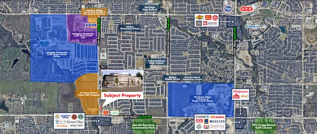
Property Detail
12820 Main St
Dallas-Fort Worth-Arlington, TX
NEC COIT AND MAIN ADDITION, BLK A, LOT 1
R-12710-00A-0010-1
COLLIN
Commercialnec
Texas
COMM
1
2025
1.43 AC
2025
Frisco
030511
Dallas/Ft Worth
4,462 SF
NEARBY LISTINGS FOR SALE OR LEASE
DEMOGRAPHICS near 12820 Main St
1 mile
3 mile
5 mile
2025 Total Population
11,152
128,058
339,728
2030 Population
13,084
146,118
387,325
Pop Growth 2025-2030
+ 17.32%
+ 14.10%
+ 14.01%
Average Age
34
36
37
2025 Total Households
3,096
41,870
119,711
HH Growth 2025-2030
+ 17.34%
+ 14.26%
+ 14.33%
Median Household Inc
$198,366
$151,880
$138,911
Avg Household Size
3.60
3.00
2.80
2025 Avg HH Vehicles
2.00
2.00
2.00
Median Home Value
$756,517
$634,179
$629,036
Median Year Built
2011
2008
2008
Nearby Places
Map Layers
Map Styles
 Street
 Aerial
Transit
 Traffic
 Biking
Places
Listings with unknown addresses are not visible on the map
- Restaurants
- Banks
- Shops
- Fitness
- Groceries
PUBLIC TRANSPORTATION
AIRPORT
Dallas Love Field
Drive
Walk
Distance
Dallas Love Field
38 min
27.6 mi
Dallas-Fort Worth International
Drive
Walk
Distance
Dallas-Fort Worth International
34 min
28.4 mi
Freight Ports
Port of Shreveport
Drive
Walk
Distance
Port of Shreveport
241 min
220.9 mi
Nearby Properties
Address
Land Use
TOTAL SIZE
Lot Size
Zoning
Address
Land Use
TOTAL SIZE
Lot Size
Zoning
741,280 SF
90.87 AC
Address
Land Use
TOTAL SIZE
Lot Size
Zoning
766,124 SF
62.04 AC
Address
Land Use
TOTAL SIZE
Lot Size
Zoning
761,346 SF
75.86 AC
Address
Land Use
TOTAL SIZE
Lot Size
Zoning
494,378 SF
57.29 AC
Address
Land Use
TOTAL SIZE
Lot Size
Zoning
535,339 SF
54.76 AC
Address
Land Use
TOTAL SIZE
Lot Size
Zoning
556,032 SF
24.46 AC
MF-M
Address
Land Use
TOTAL SIZE
Lot Size
Zoning
466,467 SF
46.81 AC
Address
Land Use
TOTAL SIZE
Lot Size
Zoning
584,548 SF
33.76 AC
MF
Address
Land Use
TOTAL SIZE
Lot Size
Zoning
493,621 SF
17 AC
APTS
Address
Land Use
TOTAL SIZE
Lot Size
Zoning
537,872 SF
36.28 AC
MF
Address
Land Use
TOTAL SIZE
Lot Size
Zoning
294,229 SF
32.11 AC
Address
Land Use
TOTAL SIZE
Lot Size
Zoning
483,386 SF
4.62 AC
MF-R
Address
Land Use
TOTAL SIZE
Lot Size
Zoning
410,262 SF
20.90 AC
MF-M
Address
Land Use
TOTAL SIZE
Lot Size
Zoning
472,446 SF
24.26 AC
MF
Address
Land Use
TOTAL SIZE
Lot Size
Zoning
505,541 SF
19.78 AC
SFR
Address
Land Use
TOTAL SIZE
Lot Size
Zoning
508,028 SF
14.61 AC
Address
Land Use
TOTAL SIZE
Lot Size
Zoning
357,097 SF
19.68 AC
MF-M
Address
Land Use
TOTAL SIZE
Lot Size
Zoning
390,948 SF
21.95 AC
MF-M
Address
Land Use
TOTAL SIZE
Lot Size
Zoning
345,998 SF
17.81 AC
MF-M
Address
Land Use
TOTAL SIZE
Lot Size
Zoning
332,295 SF
19.68 AC
MF-M
Address
Land Use
TOTAL SIZE
Lot Size
Zoning
424,266 SF
13.72 AC
MF-M
Address
Land Use
TOTAL SIZE
Lot Size
Zoning
386,153 SF
13.83 AC
Address
Land Use
TOTAL SIZE
Lot Size
Zoning
247,804 SF
23.84 AC
MD/2F
Address
Land Use
TOTAL SIZE
Lot Size
Zoning
357,411 SF
13.59 AC
MF-M
Address
Land Use
TOTAL SIZE
Lot Size
Zoning
339,685 SF
13.82 AC
MF
Address
Land Use
TOTAL SIZE
Lot Size
Zoning
300,789 SF
43.28 AC
Address
Land Use
TOTAL SIZE
Lot Size
Zoning
342,295 SF
14.37 AC
MF-H
Address
Land Use
TOTAL SIZE
Lot Size
Zoning
173,823 SF
19.77 AC
Address
Land Use
TOTAL SIZE
Lot Size
Zoning
283,040 SF
16 AC
MF-M
Address
Land Use
TOTAL SIZE
Lot Size
Zoning
254,467 SF
12.74 AC
MF
The World's #1 Commercial Real Estate Marketplace
Connect with us
© 2026 CoStar Group
The information above has been obtained from sources believed reliable. While we do not doubt its accuracy we have not verified it and make no guarantee, warranty or representation about it. It is your responsibility to independently confirm its accuracy and completeness. Any projections, opinions, assumptions, or estimates used are for example only and do not represent the current or future performance of the property. The value of this transaction to you depends on tax and other factors which should be evaluated by your tax, financial, and legal advisors. You and your advisors should conduct a careful, independent investigation of the property to determine to your satisfaction the suitability of the property for your needs.