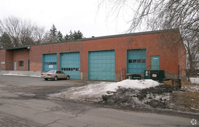
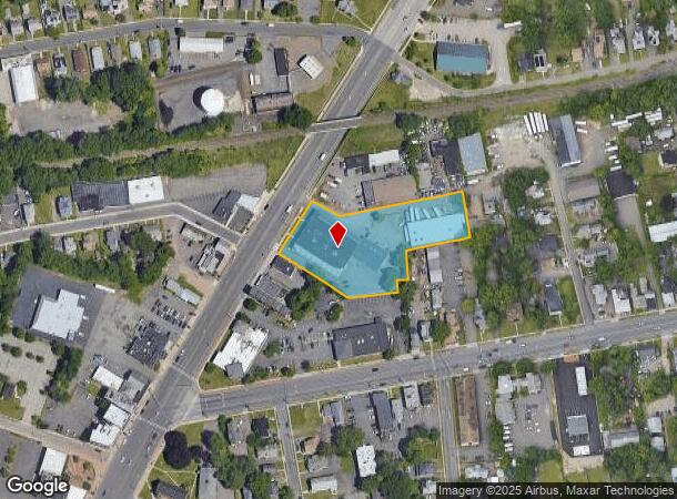
Property Record
1284 Main St, East Hartford, CT 06108
NEARBY LISTINGS FOR SALE OR LEASE
Property Detail
1284 Main St
EHAR-000014-000000-000306
Hartford
Commercialnec
Connecticut
X
306
09003C0368G
1.88 AC
2025
East Hartford
2025
Hartford
510400
Hartford-West Hartford-East Hartford, CT
DEMOGRAPHICS near 1284 Main St
1 Mile
3 Mile
5 Mile
2024 Total Population
9,658
96,447
247,440
2029 Population
9,604
96,651
246,338
Pop Growth 2024-2029
(0.56%)
+ 0.21%
(0.45%)
Average Age
39
37
39
2024 Total Households
3,765
39,420
98,555
HH Growth 2024-2029
(0.69%)
+ 0.47%
(0.35%)
Median Household Inc
$46,465
$43,960
$56,282
Avg Household Size
2.40
2.40
2.40
2024 Avg HH Vehicles
1.00
1.00
1.00
Median Home Value
$167,775
$176,491
$215,106
Median Year Built
1957
1961
1957
Nearby Places
Map Layers
Map Styles
 Street
 Aerial
- Restaurants
- Banks
- Shops
- Fitness
- Groceries
PUBLIC TRANSPORTATION
COMMUTER RAIL
Hartford Amtrak Station (Amtrak Hartford Line - Amtrak, Northeast Regional - Amtrak, Valley Flyer - Amtrak, Vermonter - Amtrak)
DRIVE
WALK
Distance
Hartford Amtrak Station (Amtrak Hartford Line - Amtrak, Northeast Regional - Amtrak, Valley Flyer - Amtrak, Vermonter - Amtrak)
5 min
2.6 mi
Hartford (Hartford Line - Hartford Line)
DRIVE
WALK
Distance
Hartford (Hartford Line - Hartford Line)
5 min
2.9 mi
AIRPORT
Bradley International
DRIVE
WALK
Distance
Bradley International
33 min
18.5 mi
Freight Ports
Port of New Haven
DRIVE
WALK
Distance
Port of New Haven
52 min
39.8 mi
Nearby Properties
Address
Land Use
TOTAL SIZE
Lot Size
Zoning
Address
Land Use
TOTAL SIZE
Lot Size
Zoning
147,644 SF
0.19 AC
CAMP
Address
Land Use
TOTAL SIZE
Lot Size
Zoning
173,601 SF
1.56 AC
DT-1
Address
Land Use
TOTAL SIZE
Lot Size
Zoning
516,804 SF
32.98 AC
CAMP
Address
Land Use
TOTAL SIZE
Lot Size
Zoning
482,566 SF
0.65 AC
DT-2
Address
Land Use
TOTAL SIZE
Lot Size
Zoning
15.73 AC
CAMP
Address
Land Use
TOTAL SIZE
Lot Size
Zoning
4.13 AC
DT-1
Address
Land Use
TOTAL SIZE
Lot Size
Zoning
213,017 SF
6.21 AC
DT-3
Address
Land Use
TOTAL SIZE
Lot Size
Zoning
149.23 AC
DDD1
Address
Land Use
TOTAL SIZE
Lot Size
Zoning
2.90 AC
DT-2
Address
Land Use
TOTAL SIZE
Lot Size
Zoning
112.42 AC
DDD1
Address
Land Use
TOTAL SIZE
Lot Size
Zoning
69.42 AC
CT R
Address
Land Use
TOTAL SIZE
Lot Size
Zoning
8.89 AC
MX-2
Address
Land Use
TOTAL SIZE
Lot Size
Zoning
29.35 AC
CAMP
Address
Land Use
TOTAL SIZE
Lot Size
Zoning
2,500 SF
74.98 AC
I-2
Address
Land Use
TOTAL SIZE
Lot Size
Zoning
584 AC
OS
Address
Land Use
TOTAL SIZE
Lot Size
Zoning
1,125,149 SF
1.14 AC
DT-1
Address
Land Use
TOTAL SIZE
Lot Size
Zoning
205,719 SF
12.15 AC
MX-2
Address
Land Use
TOTAL SIZE
Lot Size
Zoning
28.02 AC
CAMP
Address
Land Use
TOTAL SIZE
Lot Size
Zoning
9.92 AC
DDD1
Address
Land Use
TOTAL SIZE
Lot Size
Zoning
14.56 AC
SDD/BG
Address
Land Use
TOTAL SIZE
Lot Size
Zoning
235,476 SF
198.32 AC
CT R
Address
Land Use
TOTAL SIZE
Lot Size
Zoning
109,276 SF
11 AC
DDD1
Address
Land Use
TOTAL SIZE
Lot Size
Zoning
40,632 SF
1.10 AC
NX-1
Address
Land Use
TOTAL SIZE
Lot Size
Zoning
36.69 AC
R-5
Address
Land Use
TOTAL SIZE
Lot Size
Zoning
4.76 AC
MX-2
Address
Land Use
TOTAL SIZE
Lot Size
Zoning
6.63 AC
DT-1
Address
Land Use
TOTAL SIZE
Lot Size
Zoning
2.13 AC
DT-1
Address
Land Use
TOTAL SIZE
Lot Size
Zoning
4.50 AC
DT-1
Address
Land Use
TOTAL SIZE
Lot Size
Zoning
11.85 AC
MX-2
Address
Land Use
TOTAL SIZE
Lot Size
Zoning
2.04 AC
DT-3
The World's #1 Commercial Real Estate Marketplace
Connect with us
© 2025 CoStar Group
The information above has been obtained from sources believed reliable. While we do not doubt its accuracy we have not verified it and make no guarantee, warranty or representation about it. It is your responsibility to independently confirm its accuracy and completeness. Any projections, opinions, assumptions, or estimates used are for example only and do not represent the current or future performance of the property. The value of this transaction to you depends on tax and other factors which should be evaluated by your tax, financial, and legal advisors. You and your advisors should conduct a careful, independent investigation of the property to determine to your satisfaction the suitability of the property for your needs.