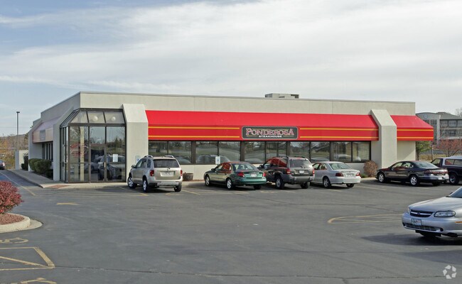
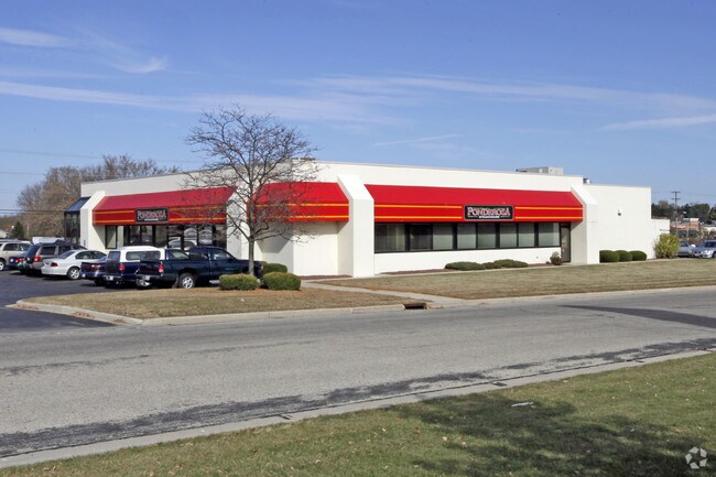
Property Record
1285 E Sumner St, Hartford, WI 53027

NEARBY LISTINGS FOR SALE OR LEASE
Property Detail
1285 E Sumner St
36-2203001008
Certified Survey Map No 3676
Commercialnec
PT OF SW CSM 3676 PAR 3 DOC 1550568 (HWY DOC 1365525)
X
Washington
55131C0228E
Wisconsin
2024
1.67 AC
2024
Washington West
440104
Milwaukee/Madison
4,980 SF
Milwaukee-Waukesha, WI
DEMOGRAPHICS near 1285 E Sumner St
1 Mile
3 Mile
5 Mile
2024 Total Population
6,704
20,538
29,781
2029 Population
6,909
21,172
30,614
Pop Growth 2024-2029
+ 3.06%
+ 3.09%
+ 2.80%
Average Age
43
41
41
2024 Total Households
3,023
8,607
12,225
HH Growth 2024-2029
+ 3.04%
+ 3.08%
+ 2.80%
Median Household Inc
$61,438
$70,034
$74,114
Avg Household Size
2.20
2.40
2.40
2024 Avg HH Vehicles
2.00
2.00
2.00
Median Home Value
$246,378
$248,223
$269,302
Median Year Built
1990
1991
1990
Nearby Places
Map Layers
Map Styles
 Street
 Aerial
- Restaurants
- Banks
- Shops
- Fitness
- Groceries
PUBLIC TRANSPORTATION
AIRPORT
General Mitchell International
DRIVE
WALK
Distance
General Mitchell International
60 min
43.1 mi
Freight Ports
Port Milwaukee
DRIVE
WALK
Distance
Port Milwaukee
54 min
39.3 mi
SALE & LEASE HISTORY
LISTING DATE
SALE/LEASE

Oct 03, 2020
For Sale
Nearby Properties
Address
Land Use
TOTAL SIZE
Lot Size
Zoning
Address
Land Use
TOTAL SIZE
Lot Size
Zoning
49,735 SF
9.99 AC
Address
Land Use
TOTAL SIZE
Lot Size
Zoning
13,314 SF
16.91 AC
Address
Land Use
TOTAL SIZE
Lot Size
Zoning
70,221 SF
7.09 AC
Address
Land Use
TOTAL SIZE
Lot Size
Zoning
94,819 SF
0.18 AC
Address
Land Use
TOTAL SIZE
Lot Size
Zoning
22,814 SF
8.85 AC
Address
Land Use
TOTAL SIZE
Lot Size
Zoning
20.24 AC
Address
Land Use
TOTAL SIZE
Lot Size
Zoning
11.63 AC
Address
Land Use
TOTAL SIZE
Lot Size
Zoning
184,928 SF
22.37 AC
Address
Land Use
TOTAL SIZE
Lot Size
Zoning
15,408 SF
9.39 AC
Address
Land Use
TOTAL SIZE
Lot Size
Zoning
57,888 SF
2.45 AC
Address
Land Use
TOTAL SIZE
Lot Size
Zoning
37,038 SF
1.02 AC
Address
Land Use
TOTAL SIZE
Lot Size
Zoning
8.10 AC
Address
Land Use
TOTAL SIZE
Lot Size
Zoning
6,620 SF
1.26 AC
Address
Land Use
TOTAL SIZE
Lot Size
Zoning
13.14 AC
Address
Land Use
TOTAL SIZE
Lot Size
Zoning
26,340 SF
5.01 AC
Address
Land Use
TOTAL SIZE
Lot Size
Zoning
5.03 AC
Address
Land Use
TOTAL SIZE
Lot Size
Zoning
5.09 AC
Address
Land Use
TOTAL SIZE
Lot Size
Zoning
36,686 SF
1.86 AC
Address
Land Use
TOTAL SIZE
Lot Size
Zoning
63,705 SF
6.85 AC
Address
Land Use
TOTAL SIZE
Lot Size
Zoning
55,326 SF
1.37 AC
Address
Land Use
TOTAL SIZE
Lot Size
Zoning
25,300 SF
9.57 AC
Address
Land Use
TOTAL SIZE
Lot Size
Zoning
14,276 SF
9.02 AC
Address
Land Use
TOTAL SIZE
Lot Size
Zoning
14,015 SF
2.50 AC
Address
Land Use
TOTAL SIZE
Lot Size
Zoning
15,408 SF
5.25 AC
Address
Land Use
TOTAL SIZE
Lot Size
Zoning
11,676 SF
1.13 AC
Address
Land Use
TOTAL SIZE
Lot Size
Zoning
28,326 SF
3.27 AC
Address
Land Use
TOTAL SIZE
Lot Size
Zoning
Address
Land Use
TOTAL SIZE
Lot Size
Zoning
10.85 AC
Address
Land Use
TOTAL SIZE
Lot Size
Zoning
7.96 AC
Address
Land Use
TOTAL SIZE
Lot Size
Zoning
184,483 SF
13.89 AC
The World's #1 Commercial Real Estate Marketplace
Connect with us
© 2026 CoStar Group
The information above has been obtained from sources believed reliable. While we do not doubt its accuracy we have not verified it and make no guarantee, warranty or representation about it. It is your responsibility to independently confirm its accuracy and completeness. Any projections, opinions, assumptions, or estimates used are for example only and do not represent the current or future performance of the property. The value of this transaction to you depends on tax and other factors which should be evaluated by your tax, financial, and legal advisors. You and your advisors should conduct a careful, independent investigation of the property to determine to your satisfaction the suitability of the property for your needs.