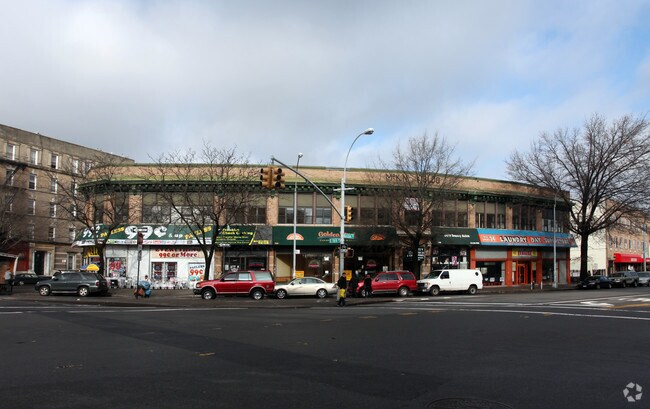
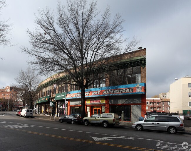
Property Record
1291 Boston Rd, Bronx, NY 10456


NEARBY LISTINGS FOR SALE OR LEASE
Property Detail
1291 Boston Rd
02934-0001
Bronx
Storebuilding
New York
X
1
3604970084F
0.27 AC
2024
Bronx
2025
Westchester/So Connecticut
015100
New York-Jersey City-White Plains, NY-NJ
23,282 SF
DEMOGRAPHICS near 1291 Boston Rd
1 mile
3 mile
5 mile
2024 Total Population
201,658
1,285,451
2,284,600
2029 Population
188,895
1,193,962
2,118,459
Pop Growth 2024-2029
(6.33%)
(7.12%)
(7.27%)
Average Age
36
38
39
2024 Total Households
67,553
462,645
880,189
HH Growth 2024-2029
(7.06%)
(7.71%)
(7.71%)
Median Household Inc
$33,331
$40,574
$52,888
Avg Household Size
2.80
2.60
2.50
2024 Avg HH Vehicles
.00
.00
.00
Median Home Value
$480,208
$521,195
$661,672
Median Year Built
1966
1949
1952
Nearby Places
Map Layers
Map Styles
 Street
 Aerial
Transit
 Traffic
 Biking
Places
Listings with unknown addresses are not visible on the map
- Restaurants
- Banks
- Shops
- Fitness
- Groceries
PUBLIC TRANSPORTATION
TRANSIT/SUBWAY
Freeman Street (2 - New York MTA Subway (The Subway), 5 - New York MTA Subway (The Subway))
Drive
Walk
Distance
Freeman Street (2 - New York MTA Subway (The Subway), 5 - New York MTA Subway (The Subway))
2 min
10 min
0.5 mi
Simpson Street (2 - New York MTA Subway (The Subway), 5 - New York MTA Subway (The Subway))
Drive
Walk
Distance
Simpson Street (2 - New York MTA Subway (The Subway), 5 - New York MTA Subway (The Subway))
2 min
13 min
0.7 mi
Intervale Avenue (2 - New York MTA Subway (The Subway), 5 - New York MTA Subway (The Subway))
Drive
Walk
Distance
Intervale Avenue (2 - New York MTA Subway (The Subway), 5 - New York MTA Subway (The Subway))
3 min
15 min
0.8 mi
174 Street (2 - New York MTA Subway (The Subway), 5 - New York MTA Subway (The Subway))
Drive
Walk
Distance
174 Street (2 - New York MTA Subway (The Subway), 5 - New York MTA Subway (The Subway))
2 min
15 min
0.8 mi
Prospect Avenue (2,5 Line) (2 - New York MTA Subway (The Subway), 5 - New York MTA Subway (The Subway))
Drive
Walk
Distance
Prospect Avenue (2,5 Line) (2 - New York MTA Subway (The Subway), 5 - New York MTA Subway (The Subway))
3 min
18 min
0.9 mi
COMMUTER RAIL
Melrose Station (Harlem Line - Metro-North Commuter Railroad Company (Metro-North))
Drive
Walk
Distance
Melrose Station (Harlem Line - Metro-North Commuter Railroad Company (Metro-North))
3 min
19 min
1.0 mi
Tremont Station (Harlem Line - Metro-North Commuter Railroad Company (Metro-North))
Drive
Walk
Distance
Tremont Station (Harlem Line - Metro-North Commuter Railroad Company (Metro-North))
4 min
1.6 mi
AIRPORT
LaGuardia
Drive
Walk
Distance
LaGuardia
19 min
8.7 mi
John F Kennedy International
Drive
Walk
Distance
John F Kennedy International
29 min
19.1 mi
Newark Liberty International
Drive
Walk
Distance
Newark Liberty International
29 min
23.3 mi
Freight Ports
NY - Red Hook Container Terminal
Drive
Walk
Distance
NY - Red Hook Container Terminal
32 min
16.9 mi
Nearby Properties
Address
Land Use
TOTAL SIZE
Lot Size
Zoning
Address
Land Use
TOTAL SIZE
Lot Size
Zoning
5,519,372 SF
409.21 AC
C8-2
Address
Land Use
TOTAL SIZE
Lot Size
Zoning
3,693,539 SF
8.37 AC
R8
Address
Land Use
TOTAL SIZE
Lot Size
Zoning
400,160 SF
10.96 AC
R7-2
Address
Land Use
TOTAL SIZE
Lot Size
Zoning
1,299,700 SF
29.82 AC
R6
Address
Land Use
TOTAL SIZE
Lot Size
Zoning
1,743,584 SF
77.87 AC
R6
Address
Land Use
TOTAL SIZE
Lot Size
Zoning
2,278,432 SF
5.99 AC
R7-2
Address
Land Use
TOTAL SIZE
Lot Size
Zoning
873,000 SF
9.95 AC
R7-2
Address
Land Use
TOTAL SIZE
Lot Size
Zoning
1,651,267 SF
1.23 AC
R8
Address
Land Use
TOTAL SIZE
Lot Size
Zoning
481,172 SF
205.58 AC
PARK
Address
Land Use
TOTAL SIZE
Lot Size
Zoning
0.36 AC
R8
Address
Land Use
TOTAL SIZE
Lot Size
Zoning
891,040 SF
5.63 AC
R8
Address
Land Use
TOTAL SIZE
Lot Size
Zoning
1,311,800 SF
9.89 AC
C4-4
Address
Land Use
TOTAL SIZE
Lot Size
Zoning
23.12 AC
PARK
Address
Land Use
TOTAL SIZE
Lot Size
Zoning
207.09 AC
PARK
Address
Land Use
TOTAL SIZE
Lot Size
Zoning
1,237,424 SF
21.25 AC
R6
Address
Land Use
TOTAL SIZE
Lot Size
Zoning
1,012,000 SF
7.79 AC
R6
Address
Land Use
TOTAL SIZE
Lot Size
Zoning
807,327 SF
0.60 AC
R8
Address
Land Use
TOTAL SIZE
Lot Size
Zoning
507,265 SF
4.04 AC
C4-4
Address
Land Use
TOTAL SIZE
Lot Size
Zoning
892,550 SF
2.93 AC
M13R8
Address
Land Use
TOTAL SIZE
Lot Size
Zoning
2,531,670 SF
17.15 AC
R7-2
Address
Land Use
TOTAL SIZE
Lot Size
Zoning
390,750 SF
265 AC
PARK
Address
Land Use
TOTAL SIZE
Lot Size
Zoning
890,134 SF
8.79 AC
R7-2
Address
Land Use
TOTAL SIZE
Lot Size
Zoning
317,485 SF
1.57 AC
R8
Address
Land Use
TOTAL SIZE
Lot Size
Zoning
380,920 SF
0.72 AC
R10A
Address
Land Use
TOTAL SIZE
Lot Size
Zoning
43.65 AC
PARK
Address
Land Use
TOTAL SIZE
Lot Size
Zoning
890,134 SF
8.79 AC
R7-2
Address
Land Use
TOTAL SIZE
Lot Size
Zoning
890,134 SF
8.79 AC
R7-2
Address
Land Use
TOTAL SIZE
Lot Size
Zoning
890,134 SF
8.79 AC
R7-2
Address
Land Use
TOTAL SIZE
Lot Size
Zoning
890,134 SF
0.54 AC
R7-2
Address
Land Use
TOTAL SIZE
Lot Size
Zoning
890,134 SF
8.79 AC
R7-2
The World's #1 Commercial Real Estate Marketplace
Connect with us
© 2026 CoStar Group
The information above has been obtained from sources believed reliable. While we do not doubt its accuracy we have not verified it and make no guarantee, warranty or representation about it. It is your responsibility to independently confirm its accuracy and completeness. Any projections, opinions, assumptions, or estimates used are for example only and do not represent the current or future performance of the property. The value of this transaction to you depends on tax and other factors which should be evaluated by your tax, financial, and legal advisors. You and your advisors should conduct a careful, independent investigation of the property to determine to your satisfaction the suitability of the property for your needs.