Property Record
1299 Highway 15 S, Fairmont, MN 56031
NEARBY LISTINGS FOR SALE OR LEASE
-
-
View all Fairmont listings for sale on LoopNet.com
Property Detail
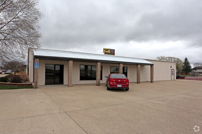
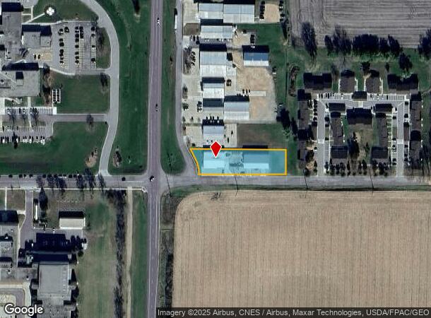
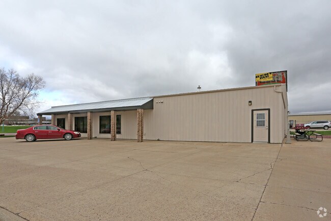
1299 Highway 15 S
Fairmont, MN
Country Side 4Th Ext.
230920020
COUNTRY SIDE 4TH EXT. LOT-001 BLOCK-001 S100
Commercialnec
Martin
2024
Minnesota
2025
1
790600
0.83 AC
5,040 SF
Other Market Areas
DEMOGRAPHICS near 1299 Highway 15 S
1 Mile
3 Mile
5 Mile
2024 Total Population
3,526
10,698
11,123
2029 Population
3,443
10,518
10,923
Pop Growth 2024-2029
(2.35%)
(1.68%)
(1.80%)
Average Age
44
43
43
2024 Total Households
1,668
4,798
4,965
HH Growth 2024-2029
(2.40%)
(1.79%)
(1.89%)
Median Household Inc
$52,868
$57,618
$58,050
Avg Household Size
2.10
2.20
2.20
2024 Avg HH Vehicles
2.00
2.00
2.00
Median Home Value
$145,243
$149,915
$152,416
Median Year Built
1966
1960
1959
Nearby Places
Map Layers
Map Styles
 Street
 Aerial
- Restaurants
- Banks
- Shops
- Fitness
- Groceries
SALE & LEASE HISTORY
LISTING DATE
SALE/LEASE

May 04, 2017
For Sale
Nearby Properties
Address
Land Use
TOTAL SIZE
Lot Size
Zoning
Address
Land Use
TOTAL SIZE
Lot Size
Zoning
128,490 SF
69.54 AC
Address
Land Use
TOTAL SIZE
Lot Size
Zoning
100,470 SF
29.50 AC
Address
Land Use
TOTAL SIZE
Lot Size
Zoning
65,633 SF
21.43 AC
Address
Land Use
TOTAL SIZE
Lot Size
Zoning
2,790 SF
9.19 AC
Address
Land Use
TOTAL SIZE
Lot Size
Zoning
96,255 SF
4.90 AC
Address
Land Use
TOTAL SIZE
Lot Size
Zoning
24,662 SF
6.71 AC
Address
Land Use
TOTAL SIZE
Lot Size
Zoning
78,080 SF
5.63 AC
Address
Land Use
TOTAL SIZE
Lot Size
Zoning
66,220 SF
5.51 AC
Address
Land Use
TOTAL SIZE
Lot Size
Zoning
7.29 AC
Address
Land Use
TOTAL SIZE
Lot Size
Zoning
6.60 AC
Address
Land Use
TOTAL SIZE
Lot Size
Zoning
24,363 SF
3.80 AC
B3
Address
Land Use
TOTAL SIZE
Lot Size
Zoning
7,895 SF
2.67 AC
Address
Land Use
TOTAL SIZE
Lot Size
Zoning
50,625 SF
4.48 AC
Address
Land Use
TOTAL SIZE
Lot Size
Zoning
5,920 SF
225.97 AC
Address
Land Use
TOTAL SIZE
Lot Size
Zoning
62,811 SF
0.28 AC
Address
Land Use
TOTAL SIZE
Lot Size
Zoning
387.81 AC
Address
Land Use
TOTAL SIZE
Lot Size
Zoning
15,868 SF
3.51 AC
B3
Address
Land Use
TOTAL SIZE
Lot Size
Zoning
18,144 SF
6.70 AC
Address
Land Use
TOTAL SIZE
Lot Size
Zoning
55,750 SF
5.27 AC
Address
Land Use
TOTAL SIZE
Lot Size
Zoning
16,668 SF
11.59 AC
I1
Address
Land Use
TOTAL SIZE
Lot Size
Zoning
6,399 SF
4.29 AC
Address
Land Use
TOTAL SIZE
Lot Size
Zoning
2,928 SF
6.54 AC
R3
Address
Land Use
TOTAL SIZE
Lot Size
Zoning
4,500 SF
8.17 AC
I2
Address
Land Use
TOTAL SIZE
Lot Size
Zoning
2,186 SF
260.50 AC
Address
Land Use
TOTAL SIZE
Lot Size
Zoning
146,683 SF
39.64 AC
Address
Land Use
TOTAL SIZE
Lot Size
Zoning
1,902 SF
309.22 AC
Address
Land Use
TOTAL SIZE
Lot Size
Zoning
16,857 SF
1.77 AC
B3
Address
Land Use
TOTAL SIZE
Lot Size
Zoning
5,250 SF
6.74 AC
Address
Land Use
TOTAL SIZE
Lot Size
Zoning
258.72 AC
Address
Land Use
TOTAL SIZE
Lot Size
Zoning
12,480 SF
1.45 AC
B3
The World's #1 Commercial Real Estate Marketplace
Connect with us
© 2025 CoStar Group
The information above has been obtained from sources believed reliable. While we do not doubt its accuracy we have not verified it and make no guarantee, warranty or representation about it. It is your responsibility to independently confirm its accuracy and completeness. Any projections, opinions, assumptions, or estimates used are for example only and do not represent the current or future performance of the property. The value of this transaction to you depends on tax and other factors which should be evaluated by your tax, financial, and legal advisors. You and your advisors should conduct a careful, independent investigation of the property to determine to your satisfaction the suitability of the property for your needs.