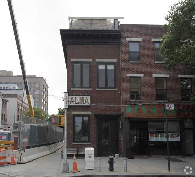
Property Record
187 Columbia St, Brooklyn, NY 11231


Save to a Folder
{{folder.Name}}
{{folder.ListingIds.length}} Properties
{{folder.ListingIds.length}} Property
Create a New Folder
Property Detail
187 Columbia St
00330-0010
DOCID-2019102100091001
Storebuilding
Kings
R6A
New York
B and X Area of moderate flood hazard, usually the area between the limits of the 100-year and 500-year floods.
10
2025
0.03 AC
2026
North Brooklyn
005100
Long Island (New York)
2,880 SF
New York-Jersey City-White Plains, NY-NJ
NEARBY LISTINGS FOR SALE OR LEASE
DEMOGRAPHICS near 187 Columbia St
1 mile
3 mile
5 mile
2025 Total Population
88,695
864,394
2,659,848
2030 Population
89,531
882,793
2,703,027
Pop Growth 2025-2030
+ 0.94%
+ 2.13%
+ 1.62%
Average Age
39
38
38
2025 Total Households
39,578
364,350
1,088,208
HH Growth 2025-2030
+ 0.56%
+ 2.33%
+ 2.03%
Median Household Inc
$156,314
$114,906
$99,054
Avg Household Size
2.10
2.20
2.30
2025 Avg HH Vehicles
.00
.00
.00
Median Home Value
$1,078,845
$1,045,458
$979,977
Median Year Built
1947
1949
1949
Nearby Places
Map Layers
Map Styles
 Street
 Aerial
Layers
 Traffic
 Biking
Places
Listings with unknown addresses are not visible on the map
- Restaurants
- Banks
- Shops
- Fitness
- Groceries
Nearby Properties
Address
Land Use
TOTAL SIZE
Lot Size
Zoning
Address
Land Use
TOTAL SIZE
Lot Size
Zoning
2,354,289 SF
3.96 AC
C6-4
Address
Land Use
TOTAL SIZE
Lot Size
Zoning
2,812,739 SF
2.10 AC
C5-3
Address
Land Use
TOTAL SIZE
Lot Size
Zoning
2.38 AC
Address
Land Use
TOTAL SIZE
Lot Size
Zoning
2,157,862 SF
2.23 AC
BPC
Address
Land Use
TOTAL SIZE
Lot Size
Zoning
1.75 AC
Address
Land Use
TOTAL SIZE
Lot Size
Zoning
2,255,659 SF
4.58 AC
BPC
Address
Land Use
TOTAL SIZE
Lot Size
Zoning
1,104,184 SF
1.12 AC
C5-5
Address
Land Use
TOTAL SIZE
Lot Size
Zoning
1,009,855 SF
3.25 AC
C6-3
Address
Land Use
TOTAL SIZE
Lot Size
Zoning
Address
Land Use
TOTAL SIZE
Lot Size
Zoning
6.42 AC
Address
Land Use
TOTAL SIZE
Lot Size
Zoning
2,233,692 SF
1.90 AC
BPC
Address
Land Use
TOTAL SIZE
Lot Size
Zoning
1,636,000 SF
1.09 AC
C6-4
Address
Land Use
TOTAL SIZE
Lot Size
Zoning
1,909,502 SF
2.37 AC
BPC
Address
Land Use
TOTAL SIZE
Lot Size
Zoning
7,058,736 SF
147.61 AC
M3-1
Address
Land Use
TOTAL SIZE
Lot Size
Zoning
802,000 SF
1.20 AC
C62A
Address
Land Use
TOTAL SIZE
Lot Size
Zoning
1,780,030 SF
5.07 AC
BPC
Address
Land Use
TOTAL SIZE
Lot Size
Zoning
1,166,710 SF
4.22 AC
C1-7
Address
Land Use
TOTAL SIZE
Lot Size
Zoning
869,038 SF
1.53 AC
M1-1
Address
Land Use
TOTAL SIZE
Lot Size
Zoning
1.04 AC
Address
Land Use
TOTAL SIZE
Lot Size
Zoning
1.87 AC
I-2
Address
Land Use
TOTAL SIZE
Lot Size
Zoning
1,617,206 SF
1.23 AC
C5-5
Address
Land Use
TOTAL SIZE
Lot Size
Zoning
92,440 SF
466.23 AC
R5
Address
Land Use
TOTAL SIZE
Lot Size
Zoning
1.84 AC
Address
Land Use
TOTAL SIZE
Lot Size
Zoning
2,210,200 SF
2.58 AC
C5-5
Address
Land Use
TOTAL SIZE
Lot Size
Zoning
1,362,190 SF
C5-5
Address
Land Use
TOTAL SIZE
Lot Size
Zoning
2.21 AC
Address
Land Use
TOTAL SIZE
Lot Size
Zoning
1,653,794 SF
3.15 AC
C6-4
Address
Land Use
TOTAL SIZE
Lot Size
Zoning
0.66 AC
Address
Land Use
TOTAL SIZE
Lot Size
Zoning
932,587 SF
1.23 AC
C5-3
Address
Land Use
TOTAL SIZE
Lot Size
Zoning
972,820 SF
1.98 AC
M1-6
The World's #1 Commercial Real Estate Marketplace
Connect with us
© 2026 CoStar Group
The information above has been obtained from sources believed reliable. While we do not doubt its accuracy we have not verified it and make no guarantee, warranty or representation about it. It is your responsibility to independently confirm its accuracy and completeness. Any projections, opinions, assumptions, or estimates used are for example only and do not represent the current or future performance of the property. The value of this transaction to you depends on tax and other factors which should be evaluated by your tax, financial, and legal advisors. You and your advisors should conduct a careful, independent investigation of the property to determine to your satisfaction the suitability of the property for your needs.