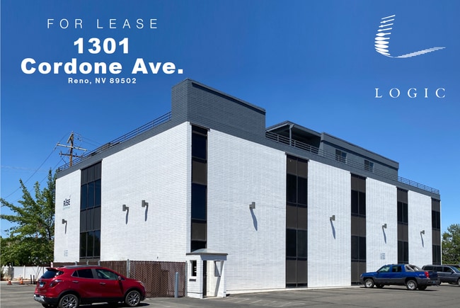
Property Record
1301 Cordone Ave, Reno, NV 89502
Current Lease Availabilities
NEARBY LISTINGS FOR SALE OR LEASE
Property Detail
1301 Cordone Ave
013-391-09
_Unspecified
Commercialnec
FRAC NE4 SE4 SEC 13 TWP 19N RGE 19E
X
Washoe
32031C3043G
Nevada
2025
0.67 AC
2026
Central/Airport
000201
Reno/Sparks
25,543 SF
Reno, NV
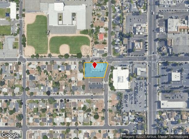
DEMOGRAPHICS near 1301 Cordone Ave
1 mile
3 mile
5 mile
2024 Total Population
17,865
126,076
246,506
2029 Population
18,857
132,454
259,916
Pop Growth 2024-2029
+ 5.55%
+ 5.06%
+ 5.44%
Average Age
38
39
39
2024 Total Households
7,381
54,127
102,522
HH Growth 2024-2029
+ 5.69%
+ 5.15%
+ 5.63%
Median Household Inc
$45,819
$49,013
$61,267
Avg Household Size
2.20
2.20
2.30
2024 Avg HH Vehicles
1.00
2.00
2.00
Median Home Value
$312,388
$405,307
$423,903
Median Year Built
1970
1975
1980
Nearby Places
Map Layers
Map Styles
 Street
 Aerial
Transit
 Traffic
 Biking
Places
Listings with unknown addresses are not visible on the map
- Restaurants
- Banks
- Shops
- Fitness
- Groceries
PUBLIC TRANSPORTATION
COMMUTER RAIL
Drive
Walk
Distance
5 min
2.0 mi
AIRPORT
Reno/Tahoe International
Drive
Walk
Distance
Reno/Tahoe International
22 min
4.4 mi
Nearby Properties
Address
Land Use
TOTAL SIZE
Lot Size
Zoning
Address
Land Use
TOTAL SIZE
Lot Size
Zoning
120.45 AC
PF
Address
Land Use
TOTAL SIZE
Lot Size
Zoning
2,041,608 SF
28.47 AC
MU
Address
Land Use
TOTAL SIZE
Lot Size
Zoning
1,638,272 SF
17.11 AC
MU
Address
Land Use
TOTAL SIZE
Lot Size
Zoning
762,384 SF
1,131.28 AC
MA
Address
Land Use
TOTAL SIZE
Lot Size
Zoning
1,103,124 SF
138.61 AC
MU
Address
Land Use
TOTAL SIZE
Lot Size
Zoning
799,762 SF
13.30 AC
MU
Address
Land Use
TOTAL SIZE
Lot Size
Zoning
1,865,345 SF
2.75 AC
MD-ED
Address
Land Use
TOTAL SIZE
Lot Size
Zoning
1.47 AC
MD-UD
Address
Land Use
TOTAL SIZE
Lot Size
Zoning
1,048,514 SF
1.30 AC
MU
Address
Land Use
TOTAL SIZE
Lot Size
Zoning
759,161 SF
37.37 AC
MU
Address
Land Use
TOTAL SIZE
Lot Size
Zoning
991,800 SF
51.03 AC
PD
Address
Land Use
TOTAL SIZE
Lot Size
Zoning
893,055 SF
52.71 AC
MA
Address
Land Use
TOTAL SIZE
Lot Size
Zoning
507,606 SF
3.42 AC
MU
Address
Land Use
TOTAL SIZE
Lot Size
Zoning
497,928 SF
3.52 AC
MU
Address
Land Use
TOTAL SIZE
Lot Size
Zoning
645,699 SF
4.53 AC
MU
Address
Land Use
TOTAL SIZE
Lot Size
Zoning
501,541 SF
2.89 AC
MD-ED
Address
Land Use
TOTAL SIZE
Lot Size
Zoning
292,461 SF
1.22 AC
MU
Address
Land Use
TOTAL SIZE
Lot Size
Zoning
296,048 SF
93.65 AC
PF
Address
Land Use
TOTAL SIZE
Lot Size
Zoning
500,079 SF
45.66 AC
SPD
Address
Land Use
TOTAL SIZE
Lot Size
Zoning
460,367 SF
1.52 AC
MD-ED
Address
Land Use
TOTAL SIZE
Lot Size
Zoning
189,861 SF
1.69 AC
MD-NWQ
Address
Land Use
TOTAL SIZE
Lot Size
Zoning
232,156 SF
1.76 AC
MU
Address
Land Use
TOTAL SIZE
Lot Size
Zoning
460,688 SF
62.55 AC
PF
Address
Land Use
TOTAL SIZE
Lot Size
Zoning
234,478 SF
2.93 AC
MD-ED
Address
Land Use
TOTAL SIZE
Lot Size
Zoning
342,947 SF
8.95 AC
MF30
Address
Land Use
TOTAL SIZE
Lot Size
Zoning
587,380 SF
2.59 AC
MD-ED
Address
Land Use
TOTAL SIZE
Lot Size
Zoning
257,400 SF
2.71 AC
MD-ED
Address
Land Use
TOTAL SIZE
Lot Size
Zoning
434,002 SF
7.64 AC
MD-NWQ
Address
Land Use
TOTAL SIZE
Lot Size
Zoning
194,000 SF
2.24 AC
MD-RD
Address
Land Use
TOTAL SIZE
Lot Size
Zoning
283,243 SF
2.02 AC
MD-UD
The World's #1 Commercial Real Estate Marketplace
Connect with us
© 2026 CoStar Group
The information above has been obtained from sources believed reliable. While we do not doubt its accuracy we have not verified it and make no guarantee, warranty or representation about it. It is your responsibility to independently confirm its accuracy and completeness. Any projections, opinions, assumptions, or estimates used are for example only and do not represent the current or future performance of the property. The value of this transaction to you depends on tax and other factors which should be evaluated by your tax, financial, and legal advisors. You and your advisors should conduct a careful, independent investigation of the property to determine to your satisfaction the suitability of the property for your needs.