Property Record
1303 Rilling Rd, San Antonio, TX 78214
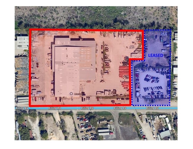


Current Lease Availabilities
NEARBY LISTINGS FOR SALE OR LEASE
Property Detail
1303 Rilling Rd
San Antonio-New Braunfels, TX
Conv A/S Code
11169-000-0260
NCB 11169 BLK LOT 26
Warehouse
Bexar
X
Texas
48029C0580G
26
2024
5.72 AC
2025
South
192200
San Antonio
40,536 SF
DEMOGRAPHICS near 1303 Rilling Rd
1 Mile
3 Mile
5 Mile
2024 Total Population
5,498
62,260
181,489
2029 Population
5,843
66,719
193,487
Pop Growth 2024-2029
+ 6.28%
+ 7.16%
+ 6.61%
Average Age
36
36
37
2024 Total Households
1,736
20,926
61,430
HH Growth 2024-2029
+ 6.34%
+ 7.26%
+ 6.75%
Median Household Inc
$55,892
$48,333
$46,378
Avg Household Size
3.10
2.90
2.90
2024 Avg HH Vehicles
2.00
2.00
2.00
Median Home Value
$132,744
$146,423
$135,804
Median Year Built
1984
1978
1968
Nearby Places
Map Layers
Map Styles
 Street
 Aerial
- Restaurants
- Banks
- Shops
- Fitness
- Groceries
PUBLIC TRANSPORTATION
COMMUTER RAIL
DRIVE
WALK
Distance
14 min
7.6 mi
AIRPORT
San Antonio International
DRIVE
WALK
Distance
San Antonio International
23 min
15.4 mi
Nearby Properties
Address
Land Use
TOTAL SIZE
Lot Size
Zoning
Address
Land Use
TOTAL SIZE
Lot Size
Zoning
32,800 SF
198.68 AC
Address
Land Use
TOTAL SIZE
Lot Size
Zoning
639,848 SF
85.65 AC
Address
Land Use
TOTAL SIZE
Lot Size
Zoning
220,079 SF
28.12 AC
Address
Land Use
TOTAL SIZE
Lot Size
Zoning
250,400 SF
20.55 AC
Address
Land Use
TOTAL SIZE
Lot Size
Zoning
61,085 SF
16.73 AC
Address
Land Use
TOTAL SIZE
Lot Size
Zoning
158,546 SF
6.45 AC
Address
Land Use
TOTAL SIZE
Lot Size
Zoning
211,200 SF
7.49 AC
Address
Land Use
TOTAL SIZE
Lot Size
Zoning
12,504,292 SF
32.18 AC
Address
Land Use
TOTAL SIZE
Lot Size
Zoning
162,632 SF
11.06 AC
Address
Land Use
TOTAL SIZE
Lot Size
Zoning
174,316 SF
15.38 AC
Address
Land Use
TOTAL SIZE
Lot Size
Zoning
353,148 SF
14.10 AC
Address
Land Use
TOTAL SIZE
Lot Size
Zoning
148,525 SF
30.72 AC
Address
Land Use
TOTAL SIZE
Lot Size
Zoning
163.70 AC
Address
Land Use
TOTAL SIZE
Lot Size
Zoning
146,010 SF
9.01 AC
Address
Land Use
TOTAL SIZE
Lot Size
Zoning
372,078 SF
10.95 AC
Address
Land Use
TOTAL SIZE
Lot Size
Zoning
211,365 SF
11.65 AC
Address
Land Use
TOTAL SIZE
Lot Size
Zoning
71,607 SF
10.46 AC
Address
Land Use
TOTAL SIZE
Lot Size
Zoning
148,672 SF
11.84 AC
Address
Land Use
TOTAL SIZE
Lot Size
Zoning
79,740 SF
0.60 AC
Address
Land Use
TOTAL SIZE
Lot Size
Zoning
42.31 AC
Address
Land Use
TOTAL SIZE
Lot Size
Zoning
217,483 SF
21.94 AC
Address
Land Use
TOTAL SIZE
Lot Size
Zoning
38,671 SF
5.20 AC
Address
Land Use
TOTAL SIZE
Lot Size
Zoning
Address
Land Use
TOTAL SIZE
Lot Size
Zoning
203,232 SF
24.20 AC
Address
Land Use
TOTAL SIZE
Lot Size
Zoning
244,072 SF
13.97 AC
Address
Land Use
TOTAL SIZE
Lot Size
Zoning
89,949 SF
7.14 AC
Address
Land Use
TOTAL SIZE
Lot Size
Zoning
99,361 SF
9.93 AC
Address
Land Use
TOTAL SIZE
Lot Size
Zoning
154,556 SF
7.52 AC
Address
Land Use
TOTAL SIZE
Lot Size
Zoning
225,994 SF
12.25 AC
Address
Land Use
TOTAL SIZE
Lot Size
Zoning
144,137 SF
10.44 AC
The World's #1 Commercial Real Estate Marketplace
Connect with us
© 2025 CoStar Group
The information above has been obtained from sources believed reliable. While we do not doubt its accuracy we have not verified it and make no guarantee, warranty or representation about it. It is your responsibility to independently confirm its accuracy and completeness. Any projections, opinions, assumptions, or estimates used are for example only and do not represent the current or future performance of the property. The value of this transaction to you depends on tax and other factors which should be evaluated by your tax, financial, and legal advisors. You and your advisors should conduct a careful, independent investigation of the property to determine to your satisfaction the suitability of the property for your needs.