Property Record
1308 Highway 41 N, Milner, GA 30257

NEARBY LISTINGS FOR SALE OR LEASE
-
-
View all Milner listings for sale on LoopNet.com
Property Detail
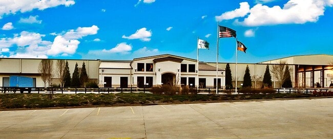
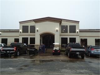
1308 Highway 41 N
006-064
BUILDINGS & LAND - 1308 HWY 41 N
Publicstorage
Lamar
X
Georgia
13255C0215E
31.65 AC
2024
Lamar County
2025
Atlanta
970100
Atlanta-Sandy Springs-Roswell, GA
9,552 SF
DEMOGRAPHICS near 1308 Highway 41 N
1 Mile
3 Mile
5 Mile
2024 Total Population
480
3,299
11,887
2029 Population
566
3,872
13,518
Pop Growth 2024-2029
+ 17.92%
+ 17.37%
+ 13.72%
Average Age
43
42
41
2024 Total Households
179
1,229
4,424
HH Growth 2024-2029
+ 17.88%
+ 17.25%
+ 13.63%
Median Household Inc
$78,409
$72,685
$70,338
Avg Household Size
2.60
2.60
2.60
2024 Avg HH Vehicles
2.00
2.00
2.00
Median Home Value
$240,277
$236,240
$224,741
Median Year Built
1990
1993
1992
Nearby Places
Map Layers
Map Styles
 Street
 Aerial
- Restaurants
- Banks
- Shops
- Fitness
- Groceries
SALE & LEASE HISTORY
LISTING DATE
SALE/LEASE

Nov 09, 2022
For Sale
Nearby Properties
Address
Land Use
TOTAL SIZE
Lot Size
Zoning
Address
Land Use
TOTAL SIZE
Lot Size
Zoning
37,060 SF
18.80 AC
RESIDENTIA
Address
Land Use
TOTAL SIZE
Lot Size
Zoning
20,256 SF
38.65 AC
024
Address
Land Use
TOTAL SIZE
Lot Size
Zoning
8,370 SF
12.50 AC
RESIDENTIA
Address
Land Use
TOTAL SIZE
Lot Size
Zoning
27,680 SF
15 AC
RESIDENTIA
Address
Land Use
TOTAL SIZE
Lot Size
Zoning
60,000 SF
10.19 AC
RESIDENTIA
Address
Land Use
TOTAL SIZE
Lot Size
Zoning
10,928 SF
4.59 AC
001
Address
Land Use
TOTAL SIZE
Lot Size
Zoning
720 SF
176.96 AC
RESIDENTIA
Address
Land Use
TOTAL SIZE
Lot Size
Zoning
4,000 SF
48.01 AC
002
Address
Land Use
TOTAL SIZE
Lot Size
Zoning
7,601 SF
6.10 AC
RESIDENTIA
Address
Land Use
TOTAL SIZE
Lot Size
Zoning
1,500 SF
51.51 AC
004
Address
Land Use
TOTAL SIZE
Lot Size
Zoning
52.51 AC
004
Address
Land Use
TOTAL SIZE
Lot Size
Zoning
6,084 SF
2 AC
Address
Land Use
TOTAL SIZE
Lot Size
Zoning
9,146 SF
0.97 AC
C-2
Address
Land Use
TOTAL SIZE
Lot Size
Zoning
21,040 SF
12.37 AC
RESIDENTIA
Address
Land Use
TOTAL SIZE
Lot Size
Zoning
14,494 SF
61.22 AC
004
Address
Land Use
TOTAL SIZE
Lot Size
Zoning
5,280 SF
2.38 AC
C-2
Address
Land Use
TOTAL SIZE
Lot Size
Zoning
7,327 SF
1.16 AC
C2
Address
Land Use
TOTAL SIZE
Lot Size
Zoning
196.20 AC
004
Address
Land Use
TOTAL SIZE
Lot Size
Zoning
3,533 SF
10 AC
Address
Land Use
TOTAL SIZE
Lot Size
Zoning
5,363 SF
12.62 AC
001
Address
Land Use
TOTAL SIZE
Lot Size
Zoning
4,640 SF
2.07 AC
002
Address
Land Use
TOTAL SIZE
Lot Size
Zoning
118.45 AC
004
Address
Land Use
TOTAL SIZE
Lot Size
Zoning
144.26 AC
RESIDENTIA
Address
Land Use
TOTAL SIZE
Lot Size
Zoning
4,240 SF
0.38 AC
001
Address
Land Use
TOTAL SIZE
Lot Size
Zoning
110.06 AC
RESIDENTIA
Address
Land Use
TOTAL SIZE
Lot Size
Zoning
132.61 AC
004
Address
Land Use
TOTAL SIZE
Lot Size
Zoning
476 SF
6 AC
M-1
Address
Land Use
TOTAL SIZE
Lot Size
Zoning
2,400 SF
5.62 AC
Address
Land Use
TOTAL SIZE
Lot Size
Zoning
105.96 AC
RESIDENTIA
The World's #1 Commercial Real Estate Marketplace
Connect with us
© 2025 CoStar Group
The information above has been obtained from sources believed reliable. While we do not doubt its accuracy we have not verified it and make no guarantee, warranty or representation about it. It is your responsibility to independently confirm its accuracy and completeness. Any projections, opinions, assumptions, or estimates used are for example only and do not represent the current or future performance of the property. The value of this transaction to you depends on tax and other factors which should be evaluated by your tax, financial, and legal advisors. You and your advisors should conduct a careful, independent investigation of the property to determine to your satisfaction the suitability of the property for your needs.