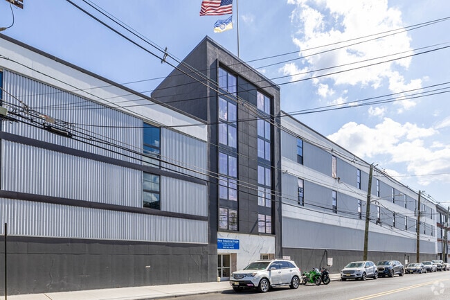
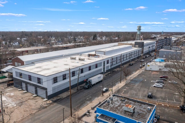
Property Record
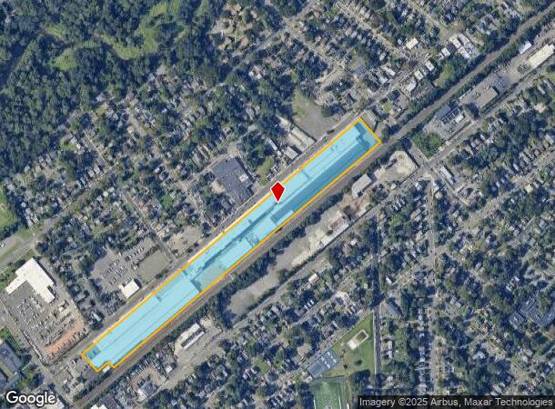
1309 W Front St, Plainfield, NJ 07063
Current Lease Availabilities
NEARBY LISTINGS FOR SALE OR LEASE
Property Detail
1309 W Front St
12-00210-0000-00002
Union
Commercialnec
New Jersey
X
2
34023C0027F
10.93 AC
2024
Route 78/22 East
2025
Northern New Jersey
039502
Newark, NJ-PA
DEMOGRAPHICS near 1309 W Front St
1 Mile
3 Mile
5 Mile
2024 Total Population
20,351
133,929
254,429
2029 Population
19,911
132,359
252,287
Pop Growth 2024-2029
(2.16%)
(1.17%)
(0.84%)
Average Age
37
39
39
2024 Total Households
5,785
43,452
83,496
HH Growth 2024-2029
(2.20%)
(1.14%)
(0.86%)
Median Household Inc
$81,916
$87,624
$108,869
Avg Household Size
3.40
3.00
2.90
2024 Avg HH Vehicles
2.00
2.00
2.00
Median Home Value
$330,962
$368,134
$431,349
Median Year Built
1949
1959
1964
Nearby Places
- Restaurants
- Banks
- Shops
- Fitness
- Groceries
PUBLIC TRANSPORTATION
COMMUTER RAIL
Dunellen (Raritan Valley Line - NJ Transit Commuter Rail (NJ Transit))
DRIVE
WALK
Distance
Dunellen (Raritan Valley Line - NJ Transit Commuter Rail (NJ Transit))
3 min
20 min
1.1 mi
Plainfield (Raritan Valley Line - NJ Transit Commuter Rail (NJ Transit))
DRIVE
WALK
Distance
Plainfield (Raritan Valley Line - NJ Transit Commuter Rail (NJ Transit))
5 min
2.0 mi
AIRPORT
Newark Liberty International
DRIVE
WALK
Distance
Newark Liberty International
33 min
23.4 mi
Trenton Mercer
DRIVE
WALK
Distance
Trenton Mercer
59 min
38.7 mi
Freight Ports
New York Container Terminal
DRIVE
WALK
Distance
New York Container Terminal
36 min
19.3 mi
Nearby Properties
Address
Land Use
TOTAL SIZE
Lot Size
Zoning
Address
Land Use
TOTAL SIZE
Lot Size
Zoning
24.62 AC
R20
Address
Land Use
TOTAL SIZE
Lot Size
Zoning
17.01 AC
RM
Address
Land Use
TOTAL SIZE
Lot Size
Zoning
20.08 AC
RML1
Address
Land Use
TOTAL SIZE
Lot Size
Zoning
17.64 AC
R10A
Address
Land Use
TOTAL SIZE
Lot Size
Zoning
27.51 AC
RM
Address
Land Use
TOTAL SIZE
Lot Size
Zoning
38.04 AC
RM
Address
Land Use
TOTAL SIZE
Lot Size
Zoning
12.57 AC
RM
Address
Land Use
TOTAL SIZE
Lot Size
Zoning
10.09 AC
Address
Land Use
TOTAL SIZE
Lot Size
Zoning
27.70 AC
Address
Land Use
TOTAL SIZE
Lot Size
Zoning
16.21 AC
RM
Address
Land Use
TOTAL SIZE
Lot Size
Zoning
63.87 AC
LI5
Address
Land Use
TOTAL SIZE
Lot Size
Zoning
25.74 AC
LI5
Address
Land Use
TOTAL SIZE
Lot Size
Zoning
233,217 SF
36.91 AC
LI5
Address
Land Use
TOTAL SIZE
Lot Size
Zoning
11.83 AC
RM
Address
Land Use
TOTAL SIZE
Lot Size
Zoning
1,388 SF
3.99 AC
LI5
Address
Land Use
TOTAL SIZE
Lot Size
Zoning
96,102 SF
23.60 AC
ER
Address
Land Use
TOTAL SIZE
Lot Size
Zoning
10.50 AC
RM
Address
Land Use
TOTAL SIZE
Lot Size
Zoning
15.79 AC
H-D
Address
Land Use
TOTAL SIZE
Lot Size
Zoning
9.05 AC
RM
Address
Land Use
TOTAL SIZE
Lot Size
Zoning
15 AC
R75
Address
Land Use
TOTAL SIZE
Lot Size
Zoning
7.91 AC
RM
Address
Land Use
TOTAL SIZE
Lot Size
Zoning
27 AC
MD
Address
Land Use
TOTAL SIZE
Lot Size
Zoning
9.38 AC
RM
Address
Land Use
TOTAL SIZE
Lot Size
Zoning
78,153 SF
11.30 AC
SC
Address
Land Use
TOTAL SIZE
Lot Size
Zoning
168,032 SF
14.75 AC
LI5
Address
Land Use
TOTAL SIZE
Lot Size
Zoning
19.84 AC
Address
Land Use
TOTAL SIZE
Lot Size
Zoning
9.85 AC
10A
Address
Land Use
TOTAL SIZE
Lot Size
Zoning
16.97 AC
Address
Land Use
TOTAL SIZE
Lot Size
Zoning
30.80 AC
R10
Address
Land Use
TOTAL SIZE
Lot Size
Zoning
2,800 SF
16.73 AC
R20V
The World's #1 Commercial Real Estate Marketplace
Connect with us
© 2025 CoStar Group
The information above has been obtained from sources believed reliable. While we do not doubt its accuracy we have not verified it and make no guarantee, warranty or representation about it. It is your responsibility to independently confirm its accuracy and completeness. Any projections, opinions, assumptions, or estimates used are for example only and do not represent the current or future performance of the property. The value of this transaction to you depends on tax and other factors which should be evaluated by your tax, financial, and legal advisors. You and your advisors should conduct a careful, independent investigation of the property to determine to your satisfaction the suitability of the property for your needs.