Property Record
131 Taaffe Pl, Brooklyn, NY 11205
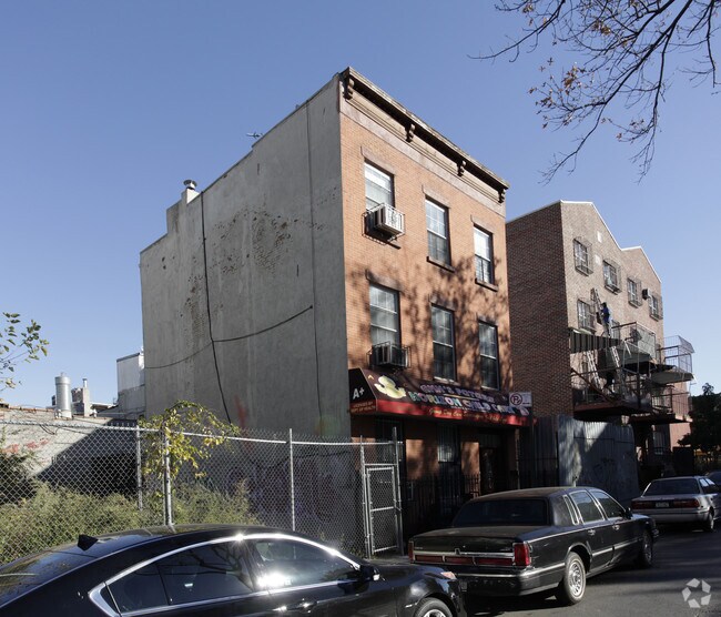

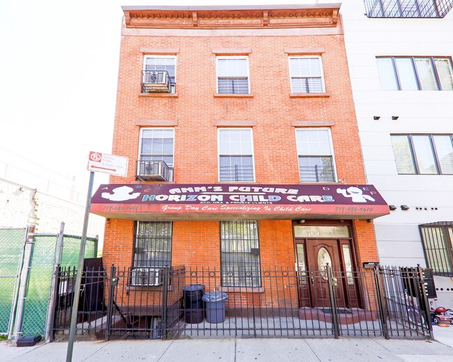
Property Detail
131 Taaffe Pl
01897-0005
DOCID-2020012100305001
Religious
Kings
M1-1
New York
B and X Area of moderate flood hazard, usually the area between the limits of the 100-year and 500-year floods.
5
2024
0.05 AC
2025
North Brooklyn
123700
Long Island (New York)
4,722 SF
New York-Jersey City-White Plains, NY-NJ
NEARBY LISTINGS FOR SALE OR LEASE
DEMOGRAPHICS near 131 Taaffe Pl
1 mile
3 mile
5 mile
2025 Total Population
197,369
1,380,574
2,997,444
2030 Population
199,562
1,399,912
3,026,541
Pop Growth 2025-2030
+ 1.11%
+ 1.40%
+ 0.97%
Average Age
34
38
39
2025 Total Households
68,751
570,091
1,224,710
HH Growth 2025-2030
+ 0.71%
+ 1.35%
+ 1.44%
Median Household Inc
$73,870
$96,225
$96,705
Avg Household Size
2.70
2.30
2.30
2025 Avg HH Vehicles
.00
.00
.00
Median Home Value
$939,777
$1,037,183
$942,810
Median Year Built
1954
1948
1949
Nearby Places
Map Layers
Map Styles
 Street
 Aerial
Transit
 Traffic
 Biking
Places
Listings with unknown addresses are not visible on the map
- Restaurants
- Banks
- Shops
- Fitness
- Groceries
PUBLIC TRANSPORTATION
TRANSIT/SUBWAY
Classon Avenue (G - New York MTA Subway (The Subway))
Drive
Walk
Distance
Classon Avenue (G - New York MTA Subway (The Subway))
3 min
8 min
0.4 mi
Bedford-Nostrand Avenues (G - New York MTA Subway (The Subway))
Drive
Walk
Distance
Bedford-Nostrand Avenues (G - New York MTA Subway (The Subway))
3 min
13 min
0.7 mi
Myrtle-Willoughby Avenues (G - New York MTA Subway (The Subway))
Drive
Walk
Distance
Myrtle-Willoughby Avenues (G - New York MTA Subway (The Subway))
4 min
13 min
0.7 mi
Clinton-Washington Avenues (G Line) (G - New York MTA Subway (The Subway))
Drive
Walk
Distance
Clinton-Washington Avenues (G Line) (G - New York MTA Subway (The Subway))
3 min
15 min
0.8 mi
Flushing Avenue (G Line) (G - New York MTA Subway (The Subway))
Drive
Walk
Distance
Flushing Avenue (G Line) (G - New York MTA Subway (The Subway))
3 min
17 min
0.9 mi
COMMUTER RAIL
Nostrand Avenue Station (Far Rockaway Branch - Long Island Rail Road, Hempstead Branch - Long Island Rail Road, Long Beach Branch - Long Island Rail Road, West Hempstead Branch - Long Island Rail Road)
Drive
Walk
Distance
Nostrand Avenue Station (Far Rockaway Branch - Long Island Rail Road, Hempstead Branch - Long Island Rail Road, Long Beach Branch - Long Island Rail Road, West Hempstead Branch - Long Island Rail Road)
6 min
1.9 mi
Drive
Walk
Distance
6 min
2.1 mi
AIRPORT
LaGuardia
Drive
Walk
Distance
LaGuardia
16 min
8.4 mi
Newark Liberty International
Drive
Walk
Distance
Newark Liberty International
26 min
15.4 mi
John F Kennedy International
Drive
Walk
Distance
John F Kennedy International
26 min
16.6 mi
Freight Ports
NY - Red Hook Container Terminal
Drive
Walk
Distance
NY - Red Hook Container Terminal
8 min
3.7 mi
SALE & LEASE HISTORY
LISTING DATE
SALE/LEASE

Oct 23, 2018
For Sale
Mar 04, 2019
For Sale
Jul 31, 2018
For Sale
Nearby Properties
Address
Land Use
TOTAL SIZE
Lot Size
Zoning
Address
Land Use
TOTAL SIZE
Lot Size
Zoning
8,462,176 SF
61.41 AC
R7-2
Address
Land Use
TOTAL SIZE
Lot Size
Zoning
2,812,739 SF
2.10 AC
C5-3
Address
Land Use
TOTAL SIZE
Lot Size
Zoning
1,104,505 SF
2.32 AC
C4-7
Address
Land Use
TOTAL SIZE
Lot Size
Zoning
940,000 SF
1.44 AC
C6-2
Address
Land Use
TOTAL SIZE
Lot Size
Zoning
7,058,736 SF
147.61 AC
M3-1
Address
Land Use
TOTAL SIZE
Lot Size
Zoning
869,038 SF
1.53 AC
M1-1
Address
Land Use
TOTAL SIZE
Lot Size
Zoning
1,260,362 SF
4.32 AC
C1-7
Address
Land Use
TOTAL SIZE
Lot Size
Zoning
802,000 SF
1.20 AC
C62A
Address
Land Use
TOTAL SIZE
Lot Size
Zoning
3,122,165 SF
19.02 AC
R7-2
Address
Land Use
TOTAL SIZE
Lot Size
Zoning
2,210,200 SF
2.58 AC
C5-5
Address
Land Use
TOTAL SIZE
Lot Size
Zoning
1,362,190 SF
C5-5
Address
Land Use
TOTAL SIZE
Lot Size
Zoning
1,653,794 SF
3.15 AC
C6-4
Address
Land Use
TOTAL SIZE
Lot Size
Zoning
932,587 SF
1.23 AC
C5-3
Address
Land Use
TOTAL SIZE
Lot Size
Zoning
1,499,568 SF
1.66 AC
C5-5
Address
Land Use
TOTAL SIZE
Lot Size
Zoning
1,617,206 SF
1.23 AC
C5-5
Address
Land Use
TOTAL SIZE
Lot Size
Zoning
2,542,066 SF
174.49 AC
R3-2
Address
Land Use
TOTAL SIZE
Lot Size
Zoning
1,092,665 SF
1.06 AC
C62A
Address
Land Use
TOTAL SIZE
Lot Size
Zoning
1,503,150 SF
20.47 AC
R5
Address
Land Use
TOTAL SIZE
Lot Size
Zoning
1,075,808 SF
1.12 AC
C5-5
Address
Land Use
TOTAL SIZE
Lot Size
Zoning
1,141,276 SF
1.21 AC
C5-5
Address
Land Use
TOTAL SIZE
Lot Size
Zoning
393.54 AC
PARK
Address
Land Use
TOTAL SIZE
Lot Size
Zoning
1,289,243 SF
1.14 AC
C5-5
Address
Land Use
TOTAL SIZE
Lot Size
Zoning
2,948,300 SF
27.71 AC
R7-2
Address
Land Use
TOTAL SIZE
Lot Size
Zoning
577,381 SF
3.19 AC
R6
Address
Land Use
TOTAL SIZE
Lot Size
Zoning
890,142 SF
2.22 AC
R7-1
Address
Land Use
TOTAL SIZE
Lot Size
Zoning
1,079,361 SF
1.07 AC
C5-3
Address
Land Use
TOTAL SIZE
Lot Size
Zoning
385,831 SF
0.83 AC
C6-3
Address
Land Use
TOTAL SIZE
Lot Size
Zoning
943,802 SF
0.97 AC
C6-9
Address
Land Use
TOTAL SIZE
Lot Size
Zoning
1,258,851 SF
2.20 AC
C6-4
Address
Land Use
TOTAL SIZE
Lot Size
Zoning
1,154,357 SF
1.73 AC
C5-3
The World's #1 Commercial Real Estate Marketplace
Connect with us
© 2026 CoStar Group
The information above has been obtained from sources believed reliable. While we do not doubt its accuracy we have not verified it and make no guarantee, warranty or representation about it. It is your responsibility to independently confirm its accuracy and completeness. Any projections, opinions, assumptions, or estimates used are for example only and do not represent the current or future performance of the property. The value of this transaction to you depends on tax and other factors which should be evaluated by your tax, financial, and legal advisors. You and your advisors should conduct a careful, independent investigation of the property to determine to your satisfaction the suitability of the property for your needs.