Property Record
1311 Meade St, Flatwoods, KY 41139
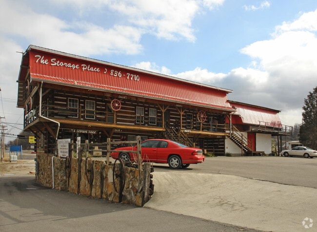

Property Detail
1311 Meade St
Huntington-Ashland, WV-KY-OH
CLANCY ADD LT 180-183
182-30-01-053.00
Greenup
Publicstorage
Kentucky
2025
180-183
2025
0.25 AC
040201
Greenup County
3,002 SF
Huntington/Ashland
NEARBY LISTINGS FOR SALE OR LEASE
DEMOGRAPHICS near 1311 Meade St
1 mile
3 mile
5 mile
2025 Total Population
3,289
25,671
39,421
2030 Population
3,243
25,044
38,542
Pop Growth 2025-2030
(1.40%)
(2.44%)
(2.23%)
Average Age
43
43
43
2025 Total Households
1,340
10,666
16,173
HH Growth 2025-2030
(1.42%)
(2.48%)
(2.24%)
Median Household Inc
$55,408
$53,728
$54,963
Avg Household Size
2.30
2.30
2.30
2025 Avg HH Vehicles
2.00
2.00
2.00
Median Home Value
$133,186
$132,825
$131,598
Median Year Built
1966
1965
1968
Nearby Places
Map Layers
Map Styles
 Street
 Aerial
Layers
 Traffic
 Biking
Places
Listings with unknown addresses are not visible on the map
- Restaurants
- Banks
- Shops
- Fitness
- Groceries
PUBLIC TRANSPORTATION
COMMUTER RAIL
Ashland Amtrak Station (Cardinal - Amtrak)
Drive
Walk
Distance
Ashland Amtrak Station (Cardinal - Amtrak)
9 min
5.9 mi
AIRPORT
Tri-State/Milton J Ferguson Field
Drive
Walk
Distance
Tri-State/Milton J Ferguson Field
30 min
17.6 mi
Freight Ports
Port of Toledo
Drive
Walk
Distance
Port of Toledo
332 min
254.5 mi
SALE & LEASE HISTORY
LISTING DATE
SALE/LEASE

Oct 23, 2025
For Sale
Nearby Properties
Address
Land Use
TOTAL SIZE
Lot Size
Zoning
Address
Land Use
TOTAL SIZE
Lot Size
Zoning
Address
Land Use
TOTAL SIZE
Lot Size
Zoning
Address
Land Use
TOTAL SIZE
Lot Size
Zoning
11.95 AC
Address
Land Use
TOTAL SIZE
Lot Size
Zoning
12.54 AC
Address
Land Use
TOTAL SIZE
Lot Size
Zoning
Address
Land Use
TOTAL SIZE
Lot Size
Zoning
40.94 AC
Address
Land Use
TOTAL SIZE
Lot Size
Zoning
Address
Land Use
TOTAL SIZE
Lot Size
Zoning
Address
Land Use
TOTAL SIZE
Lot Size
Zoning
3.86 AC
Address
Land Use
TOTAL SIZE
Lot Size
Zoning
19.91 AC
Address
Land Use
TOTAL SIZE
Lot Size
Zoning
1,424 SF
6.46 AC
Address
Land Use
TOTAL SIZE
Lot Size
Zoning
Address
Land Use
TOTAL SIZE
Lot Size
Zoning
139,148 SF
Address
Land Use
TOTAL SIZE
Lot Size
Zoning
Address
Land Use
TOTAL SIZE
Lot Size
Zoning
35,014 SF
3.81 AC
Address
Land Use
TOTAL SIZE
Lot Size
Zoning
9.43 AC
Address
Land Use
TOTAL SIZE
Lot Size
Zoning
30,250 SF
8.29 AC
Address
Land Use
TOTAL SIZE
Lot Size
Zoning
75,820 SF
1.71 AC
Address
Land Use
TOTAL SIZE
Lot Size
Zoning
1,440 SF
1.38 AC
Address
Land Use
TOTAL SIZE
Lot Size
Zoning
9.49 AC
Address
Land Use
TOTAL SIZE
Lot Size
Zoning
47,557 SF
1.69 AC
Address
Land Use
TOTAL SIZE
Lot Size
Zoning
135,431 SF
9.19 AC
Address
Land Use
TOTAL SIZE
Lot Size
Zoning
9,300 SF
7.65 AC
Address
Land Use
TOTAL SIZE
Lot Size
Zoning
Address
Land Use
TOTAL SIZE
Lot Size
Zoning
Address
Land Use
TOTAL SIZE
Lot Size
Zoning
5,472 SF
4.94 AC
Address
Land Use
TOTAL SIZE
Lot Size
Zoning
5.14 AC
Address
Land Use
TOTAL SIZE
Lot Size
Zoning
Address
Land Use
TOTAL SIZE
Lot Size
Zoning
47,253 SF
5 AC
Address
Land Use
TOTAL SIZE
Lot Size
Zoning
The World's #1 Commercial Real Estate Marketplace
Connect with us
© 2026 CoStar Group
The information above has been obtained from sources believed reliable. While we do not doubt its accuracy we have not verified it and make no guarantee, warranty or representation about it. It is your responsibility to independently confirm its accuracy and completeness. Any projections, opinions, assumptions, or estimates used are for example only and do not represent the current or future performance of the property. The value of this transaction to you depends on tax and other factors which should be evaluated by your tax, financial, and legal advisors. You and your advisors should conduct a careful, independent investigation of the property to determine to your satisfaction the suitability of the property for your needs.