Property Record
1315 E Elmdale Ct, Milwaukee, WI 53211
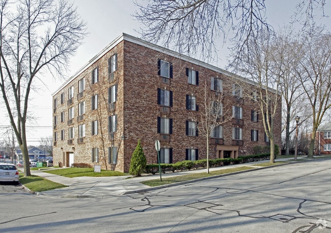

Property Detail
1315 E Elmdale Ct
Milwaukee-Waukesha, WI
ARDMORE TERRACE SE 1/4 4-7-22 E. LOTS 13 14 & 15 BLK 2
240-0013-000
MILWAUKEE
Commercialnec
Wisconsin
B and X Area of moderate flood hazard, usually the area between the limits of the 100-year and 500-year floods.
13
2024
0.33 AC
2025
Shorewood/Whitefish Bay
080100
Milwaukee/Madison
27,000 SF
NEARBY LISTINGS FOR SALE OR LEASE
DEMOGRAPHICS near 1315 E Elmdale Ct
1 mile
3 mile
5 mile
2025 Total Population
20,730
138,010
294,719
2030 Population
20,407
138,020
295,966
Pop Growth 2025-2030
(1.56%)
+ 0.01%
+ 0.42%
Average Age
39
37
36
2025 Total Households
9,630
61,991
126,993
HH Growth 2025-2030
(1.65%)
(0.15%)
+ 0.35%
Median Household Inc
$87,280
$54,812
$50,740
Avg Household Size
2.10
2.10
2.20
2025 Avg HH Vehicles
1.00
1.00
1.00
Median Home Value
$425,112
$283,229
$220,111
Median Year Built
1947
1948
1948
Nearby Places
Map Layers
Map Styles
 Street
 Aerial
Layers
 Traffic
 Biking
Places
Listings with unknown addresses are not visible on the map
- Restaurants
- Banks
- Shops
- Fitness
- Groceries
Nearby Properties
Address
Land Use
TOTAL SIZE
Lot Size
Zoning
Address
Land Use
TOTAL SIZE
Lot Size
Zoning
237,850 SF
5.02 AC
RM7
Address
Land Use
TOTAL SIZE
Lot Size
Zoning
5,104 SF
0.11 AC
LB1
Address
Land Use
TOTAL SIZE
Lot Size
Zoning
26.11 AC
TL
Address
Land Use
TOTAL SIZE
Lot Size
Zoning
280,000 SF
2.74 AC
RED
Address
Land Use
TOTAL SIZE
Lot Size
Zoning
417,704 SF
0.81 AC
PD
Address
Land Use
TOTAL SIZE
Lot Size
Zoning
382,921 SF
2.81 AC
PD
Address
Land Use
TOTAL SIZE
Lot Size
Zoning
508,168 SF
14.56 AC
C9G
Address
Land Use
TOTAL SIZE
Lot Size
Zoning
42.90 AC
TL
Address
Land Use
TOTAL SIZE
Lot Size
Zoning
305,573 SF
3.20 AC
Address
Land Use
TOTAL SIZE
Lot Size
Zoning
66,245 SF
10.21 AC
Address
Land Use
TOTAL SIZE
Lot Size
Zoning
247,344 SF
1.44 AC
RED
Address
Land Use
TOTAL SIZE
Lot Size
Zoning
85,000 SF
1.13 AC
Address
Land Use
TOTAL SIZE
Lot Size
Zoning
162,000 SF
0.83 AC
PD
Address
Land Use
TOTAL SIZE
Lot Size
Zoning
0.09 AC
LB2
Address
Land Use
TOTAL SIZE
Lot Size
Zoning
12.97 AC
TL
Address
Land Use
TOTAL SIZE
Lot Size
Zoning
230,828 SF
0.87 AC
RM7
Address
Land Use
TOTAL SIZE
Lot Size
Zoning
193,988 SF
1.28 AC
C9G
Address
Land Use
TOTAL SIZE
Lot Size
Zoning
214,461 SF
0.49 AC
PD
Address
Land Use
TOTAL SIZE
Lot Size
Zoning
685,390 SF
26.20 AC
Address
Land Use
TOTAL SIZE
Lot Size
Zoning
1 SF
5.12 AC
PD
Address
Land Use
TOTAL SIZE
Lot Size
Zoning
152,640 SF
10.50 AC
Address
Land Use
TOTAL SIZE
Lot Size
Zoning
171,170 SF
25.88 AC
Address
Land Use
TOTAL SIZE
Lot Size
Zoning
12.74 AC
TL
Address
Land Use
TOTAL SIZE
Lot Size
Zoning
160,414 SF
1 AC
PD
Address
Land Use
TOTAL SIZE
Lot Size
Zoning
224,756 SF
12 AC
RESIDENTIA
Address
Land Use
TOTAL SIZE
Lot Size
Zoning
356,019 SF
0.95 AC
CS
Address
Land Use
TOTAL SIZE
Lot Size
Zoning
165,296 SF
1.04 AC
Address
Land Use
TOTAL SIZE
Lot Size
Zoning
81,950 SF
0.79 AC
RED
Address
Land Use
TOTAL SIZE
Lot Size
Zoning
213,218 SF
11 AC
Address
Land Use
TOTAL SIZE
Lot Size
Zoning
145,605 SF
2.64 AC
The World's #1 Commercial Real Estate Marketplace
Connect with us
© 2026 CoStar Group
The information above has been obtained from sources believed reliable. While we do not doubt its accuracy we have not verified it and make no guarantee, warranty or representation about it. It is your responsibility to independently confirm its accuracy and completeness. Any projections, opinions, assumptions, or estimates used are for example only and do not represent the current or future performance of the property. The value of this transaction to you depends on tax and other factors which should be evaluated by your tax, financial, and legal advisors. You and your advisors should conduct a careful, independent investigation of the property to determine to your satisfaction the suitability of the property for your needs.