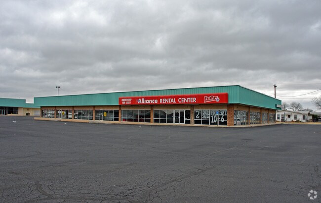
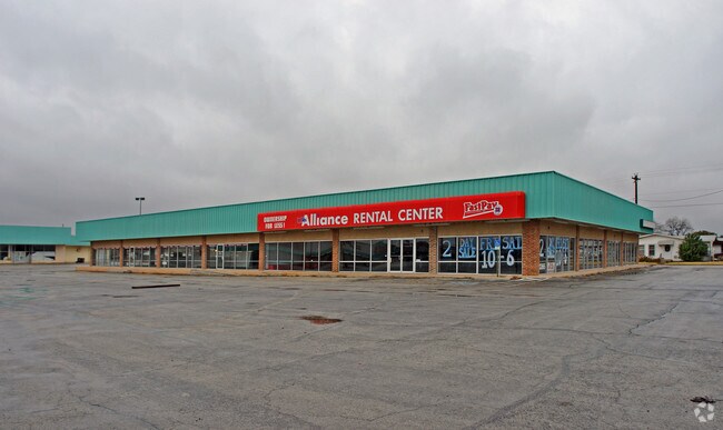
Property Record
1318 N Mockingbird Ln, Abilene, TX 79603

Property Detail
1318 N Mockingbird Ln
Abilene, TX
WESTWOOD ADDN REP, BLOCK 9, LOT 201 REP, ACRES 5.527
24437
TAYLOR
Multipleuses
Texas
AE The base floodplain where base flood elevations are provided. AE Zones are now used on new format FIRMs instead of A1-A30 Zones.
201
2024
5.53 AC
2025
Westwood Richland
010600
Other Market Areas
62,822 SF
NEARBY LISTINGS FOR SALE OR LEASE
DEMOGRAPHICS near 1318 N Mockingbird Ln
1 mile
3 mile
5 mile
2025 Total Population
14,098
60,045
99,197
2030 Population
14,431
62,167
102,744
Pop Growth 2025-2030
+ 2.36%
+ 3.53%
+ 3.58%
Average Age
37
37
37
2025 Total Households
5,134
22,376
38,479
HH Growth 2025-2030
+ 2.63%
+ 3.76%
+ 3.71%
Median Household Inc
$55,789
$51,908
$55,025
Avg Household Size
2.60
2.40
2.40
2025 Avg HH Vehicles
2.00
2.00
2.00
Median Home Value
$120,346
$125,620
$157,592
Median Year Built
1956
1956
1967
Nearby Places
Map Layers
Map Styles
 Street
 Aerial
Transit
 Traffic
 Biking
Places
Listings with unknown addresses are not visible on the map
- Restaurants
- Banks
- Shops
- Fitness
- Groceries
PUBLIC TRANSPORTATION
AIRPORT
Abilene Regional
Drive
Walk
Distance
Abilene Regional
16 min
8.0 mi
Freight Ports
Calhoun Port
Drive
Walk
Distance
Calhoun Port
440 min
377.9 mi
Nearby Properties
Address
Land Use
TOTAL SIZE
Lot Size
Zoning
Address
Land Use
TOTAL SIZE
Lot Size
Zoning
24.36 AC
Address
Land Use
TOTAL SIZE
Lot Size
Zoning
812,955 SF
99.27 AC
Address
Land Use
TOTAL SIZE
Lot Size
Zoning
169,821 SF
3.59 AC
Address
Land Use
TOTAL SIZE
Lot Size
Zoning
600,001 SF
39.40 AC
Address
Land Use
TOTAL SIZE
Lot Size
Zoning
183,321 SF
11.67 AC
Address
Land Use
TOTAL SIZE
Lot Size
Zoning
141,777 SF
36.78 AC
Address
Land Use
TOTAL SIZE
Lot Size
Zoning
95,893 SF
15.89 AC
Address
Land Use
TOTAL SIZE
Lot Size
Zoning
144,349 SF
11.07 AC
Address
Land Use
TOTAL SIZE
Lot Size
Zoning
342,750 SF
34.54 AC
Address
Land Use
TOTAL SIZE
Lot Size
Zoning
176,378 SF
36.99 AC
Address
Land Use
TOTAL SIZE
Lot Size
Zoning
73,947 SF
9.89 AC
Address
Land Use
TOTAL SIZE
Lot Size
Zoning
71,515 SF
9.94 AC
Address
Land Use
TOTAL SIZE
Lot Size
Zoning
75,482 SF
137.60 AC
Address
Land Use
TOTAL SIZE
Lot Size
Zoning
2.63 AC
Address
Land Use
TOTAL SIZE
Lot Size
Zoning
84,335 SF
4.68 AC
Address
Land Use
TOTAL SIZE
Lot Size
Zoning
52,028 SF
3.62 AC
Address
Land Use
TOTAL SIZE
Lot Size
Zoning
62,823 SF
9.39 AC
Address
Land Use
TOTAL SIZE
Lot Size
Zoning
2.63 AC
Address
Land Use
TOTAL SIZE
Lot Size
Zoning
77,187 SF
3.58 AC
Address
Land Use
TOTAL SIZE
Lot Size
Zoning
42,509 SF
8.63 AC
Address
Land Use
TOTAL SIZE
Lot Size
Zoning
38,150 SF
3.52 AC
Address
Land Use
TOTAL SIZE
Lot Size
Zoning
54,844 SF
12.70 AC
Address
Land Use
TOTAL SIZE
Lot Size
Zoning
473,106 SF
4.68 AC
Address
Land Use
TOTAL SIZE
Lot Size
Zoning
115,042 SF
7.68 AC
Address
Land Use
TOTAL SIZE
Lot Size
Zoning
82,414 SF
18.05 AC
Address
Land Use
TOTAL SIZE
Lot Size
Zoning
115,808 SF
5.21 AC
Address
Land Use
TOTAL SIZE
Lot Size
Zoning
241,784 SF
24.28 AC
Address
Land Use
TOTAL SIZE
Lot Size
Zoning
50,128 SF
2.50 AC
Address
Land Use
TOTAL SIZE
Lot Size
Zoning
177,960 SF
8.56 AC
Address
Land Use
TOTAL SIZE
Lot Size
Zoning
163,160 SF
1.91 AC
The World's #1 Commercial Real Estate Marketplace
Connect with us
© 2026 CoStar Group
The information above has been obtained from sources believed reliable. While we do not doubt its accuracy we have not verified it and make no guarantee, warranty or representation about it. It is your responsibility to independently confirm its accuracy and completeness. Any projections, opinions, assumptions, or estimates used are for example only and do not represent the current or future performance of the property. The value of this transaction to you depends on tax and other factors which should be evaluated by your tax, financial, and legal advisors. You and your advisors should conduct a careful, independent investigation of the property to determine to your satisfaction the suitability of the property for your needs.