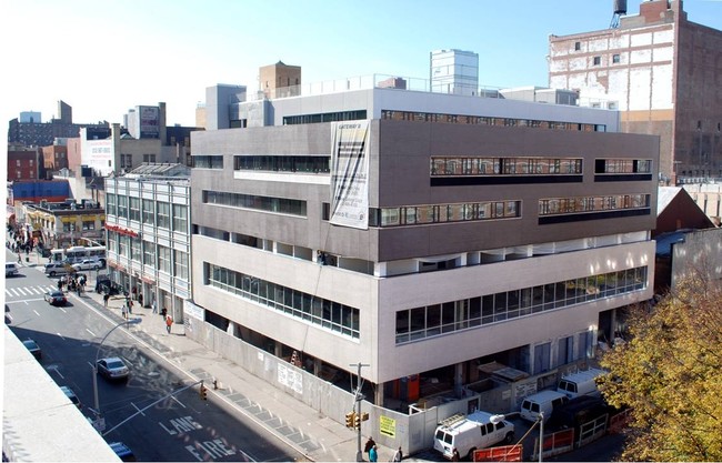
Property Record
132 E 126Th St, New York, NY 10035


Current Lease Availabilities
NEARBY LISTINGS FOR SALE OR LEASE
Property Detail
132 E 126Th St
1774-0056
Manhattan
Officebuilding
New York
X
56
3604970091F
0.21 AC
2024
Harlem/North Manhattan
2025
New York City
019600
New York-Jersey City-White Plains, NY-NJ
58,948 SF
DEMOGRAPHICS near 132 E 126Th St
1 mile
3 mile
5 mile
2024 Total Population
179,667
1,218,016
2,726,184
2029 Population
165,590
1,130,491
2,548,636
Pop Growth 2024-2029
(7.84%)
(7.19%)
(6.51%)
Average Age
40
40
40
2024 Total Households
75,852
510,824
1,126,135
HH Growth 2024-2029
(8.02%)
(7.60%)
(6.84%)
Median Household Inc
$41,152
$60,010
$64,783
Avg Household Size
2.20
2.20
2.30
2024 Avg HH Vehicles
.00
.00
.00
Median Home Value
$783,088
$887,475
$763,348
Median Year Built
1960
1953
1955
Nearby Places
Map Layers
Map Styles
 Street
 Aerial
Transit
 Traffic
 Biking
Places
Listings with unknown addresses are not visible on the map
- Restaurants
- Banks
- Shops
- Fitness
- Groceries
PUBLIC TRANSPORTATION
TRANSIT/SUBWAY
125 Street (4,5,6 Line) (4 - New York MTA Subway (The Subway), 5 - New York MTA Subway (The Subway), 6 - New York MTA Subway (The Subway))
Drive
Walk
Distance
125 Street (4,5,6 Line) (4 - New York MTA Subway (The Subway), 5 - New York MTA Subway (The Subway), 6 - New York MTA Subway (The Subway))
2 min
2 min
0.1 mi
Harlem-125th Street Station (Harlem Line - Metro-North Commuter Railroad Company (Metro-North), Hudson Line - Metro-North Commuter Railroad Company (Metro-North), New Haven Line - Metro-North Commuter Railroad Company (Metro-North))
Drive
Walk
Distance
Harlem-125th Street Station (Harlem Line - Metro-North Commuter Railroad Company (Metro-North), Hudson Line - Metro-North Commuter Railroad Company (Metro-North), New Haven Line - Metro-North Commuter Railroad Company (Metro-North))
1 min
2 min
0.1 mi
125 Street (2,3 Line) (2 - New York MTA Subway (The Subway), 3 - New York MTA Subway (The Subway))
Drive
Walk
Distance
125 Street (2,3 Line) (2 - New York MTA Subway (The Subway), 3 - New York MTA Subway (The Subway))
1 min
10 min
0.5 mi
116 Street (4,6 Line) (4 - New York MTA Subway (The Subway), 6 - New York MTA Subway (The Subway))
Drive
Walk
Distance
116 Street (4,6 Line) (4 - New York MTA Subway (The Subway), 6 - New York MTA Subway (The Subway))
3 min
11 min
0.5 mi
138 Street (4 - New York MTA Subway (The Subway), 5 - New York MTA Subway (The Subway))
Drive
Walk
Distance
138 Street (4 - New York MTA Subway (The Subway), 5 - New York MTA Subway (The Subway))
4 min
20 min
1.0 mi
COMMUTER RAIL
Harlem-125th Street Station (Harlem Line - Metro-North Commuter Railroad Company (Metro-North), Hudson Line - Metro-North Commuter Railroad Company (Metro-North), New Haven Line - Metro-North Commuter Railroad Company (Metro-North))
Drive
Walk
Distance
Harlem-125th Street Station (Harlem Line - Metro-North Commuter Railroad Company (Metro-North), Hudson Line - Metro-North Commuter Railroad Company (Metro-North), New Haven Line - Metro-North Commuter Railroad Company (Metro-North))
1 min
2 min
0.1 mi
Yankees-E 153rd Street Station (Hudson Line - Metro-North Commuter Railroad Company (Metro-North))
Drive
Walk
Distance
Yankees-E 153rd Street Station (Hudson Line - Metro-North Commuter Railroad Company (Metro-North))
5 min
1.8 mi
AIRPORT
LaGuardia
Drive
Walk
Distance
LaGuardia
14 min
6.2 mi
John F Kennedy International
Drive
Walk
Distance
John F Kennedy International
27 min
17.4 mi
Newark Liberty International
Drive
Walk
Distance
Newark Liberty International
31 min
24.2 mi
Freight Ports
NY - Red Hook Container Terminal
Drive
Walk
Distance
NY - Red Hook Container Terminal
27 min
12.3 mi
Nearby Properties
Address
Land Use
TOTAL SIZE
Lot Size
Zoning
Address
Land Use
TOTAL SIZE
Lot Size
Zoning
97.14 AC
R7-2
Address
Land Use
TOTAL SIZE
Lot Size
Zoning
1.22 AC
R7-2
Address
Land Use
TOTAL SIZE
Lot Size
Zoning
0.92 AC
R7-2
Address
Land Use
TOTAL SIZE
Lot Size
Zoning
97.14 AC
R7-2
Address
Land Use
TOTAL SIZE
Lot Size
Zoning
4,380,201 SF
97.06 AC
R7-2
Address
Land Use
TOTAL SIZE
Lot Size
Zoning
5,519,372 SF
409.21 AC
C8-2
Address
Land Use
TOTAL SIZE
Lot Size
Zoning
1,233,684 SF
16.94 AC
PARK
Address
Land Use
TOTAL SIZE
Lot Size
Zoning
3,693,539 SF
8.37 AC
R8
Address
Land Use
TOTAL SIZE
Lot Size
Zoning
400,160 SF
10.96 AC
R7-2
Address
Land Use
TOTAL SIZE
Lot Size
Zoning
2,215,000 SF
6.43 AC
R9
Address
Land Use
TOTAL SIZE
Lot Size
Zoning
2,230,742 SF
6.33 AC
R9
Address
Land Use
TOTAL SIZE
Lot Size
Zoning
1,368,870 SF
16.86 AC
R8
Address
Land Use
TOTAL SIZE
Lot Size
Zoning
2,278,432 SF
5.99 AC
R7-2
Address
Land Use
TOTAL SIZE
Lot Size
Zoning
667,517 SF
1.11 AC
R8B
Address
Land Use
TOTAL SIZE
Lot Size
Zoning
667,517 SF
1.11 AC
R8B
Address
Land Use
TOTAL SIZE
Lot Size
Zoning
667,517 SF
1.11 AC
R8B
Address
Land Use
TOTAL SIZE
Lot Size
Zoning
667,517 SF
1.11 AC
R8B
Address
Land Use
TOTAL SIZE
Lot Size
Zoning
667,517 SF
1.11 AC
R8B
Address
Land Use
TOTAL SIZE
Lot Size
Zoning
667,517 SF
1.11 AC
R8B
Address
Land Use
TOTAL SIZE
Lot Size
Zoning
667,517 SF
1.11 AC
R8B
Address
Land Use
TOTAL SIZE
Lot Size
Zoning
667,517 SF
1.11 AC
R8B
Address
Land Use
TOTAL SIZE
Lot Size
Zoning
667,517 SF
1.11 AC
R8B
Address
Land Use
TOTAL SIZE
Lot Size
Zoning
667,517 SF
1.11 AC
R8B
Address
Land Use
TOTAL SIZE
Lot Size
Zoning
667,517 SF
1.11 AC
R8B
Address
Land Use
TOTAL SIZE
Lot Size
Zoning
667,517 SF
1.11 AC
R8B
Address
Land Use
TOTAL SIZE
Lot Size
Zoning
667,517 SF
1.11 AC
R8B
Address
Land Use
TOTAL SIZE
Lot Size
Zoning
667,517 SF
1.11 AC
R8B
Address
Land Use
TOTAL SIZE
Lot Size
Zoning
667,517 SF
1.11 AC
R8B
Address
Land Use
TOTAL SIZE
Lot Size
Zoning
667,517 SF
1.11 AC
R8B
Address
Land Use
TOTAL SIZE
Lot Size
Zoning
667,517 SF
1.11 AC
R8B
The World's #1 Commercial Real Estate Marketplace
Connect with us
© 2026 CoStar Group
The information above has been obtained from sources believed reliable. While we do not doubt its accuracy we have not verified it and make no guarantee, warranty or representation about it. It is your responsibility to independently confirm its accuracy and completeness. Any projections, opinions, assumptions, or estimates used are for example only and do not represent the current or future performance of the property. The value of this transaction to you depends on tax and other factors which should be evaluated by your tax, financial, and legal advisors. You and your advisors should conduct a careful, independent investigation of the property to determine to your satisfaction the suitability of the property for your needs.