Property Record
1327 Hardin Rd, Beasley, TX 77417

Property Detail
1327 Hardin Rd
0397-00-002-0020-901
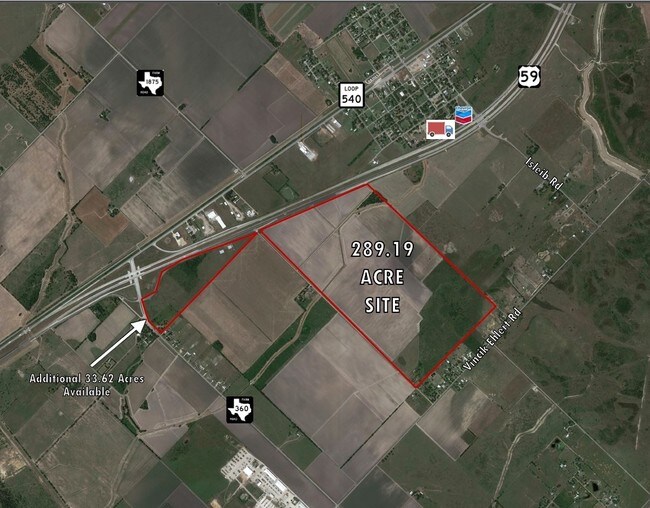
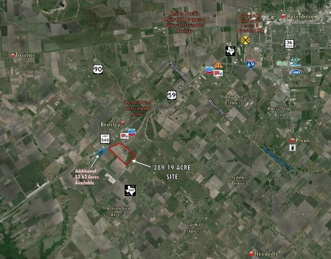
0397 S N CROSS, TRACT 2, ACRES 289.19
Farms
FORT BEND
QOY
Texas
B and X Area of moderate flood hazard, usually the area between the limits of the 100-year and 500-year floods.
2
2024
289.19 AC
2025
Southwest Outlier
675800
Houston
900 SF
Houston-Pasadena-The Woodlands, TX
NEARBY LISTINGS FOR SALE OR LEASE
DEMOGRAPHICS near 1327 Hardin Rd
1 mile
3 mile
5 mile
2025 Total Population
975
3,636
7,154
2030 Population
1,126
4,198
8,247
Pop Growth 2025-2030
+ 15.49%
+ 15.46%
+ 15.28%
Average Age
37
39
39
2025 Total Households
309
1,204
2,359
HH Growth 2025-2030
+ 15.86%
+ 15.86%
+ 15.68%
Median Household Inc
$71,511
$61,055
$65,288
Avg Household Size
3.20
3.00
3.00
2025 Avg HH Vehicles
2.00
2.00
2.00
Median Home Value
$403,226
$443,382
$435,547
Median Year Built
1987
1989
1991
Nearby Places
Map Layers
Map Styles
 Street
 Aerial
Layers
 Traffic
 Biking
Places
Listings with unknown addresses are not visible on the map
- Restaurants
- Banks
- Shops
- Fitness
- Groceries
SALE & LEASE HISTORY
LISTING DATE
SALE/LEASE

Mar 01, 2017
For Sale
Nearby Properties
Address
Land Use
TOTAL SIZE
Lot Size
Zoning
Address
Land Use
TOTAL SIZE
Lot Size
Zoning
100,000 SF
1.32 AC
Address
Land Use
TOTAL SIZE
Lot Size
Zoning
208.52 AC
OST
Address
Land Use
TOTAL SIZE
Lot Size
Zoning
194.64 AC
Address
Land Use
TOTAL SIZE
Lot Size
Zoning
828,228 SF
38.96 AC
Address
Land Use
TOTAL SIZE
Lot Size
Zoning
129.15 AC
Address
Land Use
TOTAL SIZE
Lot Size
Zoning
75.19 AC
Address
Land Use
TOTAL SIZE
Lot Size
Zoning
110,714 SF
14.34 AC
Address
Land Use
TOTAL SIZE
Lot Size
Zoning
159.79 AC
OTYM
Address
Land Use
TOTAL SIZE
Lot Size
Zoning
21.35 AC
S
Address
Land Use
TOTAL SIZE
Lot Size
Zoning
Address
Land Use
TOTAL SIZE
Lot Size
Zoning
140.86 AC
Address
Land Use
TOTAL SIZE
Lot Size
Zoning
77.67 AC
OS
Address
Land Use
TOTAL SIZE
Lot Size
Zoning
13,200 SF
2.20 AC
S
Address
Land Use
TOTAL SIZE
Lot Size
Zoning
13,920 SF
3 AC
SM
Address
Land Use
TOTAL SIZE
Lot Size
Zoning
56.70 AC
Z
Address
Land Use
TOTAL SIZE
Lot Size
Zoning
47,860 SF
4 AC
YS
Address
Land Use
TOTAL SIZE
Lot Size
Zoning
72.55 AC
Address
Land Use
TOTAL SIZE
Lot Size
Zoning
44,400 SF
70.82 AC
O
Address
Land Use
TOTAL SIZE
Lot Size
Zoning
41,500 SF
5 AC
Address
Land Use
TOTAL SIZE
Lot Size
Zoning
45 AC
QY
Address
Land Use
TOTAL SIZE
Lot Size
Zoning
140 AC
TY
Address
Land Use
TOTAL SIZE
Lot Size
Zoning
6,891 SF
4.01 AC
XY
Address
Land Use
TOTAL SIZE
Lot Size
Zoning
11,820 SF
2.57 AC
MY
Address
Land Use
TOTAL SIZE
Lot Size
Zoning
22.16 AC
Address
Land Use
TOTAL SIZE
Lot Size
Zoning
25 AC
R
Address
Land Use
TOTAL SIZE
Lot Size
Zoning
58.43 AC
SYO
Address
Land Use
TOTAL SIZE
Lot Size
Zoning
784 SF
1.67 AC
X
Address
Land Use
TOTAL SIZE
Lot Size
Zoning
1,097 SF
18.77 AC
YQ
Address
Land Use
TOTAL SIZE
Lot Size
Zoning
83.29 AC
YS
Address
Land Use
TOTAL SIZE
Lot Size
Zoning
99.90 AC
The World's #1 Commercial Real Estate Marketplace
Connect with us
© 2026 CoStar Group
The information above has been obtained from sources believed reliable. While we do not doubt its accuracy we have not verified it and make no guarantee, warranty or representation about it. It is your responsibility to independently confirm its accuracy and completeness. Any projections, opinions, assumptions, or estimates used are for example only and do not represent the current or future performance of the property. The value of this transaction to you depends on tax and other factors which should be evaluated by your tax, financial, and legal advisors. You and your advisors should conduct a careful, independent investigation of the property to determine to your satisfaction the suitability of the property for your needs.